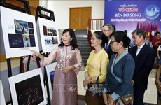
Evidence of national sea sovereignty shown in Quang Nam
Maps and documents which are historical and legal evidence proving
Vietnam’s sovereignty over archipelagos in the East Sea are being
showcased in Thang Binh district of central Quang Nam province.
Maps and documents which are historical and legal evidence proving
Vietnam’s sovereignty over archipelagos in the East Sea are being
showcased in Thang Binh district of central Quang Nam province.
The exhibits include replicas of old Vietnamese documents on the country’s establishment and enforcement of its sovereignty over Hoang Sa (Paracel) and Truong Sa (Spratly) archipelagos, along with royal documents from Vietnam’s Nguyen Dynasty and western maps showing the country’s possession of the two archipelagos.
Also on show are maps of China without the islands issued by western countries and China itself, documents on the archipelagos before and after 1975, and related researches by Vietnamese and foreign experts.
One notable item is a map of Quang Nam drawn in 1810 showing Hoang Sa islands, named Cat Vang in Vietnam ’s ancient Nom script, off the coast of the province.
The display also features decisions by Kings Minh Mang, Thieu Tri, and Tu Duc of the Nguyen Dynasty to assign Vo Van Tay, a Quang Nam native, as the head of a naval soldier team patrolling Hoang Sa.
Director of the Quang Nam Department of Information and Communications Pham Hong Quang said the items, collected in Vietnam and other countries help testify to Vietnam ’s sovereignty over Hoang Sa and Truong Sa and raise public awareness of the national sovereignty protection.
The exhibition, opened on May 19, at the Centre for Culture and Sports of Thang Binh district will last until May 22.-VNA


You should also see

PM urges stronger cooperation between Vietnamese, Chinese Ministries of Justice
Prime Minister Pham Minh Chinh has requested the Ministries of Justice of Vietnam and China to foster cooperation and mutual support, making them to be on a par with the height of the bilateral relations.


See more
 Culture - Sports
Vietnamese film wins highest award at Asian festival in Italy
“Ben trong vo ken vang” (Inside the Yellow Cocoon Shell) by Vietnamese director Pham Thien An has won the best feature film award at the 21st Asian Film Festival held in Rome.
 Culture - Sports
Can Tho treats visitors to giant sizzling crepe at folk cake festival
Visitors at the 11th Southern Traditional Cake Festival in Can Tho city were pleasantly surprised to witness 15 chefs come together to make a giant sizzling rice crepe with a diameter of up to 3 metres. The crepe was hailed as the largest ever seen in the Mekong Delta.
 Culture - Sports
Vietnamese canoeist wins gold medal at Asian championships
Vietnamese canoeist Diep Thi Huong won a gold medal in the women’s 500m category at the Asian Canoe Sprint Championships 2024, the Vietnam Canoeing, Rowing and Sailing Federation said on April 19.
 Culture - Sports
Google Arts & Culture exhibition spotlights Trang An Landscape Complex
An online exhibition featuring the Trang An Landscape Complex in Vietnam’s northern Ninh Binh province was launched on Google Arts & Culture on April 18 by the complex's management board with the support of Google Arts & Culture and UNESCO World Heritage Centre.
 Culture - Sports
Exhibition on Vietnam seas and islands opens in Laos
A photo exhibition on Vietnam’s seas and islands themed “Fatherland by the waves” opened in the Lao capital city ofVientiane on April 18.