Exhibition helps inland people get close to the sea
People in the northwestern mountainous province of Dien Bien have
been given a chance to learn more about the national sovereignty off the
coast of their homeland through an exhibition at the Dien Bien Phu
Victory Museum.
People in the northwestern mountainous province of Dien Bien have
been given a chance to learn more about the national sovereignty off the
coast of their homeland through an exhibition at the Dien Bien Phu
Victory Museum.
The event, starting from June 4, features 50 maps, six of which were drawn by Vietnam in the 15 th century and 25 of which hailed from western and other Southeast Asian countries in the same era.
Nineteen maps drawn and issued by China in the 20 th century have also been put on display.
All the maps depict Hoang Sa (Paracel) and Truong Sa (Spratly) archipelagos as under Vietnam’s sovereignty.
The month-long event also showcases nearly 100 photos capturing activities of Dien Bien agencies and people in support of the country’s sea and island areas.
Director of the museum Vu Nam Hai said besides imparting sovereignty knowledge to visitors, the exhibition also aims to infuse the young generation with patriotism and determination to safeguard the country’s territory.-VNA


You should also see

Investor confidence gains traction on improved business climate
Better investment climate, with simplified administrative producers and special incentives, has helped improve investor confidence, thus catalysing investments from a wider pool of both domestic and international investors for socio-economic development.


See more
 Culture - Sports
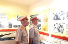
Hanoi exhibition highlights Dien Bien Phu Victory
The Vietnam Military History Museum in Hanoi is hosting a photo exhibition on the Dien Bien Phu battle to mark the 70th anniversary of the Dien Bien Phu Victory (May 7, 1954-2024).
 Culture - Sports
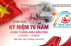
Film week to mark 70th anniversary of Dien Bien Phu Victory
A film week is taking place in Dien Bien Phu city, the northwestern province of Dien Bien, from April 24 to 30 in celebration of the 70th anniversary of the Dien Bien Phu Victory (May 7, 1954 - 2024).
 Culture - Sports
Three Vietnamese female referees to officiate at U17 Women's Asian Cup finals
Three Vietnamese female referees have been invited to officiate at the 2024 AFC U17 Women’s Asian Cup finals, the Vietnam Football Federation (VFF) has announced.
 Culture - Sports
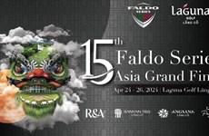
Golf: Faldo Series Asia 2024 commences in Thua Thien-Hue
The 15th Faldo Series Asia Grand Final kicked off in the central province of Thua Thien-Hue on April 24, the Vietnam Golf Association announced.
 Culture - Sports
Art programme highlights significance of Dien Bien Phu Victory
The Army Radio - Television Centre under the General Department of Politics of the Vietnam People's Army (VPA) on April 23 evening held a special art programme highlighting the importance and significance of the Dien Bien Phu Victory on the occasion of the victory's 70th anniversary (May 7, 1954-2024).