New storms head towards East Sea
A tropical depression that is forecast to strengthen into a typhoon is heading to the southeast of the East Sea.
A tropical depression that is forecast to strengthen into a typhoon is heading to the southeast of the East Sea.
By 7am on November 5, the low pressure centre was above the north end of Palawan Island of the Philippines, with winds moving between 50 and 61 km per hour.
The National Centre for Hydro-meteorological Forecasting said that by 7am on November 6 it will be over the north of Truong Sa (Spratly) Archipelago, about 430km east and southeast of the central provinces from Phu Yen to Binh Thuan.
The centre also said that by 7am on November 5, a powerful storm born in the Pacific Ocean was at latitude 6.5 degrees north and longitude 145.9 degrees east. Storm Haiyan is moving in a west and north-west direction with winds of 25km per hour, and is predicted to enter the east part of the East Sea .
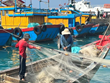
In response to the two storms, the Central Steering Committee for Flood and Storm Control asked central provinces and cities of Da Nang to Ca Mau and Kien Giang to call and guide ships away from dangerous areas, including the West Sea (Ca Mau and Kien Giang waters).
They were asked to take measures to evacuate local people living in coastal areas, protect fish farming equipment and examine works.
The provinces, cities and ministries are ready to control transport in easily flooded routes, wharfs and tunnels, while keeping an eye on rain to give warnings to those living in areas vulnerable to flooding and landslides.-VNA
By 7am on November 5, the low pressure centre was above the north end of Palawan Island of the Philippines, with winds moving between 50 and 61 km per hour.
The National Centre for Hydro-meteorological Forecasting said that by 7am on November 6 it will be over the north of Truong Sa (Spratly) Archipelago, about 430km east and southeast of the central provinces from Phu Yen to Binh Thuan.
The centre also said that by 7am on November 5, a powerful storm born in the Pacific Ocean was at latitude 6.5 degrees north and longitude 145.9 degrees east. Storm Haiyan is moving in a west and north-west direction with winds of 25km per hour, and is predicted to enter the east part of the East Sea .
In response to the two storms, the Central Steering Committee for Flood and Storm Control asked central provinces and cities of Da Nang to Ca Mau and Kien Giang to call and guide ships away from dangerous areas, including the West Sea (Ca Mau and Kien Giang waters).
They were asked to take measures to evacuate local people living in coastal areas, protect fish farming equipment and examine works.
The provinces, cities and ministries are ready to control transport in easily flooded routes, wharfs and tunnels, while keeping an eye on rain to give warnings to those living in areas vulnerable to flooding and landslides.-VNA


You should also see

PM expresses gratitude to contributors to Dien Bien Phu Victory
Prime Minister Pham Minh Chinh paid homage to General Vo Nguyen Giap and met with families of soldiers fighting in the Dien Bien Phu Campaign and policy beneficiaries in Muong Phang commune of Dien Bien Phu city, the northwestern province of Dien Bien, on April 16.


See more
 Environment
Solutions proposed to tackle growing challenge of electronic waste
Vietnam faces a growing problem with electronic waste (e-waste), according to a study by the Hanoi University of Science and Technology's Centre of Science-Technology and Environment.
 Environment
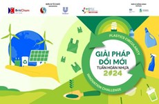
Contest seeks innovative solutions to recycle plastic
The innovative solution contest 2024 was launched in Hanoi on April 12, aiming to seek solutions in the plastic circular value chain, especially new and creative solutions in improving the capacity to collect, process and recycle plastic packaging.
 Environment
Co To calls for actions to prevent plastic pollution in tourism activities
Co To island district in the northeastern province of Quang Ninh has asked local accommodation facilities and travel firms to apply environmental protection measures in tourism business activities to build an island free of plastic bags and other single-use items.
 Environment
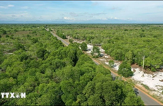
Eight coastal localities get more support in forestry modernisation
The 4,040 hectares of forests planted and restored in the first phase of the World Bank (WB)-funded Forest Sector Modernisation and Coastal Resilience Enhancement Project will receive further care, as Prime Minister Pham Minh Chinh has issued a decision on the adjustment of the project investment, an official has said.
 Environment
Binh Duong, UK cooperate in promoting green energy
The People’s Committee of the southern province of Binh Duong, in collaboration with the British Consulate General in Ho Chi Minh City, organised a conference on green energy on April 9, aiming to optimise the use of renewable energy and facilitate knowledge exchange between the locality and experts on sustainable energy development.