Nguyen Lords exercise sovereignty over Hoang Sa, Truong Sa
Vietnam has established and exercised its national sovereignty
over Hoang Sa and Truong Sa archipelagoes in a peaceful manner and in
line with international law.
Vietnam has sufficient legal basis and historical evidence to affirm
its sovereignty rights over Truong Sa and Hoang Sa archipelagoes. An
international conference on the East Sea will be held in Hanoi
from November 11-12. On this occasion, the Vietnam News Agency would
like to introduce the article “ How did the Nguyen Lords Excercise
Sovereignty over Hoang Sa and Truong Sa Archipelagoes ?” published on
the website of Vietnam’s Sovereign Boundaries, the National Boundary
Commission, Ministry of Foreign Affairs in May, 2013.
Vietnam has established and exercised its national sovereignty over Hoang Sa and Truong Sa archipelagoes in a peaceful manner and in line with international law.
Hoang Sa Flotilla – the first feudal state-controlled group exercising management in the East Sea – is a forceful evidence of Vietnam’s sovereignty over Hoang Sa and Truong Sa archipelagoes.
In addition, the missions of the Flotilla clearly reflected the fact that Vietnam had established and exercised its sovereignty over Hoang Sa and Truong Sa archipelagoes in a peaceful and continuous manner in accordance with international law.
Nguyen Lords and Kings demonstrated their will as a State by setting up a state-managed flotilla whose operation was conducted on an annual basis and put under the state disciplines. Accordingly, the first task of the Flotilla was to exploit resources at sea.
The book “Phu bien tap luc” (Miscellany on the Pacification at the Frontier) written by scholar Le Quy Don in 1776 reads, “Initially the Nguyen set up the Hoang Sa Flotilla with 70 members, who were recruited from An Vinh commune; they took turn to go on duty every March, taking along enough food for six months, sailing in five small fishing boats for three days and three nights to reach the islands. Once arriving on the islands, they were free to collect things and caught as many birds and fish for food as they like. They collected large quantities of goods from ship wrecks included sabres, silver earrings, silver coins, silver rings, copper ware, tin ingots, lead, guns, ivory, bee wax, porcelain ware, as well as sea turtle shells, sea cucumbers and shells. The team returned in August of the same year, going through the Eo estuary to go to Phu Xuan Citadel to hand over the things they had gathered. Having the things weighed and classified, they sold their conches, turtles and sea-cucumbers, got certificates and went home.”
However, according to Prof. Dr. Nguyen Quang Ngoc, former director of the Institute of Vietnamese Studies and Development Sciences under the Vietnam National University - Hanoi , the main task of the Hoang Sa Flotilla was to control and protect the waters and islands of the nation. He said: The main function of the Hoang Sa team is to check, control and protect the waters and islands claimed by the Nguyen Lords. When the country’s sovereignty over sea and islands was extended, the Hoang Sa Flotilla itself could not manage all, so the Nguyen Lords decided to set up a new team, the Bac Hai ( North Sea ) Flotilla, a division of the Hoang Sa Flotilla. The Bac Hai Flotilla team also carried the task of protecting, managing the country’s territorial waters in the South such as Truong Sa (Spratly) Islands, Con Lon Island and Phu Quoc island...”.
The book Dai Nam thuc luc chinh bien (Veritable Records of Dai Nam) (1848) records a range of state-level activities via recounts of Hoang Sa Flotilla’s operation.
In the two consecutive years of 1815 and 1816, King Gia Long sent the Hoang Sa Flotilla to Hoang Sa to examine and measure sea routes. The duty was clearly defined. Dai Nam Thuc Luc Chinh Bien (Veritable Records of Dai Nam) as well as Kham Dinh Dai Nam Hoi Dien Su Le (Compendium of Institutions and Administrative Cases of Dai Nam Established by Imperial Order) write: “At every island, every estuary, when the boats came, they measured the length and the width, the breadth and the height, the circumference of the island, the depth of the sea along the shore, finding out whether there was any submerged sandbank or rock, and the conditions were dangerous or normal. After exploring and measuring, they had to draw a map. They had to think about their departure date, which estuary they started, which direction they followed to arrive at the island, then based on the route to estimate the distance they had travelled in miles. From the island, they looked towards the shore to determine which locality on shore was corresponding to that island and estimate the distance from there to the shore. This must be written down in details in the map to submit to the superiority”.
Thorough preparation was made for each voyage on duty to Hoang Sa archipelago. The work was directed by the highest authorities, the King and Bo Cong (the Ministry of Industry), executed by the naval force in combination with citadel guards and the provinces of Quang Ngai and Binh Dinh. King Minh Mang himself for many times issued royal decrees on reward and penalty. Normally, members of Hoang Sa Flotilla were rewarded with one or two quan tien and enjoyed tax exemption for their hard and dangerous work.
In the 14th year under King Minh Mang’s reign (1833), King Minh Mang ordered Bo Cong to dispatch people to Hoang Sa archipelago to erect sovereignty stele and from the 17th Minh Mang year (1836), a team was sent to Hoang Sa archipelago every year to erect markers and steles apart from measuring sea routes and drawing maps.
“Dai Nam thuc luc chinh bien, de nhi ky” (Veritable Records of Dai Nam, second reign) reads that: “King Minh Mang approved Bo Cong’s proposal to assign the Naval Force commander Pham Huu Nhat to lead warships on a mission to Hoang Sa, taking along ten wooden steles to use as markers. Each wooden stele was 5 thuoc (equivalent to 2 metres) long, 6 tac (equivalent to 0.24 metres) wide, and 1 tac (equivalent to 0.04 metre) thick; and engraved with the words: The 17th year of the Minh Mang’s reign, the Binh Than year (1836), Naval Commander Pham Huu Nhat, under the King’s order to go to Hoang Sa for surveys and measurement, has arrived here and erected this marker .”
According to Prof. Dr. Nguyen Quang Ngoc, former director of the Institute of Vietnamese Studies and Development Sciences, Vietnam National University , Hanoi , this action marked a very important milestone in the affirmation of Vietnam 's sovereignty. The former director of the Institute of Vietnamese Studies and Development Sciences said: “The building of a sovereignty flag in the land is considered the pinnacle of the enforcement of sovereignty over that piece of land. Apart from claiming and exerting sovereignty through such activities, kings also sent people to measure sea routes, research, survey, and event setting up plans on inspection and monitor the exercise of the country’s sovereignty”.
Vietnam’s Lords and Kings also paid great attention to the construction of pagodas, temples, and planting trees at Hoang Sa archipelago. In the 16 th Minh Mang Year (1835), King Minh Mang assigned naval officer Pham Van Nguyen and a mission comprising soldiers, citadel guards, and conscripted labourers from the two provinces of Quang Ngai and Binh Dinh, to transport materials to the islands to build temples and plant trees there, explaining that trees would serve as sign-posts for boats to identify locations on passage to avoid accidents.
All those activities were recorded in Chau ban (official documents) under the Nguyen dynasty as well as other documents by local authorities currently preserved at relevant archives.
Hence, since the beginning of the 17th century - the time of the Nguyen Lords - to the first half of the 19 th century of the Nguyen dynasty, the Hoang Sa Flotilla performed the task of state management over Hoang Sa archipelago. This evidence affirmed that Vietnam had acquired sovereignty over Hoang Sa archipelago in line with regulations of international law at that time.
It is noteworthy that the affirmation of sovereignty did not meet with any objection from any other nation. Dr. Nguyen Nha, a researcher on Hoang Sa – Truong Sa history from the Vietnam Historians Association, said, “there was no obstacle to such activities of the Hoang Sa Flotilla. The Phu bien tap luc and our country’s official history recorded an incident when a boat of Hoang Sa Flotilla with two people on board drifted to Hainan Island ( China ), and the government of Hainan helped send them back to the home country, while they knew that the two men had been on a mission to Hoang Sa archipelago”.
These activities can be seen as territory management in a peaceful and continuous manner. Prof. Carlyle Thayer, Australian Defence Force Academy , said: “ China says they have irrefutable evidence that Hoang Sa belongs to the country. However, documents on Hoang Sa Flotilla prove that China ’s sovereignty claim over Hoang Sa remains a matter of controversy. Meanwhile, Vietnam ’s claim is on a solid basis. Hoang Sa team had economic and defence functions. At that time, the method to maintain sovereignty management was through regular visits to keep a close watch on resources and protect islands. And Hoang Sa team of Vietnam had performed such functions”.
It is clear that the feudal state of Vietnam was the first state in history to establish its sovereignty over Hoang Sa and Truong Sa archipelagoes. The sovereignty exercise is conducted in a real, continuous, peaceful manner which is in line with principles of law and international practices. We have sufficient legal evidence and valid historical documents to prove this evident truth. Therefore, any territorial dispute against Vietnam is contrary to international law.-VNA


You should also see
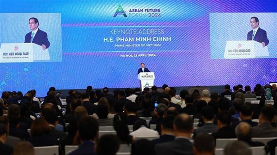
PM calls on ASEAN to pen strategic development vision
The Association of Southeast Asian Nations (ASEAN) should have a strategic and comprehensive vision, and improve its resilience capacity to grasp opportunities and handle global headwinds for stable and sustainable development, Prime Minister Pham Minh Chinh said on April 23.

See more
 Politics
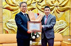
Japanese Ambassador receives friendship insignia
The Vietnam Union of Friendship Organisations (VUFO) on April 23 held a ceremony to present the “For peace and friendship among nations” insignia to Japanese Ambassador to Vietnam Yamada Takio.
 Politics
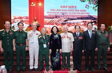
Dien Bien soldiers, youth volunteers meet in Hanoi
Nearly 300 soldiers and youth volunteers directly engaging in the Dien Bien Phu campaign 70 years ago looked back on the 56-day battle, the victory of which led to the signing of the Geneva Accords on ending the war and restoring peace in Indochina, at a meeting in Hanoi on April 23.
 Politics
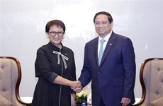
Prime Minister hosts Indonesian Foreign Minister
Prime Minister Pham Minh Chinh hosted a reception in Hanoi on April 23 for Indonesian Foreign Minister Retno Marsudi, who is now on an official visit to Vietnam and to co-chair the fifth meeting of the Vietnam-Indonesia Joint Committee on Bilateral Cooperation.
 Politics
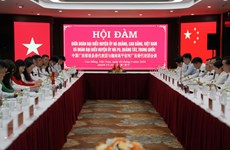
Vietnamese, Chinese localities enhance cooperation
Delegations of Ha Quang district’s Party Committee in the northern mountainous province of Cao Bang and Napo county’s Party Committee in China’s Guangxi province held talks on April 22 in Cao Bang city.
 Politics
☀️ Morning digest April 23
The following is a list of selected news summaries reported last night by the Vietnam News Agency.