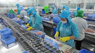
Technology supports fishermen’s operation at sea
A project on monitoring fishing boats, fishing grounds and aquaculture
resources using satellite technology, known in short as Movimar, is
being implemented in 28 coastal provinces and cities to facilitate
fishermen’s safe and productive operation at sea.
A project on monitoring fishing boats, fishing grounds and aquaculture
resources using satellite technology, known in short as Movimar, is
being implemented in 28 coastal provinces and cities to facilitate
fishermen’s safe and productive operation at sea.
Back in 2009, the French Government signed an agreement with Vietnam to provide 13.9 million EUR to the Movimar project, which is implemented from 2010 to 2014.
Under the project, fishing vessels will be equipped with satellite positioning machines.
The satellite positioning system includes two main parts: machines installed on the boats and the inshore monitoring system.
The sets of equipment on boats will automatically transfer co-ordinates and time from the boats to the monitoring center constantly every two hours. The received data will help the center keep track of the speed and direction of boats, thus providing timely support in case of emergency and assisting boats’ fishing activities.
Deputy Minister of Agriculture and Rural Development Vu Van Tam said that the Movimar project uses modern devices which can monitor fishing boats, take photos of weather and the sea using remote sensing technology.
On this basis, the system will deliver forecast on the weather and fishing fields, helping fishermen save costs, especially fuel, resulting in more effective catching and reduced risks.
The Deputy Minister noted that to meet the requirements of a new and technology-intensive project with many difficulties lying ahead, it is necessary to have well-trained staffs who are able to run the project.
On the other hand, there remain difficulties in installing devices and providing technical guidance to fishermen, requiring close coordination with contractors to provide training to fishermen and other users so that they can master the technical skills.
Regarding whether the project can cover all the domestic fishing fleets, Deputy Minister Vu Van Tam said that in the immediate future, 3,000 boats fishing offshore in 28 coastal provinces and cities will be selected to be equipped with the satellite devices.
Priority will be given to boats of more than 90 CV which will serve as head of a group of 5 to 10 smaller trawlers which have not get the device. Thus, the 3,000 satellite-connected boats will provide needed information to thousands of others while operating offshore.
Previously, forecasts on fishing ground were based on fishery data only. As a result, their accuracy was not high due to a lack of ocean research and remote sensing images.
Therefore, the project, which is equipped with technology of oceanographic remote sensing image processing, is expected to provide better forecast on fishing ground.
In 2013, a center of fishing ground forecast is scheduled to be established. The center will be managed by the Seafood Research Institute.
Representatives of the Management Board of agriculture projects (the investor of Movimar) said the project aims to perfect the sea fishing management information system, meeting requirements of industrialisation and modernisation of the aquatic sector, effectively and safely monitoring fish catch, contributing to ensuring the order, and national security and sovereignty at sea.
The French company, Collecte Localisation Satellites SA, is the project’s partner.
Its General Director Christophe Vassal said that the construction and operation of a database of oceanography-based fishing will serve the forecast on potential fishing grounds, improve quality of hydro- meteorological forecast, particularly on storms, tropical lows and other abnormal weather conditions at sea.
The Ministry of Agriculture and Rural Development is planning a budget to provide assistance to fishermen for paying subscription fee for satellite devices after 2014 when the project finishes.
As in other services such as mobile phones, those who want to continue using Movimar will have to pay fees. The Institute of Aquatic Research will also have to pay fee so that its center of fishing ground forecast will have access to updated information from satellites using the remote sensing technology and oceanography.-VNA


You should also see

Youths' efforts yield socio-economic fruits
Many activities were carried out across the nation during the Vietnam’s Youth Month, an annual festivity taking place in March to celebrate the establishment of the Ho Chi Minh Communist Youth Union (HCYU), contributing to the nation’s socio-economic development, heard a conference held by the union's Central Committee in Hanoi on April 23.


See more
 Sci-Tech
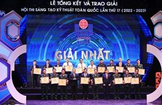
National awards honour 84 technical innovations
Eighty-four works were honoured with the 17th National Technical Innovation Awards at a ceremony held in Hanoi on April 23.
 Politics
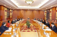
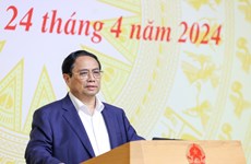
PM chairs meeting of national committee for digital transformation
Prime Minister Pham Minh Chinh chaired the eighth meeting of the National Committee for Digital Transformation on April 24, which aims to assess digital transformation efforts and development of the digital economy in recent times and discuss tasks and solutions for accelerating the work in 2024.
 Sci-Tech
Vietnam urged to build legal corridor for AI industry
Vietnam needs a policy on artificial intelligence (AI) to help this industry develop strongly, while minimising risks, according to insiders.
 Sci-Tech
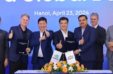
FPT, NVIDIA ink MoU to build 200 million USD AI factory
Vietnam’s tech giant FPT plans to build a 200 million USD artificial intelligence (AI) factory using Nvidia's graphics chips and software, as announced on April 23 in a comprehensive strategic partnership with NVIDIA.
 Sci-Tech
Ministry orders solutions to ensure information security
The Ministry of Information and Communications (MIC) has requested agencies, organisations, and enterprises to take measures to ensure cybersecurity and maintain the stable operation of their information systems during the celebration of the upcoming National Reunification Day (April 30) and May Day (May 1) and the 70th anniversary of the Bien Phu Victory (May 7).