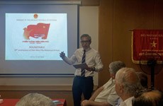
Vietnam seeks to enhance Geographic Information Systems
An international symposium on geographic information systems (GIS),
which are advanced forms of technological software used to analyse and
present geographical data, took place in the northern province of Thai
Nguyen on November 3-4.
An international symposium on geographic information systems (GIS),
which are advanced forms of technological software used to analyse and
present geographical data, took place in the northern province of Thai
Nguyen on November 3-4.
GIS is a computer system designed to capture, store, manipulate, analyse, manage and present all types of spatial or geographical data. Its applications and technologies are popular around the world in a number of fields, including national defence, the environment, healthcare, economic development, agriculture and forestry, tourism, urban and traffic management, natural disaster warning and climate change response.
Vietnam started researching GIS in the 1980s and a number of its top-rated tools are applied in agriculture and forestry planning, forest management, maps and surveys, land registry, information and transport management, tourism and climate change adaptation.
The University of Information and Communication Technology (UICT), part of the Thai Nguyen University, has been successful in integrating GIS into monitoring public buildings and making environment maps for agricultural production, amongst others.
At the symposium, scientists submitted more than 30 papers on GIS in remote sensing, information technology and communications, medical techniques, climate change response, and sustainable agriculture and forestry development.
On the occasion, the UICT announced the establishment of a GIS research centre which is expected to open up cooperation opportunities with scientists throughout the region.
The event was co-hosted by the UICT and Feng Chia University of Taiwan (China).-VNA


You should also see

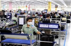
Investor confidence gains traction on improved business climate
Better investment climate, with simplified administrative producers and special incentives, has helped improve investor confidence, thus catalysing investments from a wider pool of both domestic and international investors for socio-economic development.

See more
 Society
Victims in southwestern border defence war commemorated
A ceremony was held in the town of Ba Chuc, Tri Ton district, the Mekong Delta province of An Giang on April 24 to commemorate people massacred by the Pol Pot genocidal regime in 1978 during the southwestern border defence war.
 Society
Quang Ngai: Traditional ceremony honours ancient Hoang Sa flotilla
An annual ceremony commemorating sailors of the historic Hoang Sa (Paracel) flotilla took place in the communal house of An Vinh village, Ly Son district, the central province of Quang Ngai, on April 24.
 Society
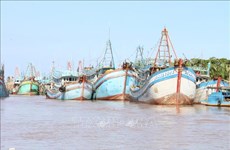
Ben Tre presses ahead with combating IUU fishing
The coastal Mekong Delta province of Ben Tre is pushing its efforts in preventing and combating illegal, unreported, and unregulated (IUU) fishing, preparing to work with the EC inspection team for the 5th time.
 Society
More officials investigated for suspected links with Phuc Son Group JSC
The police have officially started legal proceedings against Vice Chairman of the Vinh Phuc provincial People’s Committee Nguyen Van Khuoc and five others for their suspected involvement in the case at the Phuc Son Group JSC, Spokesman of the Ministry of Public Security (MPS) Lt. Gen. To An Xo said on April 23.
 Society
Dien Bien Phu Victory highlighted at symposium in Israel
The Vietnamese Embassy in Israel on April 23 hosted a symposium to commemorate the 70th anniversary of the Dien Bien Phu Victory (May 7, 1954-2024), with the participation of members of the Arab council of foreign relations, local scholars, and officials from Vietnamese representative offices in the country.