Another strong quake hits Indonesia
A 6.2-magnitude earthquake struck off Indonesia's coast, the
northern part of Sumatra island, in the evening of April 6, according
to the China Earthquake Networks Centre.
A 6.2-magnitude earthquake struck off Indonesia 's coast, the
northern part of Sumatra island, in the evening of April 6, according
to the China Earthquake Networks Centre.
The quake’s epicenter had a depth of about 20 km and was initially spotted to be at 1.7 degrees north latitude and 97.1 degrees east longitude.
However, the US Geological Survey said the earthquake was measured 5.8 on the Richter.
Neither immediate report of damages nor tsunami warning was issued.
Earlier, on the early morning of April 4, a quake with magnitude of 7.1 rocked Java island.
As sitting on the Pacific "Ring of Fire", where the meeting of continental plates causes high seismic activities, Indonesia and Sumatra in particular, are frequently prone to earthquakes and volcanic eruption./.


You should also see

Sun World Ba Na Hills - A fairyland in Da Nang
Ba Na Hills is a clear testament to the role of the private economy in the development of tourism in Da Nang as well as the city’s economy as a whole. Sun World Ba Na Hills was honoured in 2023 at the World Travel Awards as “Asia’s Leading Theme Park”.


See more
 World
World
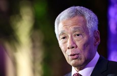
Singapore to have new Prime Minister on May 15
Singaporean Prime Minister Lee Hsien Loong will step down and hand over leadership to Deputy PM Lawrence Wong on May 15, the Singaporean PM's Office announced on April 15.
 World
World
Dangerous heat attacks many areas in Philippines
The heat index (HI) in nine areas of the Philippines was at “dangerous” level on April 15, according to the Philippine Atmospheric, Geophysical and Astronomical Services Administration (PAGASA).
 World
World
18th Singapore Maritime Week opens
The 18th Singapore Maritime Week (SMW) themed “Actions meet Ambition” opened on April 15 at the Suntec Singapore Convention and Exhibition Centre.
 World
World
Malaysia sets up clean energy exchange
The Malaysian government has agreed to establish the Energy Exchange Malaysia (Enegem) to facilitate cross-border sales of green electricity to neighbouring countries.
 World
World
Thailand promotes “soft power” through Songkran festival
The Thai government is actively promoting its "soft power" by organising the Maha Songkran World Water Festival 2024 with a series of events taking place over five consecutive days from April 11 to 15.