Atlas with hand-drawn maps offers readers visual feast
In the Vietnamese version of the book “Maps”, the drawing of Vietnam’s territory includes clear illustrations of Hoang Sa (Paracel) and Truong Sa (Spratly), showing the country’s sovereignty over these two archipelagoes in the East Sea.
The drawing of Vietnam’s territory includes clear illustrations of Hoang Sa (Paracel) and Truong Sa (Spratly), showing the country’s sovereignty over these two archipelagoes in the East Sea.
Hanoi (VNA) – The Lao dong (Labour) Publishing House and the Nha Nam Culture and Communications JSC have unveiled the book “Maps” by Polish authors Aleksandra Mizielinska and Daniel Mizielinski.
The 108-page book, translated into Vietnamese by Quynh Chi, is 27x37cm and features 52 completely hand-drawn maps.
What is special about this best-selling atlas?
“Maps”, a giant picture book and the world’s best-selling atlas for all ages, consists of 52 maps vividly illustrating geographical features and political boundaries while introducing famous destinations, typical fauna and flora, people, cultural events and other fascinating information about each region and country.
The book, considered a ticket for readers of all ages to travel around the globe, has been published in more than 30 countries and has sold over 3 million copies, becoming one of the best-selling books of maps in the world.
A large, hardcover and luxurious appearance, “Maps” is printed on high-end offset paper, and is a worthy addition to any cartophily’s collection.
 The cover of the book
The book comprises six maps from continents and 42 national maps. Outstanding features of each region and country such as destinations, costumes, cuisine, and festivals are all shown via cute and fun drawings.
Each map provides basic information about the area, population and language of the country and continent it shows.
“Maps” offers both children and adults a visual feast and a considerable amount of knowledge, inspiring young readers’ curiosity and desire for exploration. It also helps parents become closer to their children through joint reading.
Vietnam’s sovereignty over Truong Sa, Hoang Sa
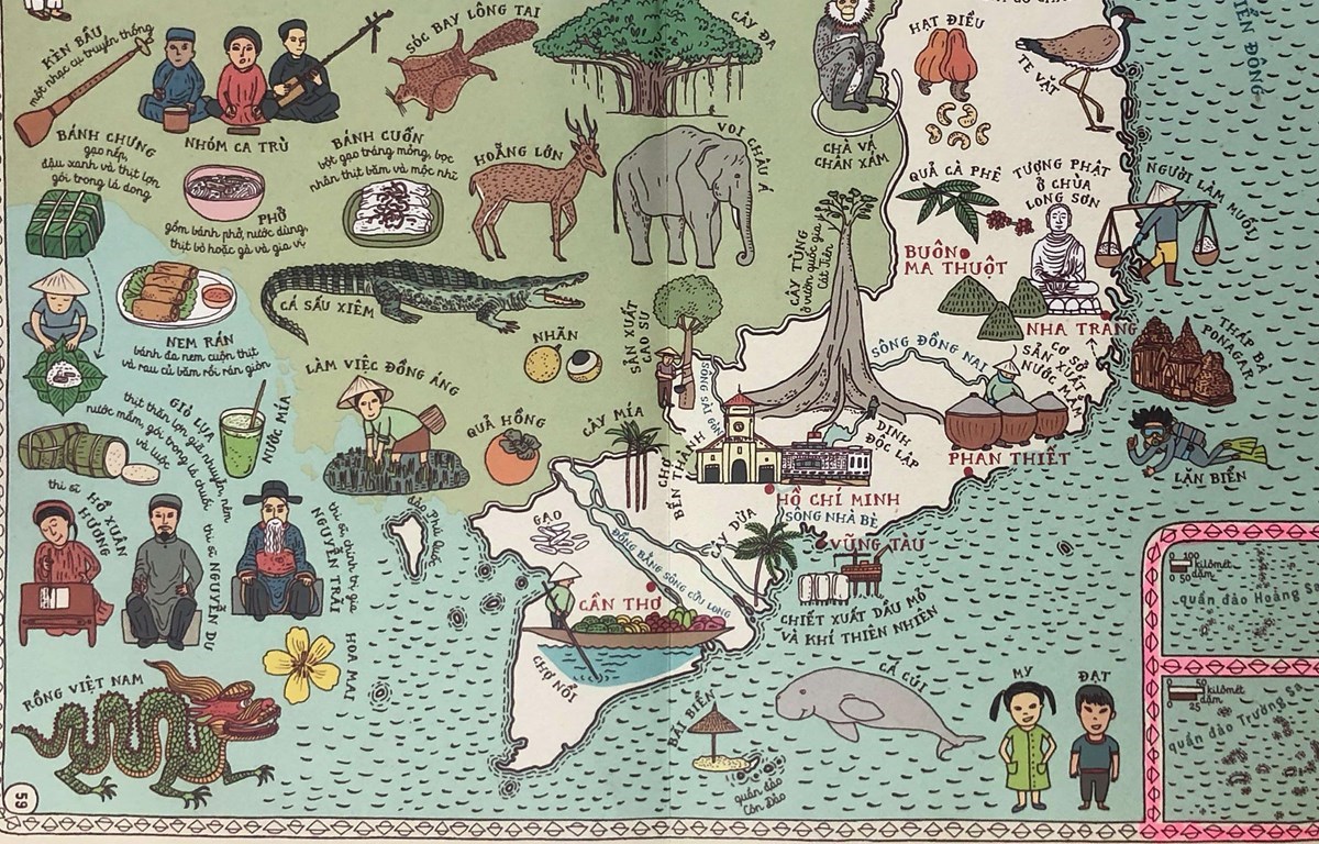
In this book, the Polish authors and editors draw a map of Vietnam in a highly vivid manner with illustrations of famous landscapes, animals, and traditional cultural identities.
More particularly, the hand-drawn map of Vietnam’s territory on pages 58 and 59 include clear images of Hoang Sa (Paracel) and Truong Sa (Spratly), affirming the country’s sovereignty over these two archipelagoes in the East Sea.
 On pages 58 and 59, the entirety of Vietnam’s territory is shown, including the Hoang Sa and Truong Sa archipelagoes.
“Maps” have been published in more than 30 countries, including Australia, Austria, Belgium, Brazil, Canada, Chile, China, Croatia, the Czech Republic, Ecuador, Egypt, Fiji, Finland, France, Germany, Ghana, Greece, Iceland, India, Italy, Japan, Jordan, Madagascar, Morocco, Mexico, Mongolia, Namibia, Nepal, the Netherlands, New Zealand, Peru, Poland, South Africa, Romania, Russia, Spain, Sweden, Switzerland, Tanzania, Thailand, the UK, and the US.
Book compiling process by the two young authors
It took Aleksandra Mizielinska and Daniel Mizielinski more than three years to create this “giant” book. After considerable research, they made a list of interesting information for children and selected the most fascinating details of each country.
Maps were drawn to scales based on published geographical maps. The young authors not only drew all details by hand but also designed text fonts in the book by themselves.
Their cute and colourful drawings have turned this book into an amazing picture encyclopedia and a best-selling geo-cultural atlas.
The book has earned its authors a number of big prizes, especially the Prix Sorcières of France and the Premio Andersen of Italy – two noble awards for works of children’s literature.
Aleksandra Mizielinska and Daniel Mizielinski graduated from the Academy of Fine Arts in Warsaw in 2007. In 2010, they were nominated for the Bologna Ragazzi Award and the IBBY Honour List, which are also in the sector of children’s publishing.
Their works have attracted not only children but also won the applause of adults.
“Maps” has been distributed nationwide and priced at 345,000 VND. Readers can also buy the book for 276,000 VND, including value-added tax, at Nha Nam bookstores. Each book is enclosed with one 55x81cm map of Vietnam./.
The 108-page book, translated into Vietnamese by Quynh Chi, is 27x37cm and features 52 completely hand-drawn maps.
What is special about this best-selling atlas?
“Maps”, a giant picture book and the world’s best-selling atlas for all ages, consists of 52 maps vividly illustrating geographical features and political boundaries while introducing famous destinations, typical fauna and flora, people, cultural events and other fascinating information about each region and country.
The book, considered a ticket for readers of all ages to travel around the globe, has been published in more than 30 countries and has sold over 3 million copies, becoming one of the best-selling books of maps in the world.
A large, hardcover and luxurious appearance, “Maps” is printed on high-end offset paper, and is a worthy addition to any cartophily’s collection.
The cover of the bookThe book comprises six maps from continents and 42 national maps. Outstanding features of each region and country such as destinations, costumes, cuisine, and festivals are all shown via cute and fun drawings.
Each map provides basic information about the area, population and language of the country and continent it shows.
“Maps” offers both children and adults a visual feast and a considerable amount of knowledge, inspiring young readers’ curiosity and desire for exploration. It also helps parents become closer to their children through joint reading.
Vietnam’s sovereignty over Truong Sa, Hoang Sa
In this book, the Polish authors and editors draw a map of Vietnam in a highly vivid manner with illustrations of famous landscapes, animals, and traditional cultural identities.
More particularly, the hand-drawn map of Vietnam’s territory on pages 58 and 59 include clear images of Hoang Sa (Paracel) and Truong Sa (Spratly), affirming the country’s sovereignty over these two archipelagoes in the East Sea.
On pages 58 and 59, the entirety of Vietnam’s territory is shown, including the Hoang Sa and Truong Sa archipelagoes.“Maps” have been published in more than 30 countries, including Australia, Austria, Belgium, Brazil, Canada, Chile, China, Croatia, the Czech Republic, Ecuador, Egypt, Fiji, Finland, France, Germany, Ghana, Greece, Iceland, India, Italy, Japan, Jordan, Madagascar, Morocco, Mexico, Mongolia, Namibia, Nepal, the Netherlands, New Zealand, Peru, Poland, South Africa, Romania, Russia, Spain, Sweden, Switzerland, Tanzania, Thailand, the UK, and the US.
Book compiling process by the two young authors
It took Aleksandra Mizielinska and Daniel Mizielinski more than three years to create this “giant” book. After considerable research, they made a list of interesting information for children and selected the most fascinating details of each country.
Maps were drawn to scales based on published geographical maps. The young authors not only drew all details by hand but also designed text fonts in the book by themselves.
Their cute and colourful drawings have turned this book into an amazing picture encyclopedia and a best-selling geo-cultural atlas.
The book has earned its authors a number of big prizes, especially the Prix Sorcières of France and the Premio Andersen of Italy – two noble awards for works of children’s literature.
Aleksandra Mizielinska and Daniel Mizielinski graduated from the Academy of Fine Arts in Warsaw in 2007. In 2010, they were nominated for the Bologna Ragazzi Award and the IBBY Honour List, which are also in the sector of children’s publishing.
Their works have attracted not only children but also won the applause of adults.
“Maps” has been distributed nationwide and priced at 345,000 VND. Readers can also buy the book for 276,000 VND, including value-added tax, at Nha Nam bookstores. Each book is enclosed with one 55x81cm map of Vietnam./.


You should also see

Top 500 fastest growing enterprises 2024 announced
A ceremony to announce the list of the top 500 fastest growing enterprises in Vietnam (FAST500) and Top 5 and Top 10 real estate - construction - building materials companies in 2024 was held by the Vietnam Report JSC in collaboration with VietNamNet newspaper on April 25.


See more
 Culture - Sports
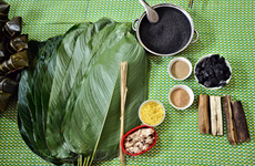
Black Chung cake: Culinary essence of Tay people in Bac Ha
Black Chung cake is a distinctive type of Chung cake made by the Tay ethnic people in Bac Ha district, Lao Cai province. Traditionally prepared only for Tet (the Lunar New Year), it has now gained popularity and has become a sought-after delicacy among tourists visiting the region.
 Culture - Sports
Film screenings, exhibitions to mark Dien Bien Phu Victory
The Vietnam Film Institute said on April 24 that it will coordinate with relevant agencies to organise exhibitions and film screenings in Dien Bien Phu city of the northwestern province of Dien Bien, and Ho Chi Minh City.
 Culture - Sports
Hanoi exhibition highlights Dien Bien Phu Victory
The Vietnam Military History Museum in Hanoi is hosting a photo exhibition on the Dien Bien Phu battle to mark the 70th anniversary of the Dien Bien Phu Victory (May 7, 1954-2024).
 Culture - Sports
Film week to mark 70th anniversary of Dien Bien Phu Victory
A film week is taking place in Dien Bien Phu city, the northwestern province of Dien Bien, from April 24 to 30 in celebration of the 70th anniversary of the Dien Bien Phu Victory (May 7, 1954 - 2024).
 Culture - Sports
Three Vietnamese female referees to officiate at U17 Women's Asian Cup finals
Three Vietnamese female referees have been invited to officiate at the 2024 AFC U17 Women’s Asian Cup finals, the Vietnam Football Federation (VFF) has announced.