Exhibition held on Vietnam’s ownership of Hoang Sa and Truong Sa
Exhibits affirming Vietnam’s sovereignty over Truong Sa (Spratly) and
Hoang Sa (Paracel) archipelagos are being showcased at an exhibition in
central Nghe An province’s Vinh city on May 26.
Exhibits affirming Vietnam’s sovereignty over Truong Sa (Spratly) and
Hoang Sa (Paracel) archipelagos are being showcased at an exhibition in
central Nghe An province’s Vinh city on May 26.
The display includes photos, documents, objects and nearly 100 maps, which were discovered earlier by both domestic and international researchers. The displayed materials are in Han (classical Chinese used in Vietnam), Nom (Vietnamese ideographic script), Vietnamese and French languages issued from the 17th to the outset of the 20 th centuries by the Vietnamese feudal states and the French government in Indochina (on behalf of the then Vietnamese state). They recorded the process of establishing, exercising and defending Vietnam’s sovereignty over the two archipelagoes.
Notably, maps published by China up to the beginning of 20 th century demonstrate China’s southernmost territory as Hainan Island without any mention of Hoang Sa and Truong Sa archipelagos.
In addition, World atlas Universel, drawn by the late cartographer Phillippe Vandermaelen and published in 1827, also describes Hoang Sa archipelago as belonging to Vietnam.
The exhibition aims to raise the public’s awareness as well as promote solidarity and encourage the responsibility of Vietnamese nationals in protecting and affirming national territory.
The exhibition will run until May 30.-VNA


You should also see

Cuban leaders appreciate Vietnam’s support, call for more investment
Deputy Prime Minister Tran Luu Quang had a meeting with First Secretary of the Communist Party of Cuba Central Committee and President of Cuba Miguel Diaz-Canel in Havana on April 15.


See more
 Culture - Sports
Sun Group's journey helps promote Da Nang's culinary essence globally
Following Hanoi and HCM City, Da Nang will be the third city to be awarded the "rising star" status by the Michelin Guide, with the partnership of Sun Group as the destination partner.
 Culture - Sports
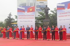
Russian province presents Lenin’s statue to Nghe An
The central province of Nghe An, the homeland of late President Ho Chi Minh, on April 16 received a statue of Vladimir Ilyich Lenin, a gift from the authorities and residents of Russia’s Ulyanovsk province.
 Culture - Sports
Vietnam book, reading culture day to feature numerous activities
The 3rd Vietnam Book and Reading Culture Day will kick off at the Temple of Literature in Hanoi on April 17, and be broadcast live on the Hanoi Radio and Television Station.
 Culture - Sports
Vietnamese taekwondo athletes welcomed ahead of Olympic Games Paris
Mayor of the French city of Bagneux Hélène Amiable hosted a local reception on April 15 for a delegation of eight young Vietnamese taekwondo athletes currently under training until April 16.
 Culture - Sports
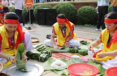
Rice cake cooking contest thrills visitors to Hung Kings Temple Festival
A cooking contest spotlighting Vietnam’s traditional rice cakes has stirred excitement in Phu Tho as part of the northern province’s ongoing signature Hung Kings Temple Festival.