Global warming threatens Ca Mau province
The southernmost province of Ca Mau was
among localities most vulnerable to climate change impacts, local and
foreign experts warned at seminar held here on April 25.
The southernmost province of Ca Mau was
among localities most vulnerable to climate change impacts, local and
foreign experts warned at seminar held here on April 25.
The seminar focused on ways to protect the province’s biosphere reserves and support local residents facing climate change challenges.
In recent years, the consequences of climate change on natural resources have clearly intensified and low-lying lands along the coastline are the most endangered, according to the experts.
However, the salt-marsh forest’s ecosystem can also help limit consequences of climate change.
In November last year, an investigation into the impacts of climate change was conducted on the east and west sides of Ca Mau province. Land erosion had been happening in both areas at the rate of 20 to 40 metres every year, it found.
Farmers who farm shrimp in the area say sea water levels have risen continuously over the past few years. In Ngoc Hien district, farmers say the yield has been reducing since 1994, in particular over the past three years.
The rise in sea levels has been a big concern of scientists and authorities in Ca Mau. According to statistics presented by Le Xuan Thuyen of HCM City Natural Science University, from 1998 to 2008, the average sea level in the province’s Nam Can district rose nearly 10cm over 21 years or an average of 16.8mm per year.
Katherine Muller-Marin, representative and Head of UNESCO Office in Hanoi, said the Ca Mau Cape World Biosphere Reserve was part of a biosphere reserve network in the world, so finding measures to protect the reserve from climate change should be taken immediately.
The contribution of the reserves to the world was not small and the capacity of mangrove forests to prevent and mitigate climate change impacts cannot be denied, she said, adding that people who live near the area and benefit from the resources must take part in protecting it.
“Education is key to protecting the area and the residents themselves from climate change and we must make sure the community takes part in the protection,” she said.
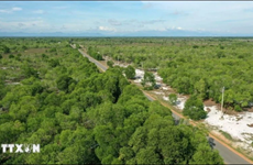
Ly Van Nhan of the Ca Mau Cape Biosphere Reserve Management Board, said in recent years, the impact of climate change in Ca Mau, the province with a 252km long coastline, had become clear.
The province was listed the second most vulnerable locality in the Mekong Delta to climate change, he said.
With a 0.7m rise in sea levels, 28 percent of the province’s land will be submerged and if the sea level rises 1m, Ca Mau will have 52 percent of its areas flooded, including the districts of Tran Van Thoi, Cai Nuoc, U Minh and Ca Mau city./.
The seminar focused on ways to protect the province’s biosphere reserves and support local residents facing climate change challenges.
In recent years, the consequences of climate change on natural resources have clearly intensified and low-lying lands along the coastline are the most endangered, according to the experts.
However, the salt-marsh forest’s ecosystem can also help limit consequences of climate change.
In November last year, an investigation into the impacts of climate change was conducted on the east and west sides of Ca Mau province. Land erosion had been happening in both areas at the rate of 20 to 40 metres every year, it found.
Farmers who farm shrimp in the area say sea water levels have risen continuously over the past few years. In Ngoc Hien district, farmers say the yield has been reducing since 1994, in particular over the past three years.
The rise in sea levels has been a big concern of scientists and authorities in Ca Mau. According to statistics presented by Le Xuan Thuyen of HCM City Natural Science University, from 1998 to 2008, the average sea level in the province’s Nam Can district rose nearly 10cm over 21 years or an average of 16.8mm per year.
Katherine Muller-Marin, representative and Head of UNESCO Office in Hanoi, said the Ca Mau Cape World Biosphere Reserve was part of a biosphere reserve network in the world, so finding measures to protect the reserve from climate change should be taken immediately.
The contribution of the reserves to the world was not small and the capacity of mangrove forests to prevent and mitigate climate change impacts cannot be denied, she said, adding that people who live near the area and benefit from the resources must take part in protecting it.
“Education is key to protecting the area and the residents themselves from climate change and we must make sure the community takes part in the protection,” she said.
Ly Van Nhan of the Ca Mau Cape Biosphere Reserve Management Board, said in recent years, the impact of climate change in Ca Mau, the province with a 252km long coastline, had become clear.
The province was listed the second most vulnerable locality in the Mekong Delta to climate change, he said.
With a 0.7m rise in sea levels, 28 percent of the province’s land will be submerged and if the sea level rises 1m, Ca Mau will have 52 percent of its areas flooded, including the districts of Tran Van Thoi, Cai Nuoc, U Minh and Ca Mau city./.


You should also see

PM urges village elders, citizens to help preserve cultural heritage
Prime Minister Pham Minh Chinh has asked village elders and chiefs, skilled artisans and reputable citizens to make greater efforts to preserve and promote tangible and intangible cultural heritage, which is the quintessence and core value of the nation.


See more
 Environment
Saigon Co.op ties up with Winrock International for waste circulation
Saigon Co.op signed an MoU with non-profit Winrock International in HCM City on April 12 to reduce environmental pollution by developing a waste circulation model, enhancing waste separation at source and raising the extended producer responsibility.
 Environment
Solutions proposed to tackle growing challenge of electronic waste
Vietnam faces a growing problem with electronic waste (e-waste), according to a study by the Hanoi University of Science and Technology's Centre of Science-Technology and Environment.
 Environment
Contest seeks innovative solutions to recycle plastic
The innovative solution contest 2024 was launched in Hanoi on April 12, aiming to seek solutions in the plastic circular value chain, especially new and creative solutions in improving the capacity to collect, process and recycle plastic packaging.
 Environment
Co To calls for actions to prevent plastic pollution in tourism activities
Co To island district in the northeastern province of Quang Ninh has asked local accommodation facilities and travel firms to apply environmental protection measures in tourism business activities to build an island free of plastic bags and other single-use items.
 Environment
Eight coastal localities get more support in forestry modernisation
The 4,040 hectares of forests planted and restored in the first phase of the World Bank (WB)-funded Forest Sector Modernisation and Coastal Resilience Enhancement Project will receive further care, as Prime Minister Pham Minh Chinh has issued a decision on the adjustment of the project investment, an official has said.