Historical documents on Hoang Sa, Truong Sa on display
Nearly 200 documents and maps affirming Vietnam’s sovereignty over
Hoang Sa and Truong Sa archipelagos are on display in the central
province of Ha Tinh.
Nearly 200 documents and maps affirming Vietnam’s sovereignty over
Hoang Sa and Truong Sa archipelagos are on display in the central
province of Ha Tinh .
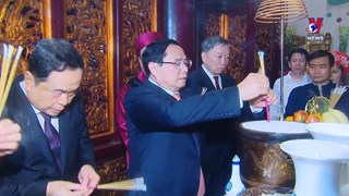
The week-long exhibition that opened on June 2 is part of the 2013 Vietnam ’s Sea and Island Week.
The exhibits include documents issued by the Vietnamese feudal states from the 17th century to the early 20th century, maps published by China and Western countries from the 16th century, and three atlases published in England , Germany and the US in the 1626-1980 period, which showed Hoang Sa and Truong Sa in Vietnam ’s territorial waters.
All the exhibits affirmed that Vietnamese states in history established and exercised their sovereignty over Hoang Sa and Truong Sa archipelagos. That was a long, continuous period recorded in historical documents of Vietnam and foreign countries.
Also on the display is a collection of sea shells taken by fishermen from Hoang Sa and Truong Sa sea area, showing vivid and significant evidence on Vietnam’s sovereignty over the two archipelago.
Addressing the opening ceremony, Deputy Minister of Information and Communications Do Quy Doan said the exhibition introduces 95 maps published by Vietnam, Western countries and China, 102 publications published in western countries and documents research. All documents attested that Vietnam established its sovereignty over Hoang Sa and Truong Sa from early stage.
The exhibition aims to raise public awareness of solidarity and responsibility among people, especially the youth, in protecting and affirming Vietnam’s sovereignty over the two archipelagos. It is also to affirm the importance of sea and islands in national construction and defence.-VNA


You should also see

PM visits police command centre, checks cultural centre construction in Phu Tho
Prime Minister Pham Minh Chinh visited the command and control centre of the Phu Tho police and examined the construction of this northern province’s house of culture and arts on April 18.


See more
 Culture - Sports
Vietnamese film wins highest award at Asian Film Festival in Italy
“Ben trong vo ken vang” (Inside the Yellow Cocoon Shell) by Vietnamese director Pham Thien An has won the best feature film award at the 21st Asian Film Festival held in Rome, Italy.
 Culture - Sports
AFC U23 Asian Cup: Vietnam crush Kuwait 3-1 in opener
The Vietnam U23 national football team started their journey at the 2024 AFC U23 Asian Cup with a 3-1 victory against Kuwait on April 17.
 Culture - Sports
Vietnam draw with Myanmar at 2024 AFC Futsal Asian Cup’s group stage
Vietnam drew 1-1 with Myanmar in their first match of Group A at the 2024 AFC Futsal Asian Cup on April 17.
 Culture - Sports
Vietnam’s No. 1 female badminton player qualifies for Paris Olympics
Female badminton player Nguyen Thuy Linh will be the 7th representative of Vietnam to compete in the Paris 2024 Olympics this summer.
 Videos
CNN names Vietnamese dumpling among world’s tastiest
Banh bot loc (Vietnamese tapioca dumpling), a specialty originating from the former imperial capital of Hue, has been selected as one of the world’s 35 tastiest dumplings by CNN.