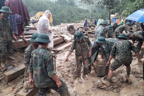
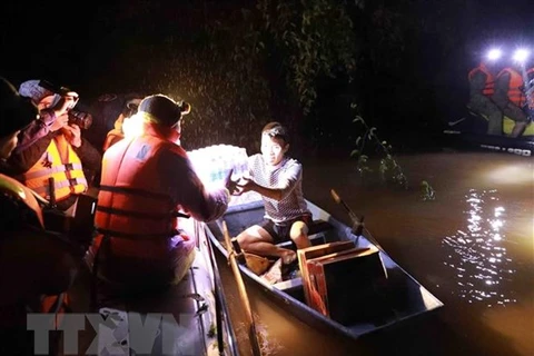
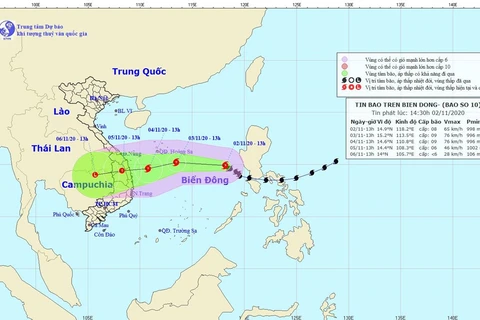
 Boats are common means of transport these days of people in the central province of Quang Binh. (Photo: VNA)
 Hanoi (VNS/VNA) - October left devastation for millions of people in central Vietnam.
In just one month, the region was hit by six storms and tropical depressions, something that was unprecedented according to Minister of Agriculture and Rural Development Nguyen Xuan Cuong.
The minister, who is also deputy head of the National Steering Committee on Natural Disaster Prevention and Control, said: “Provinces and cities in the central region have experienced two spells of heavy rain with record rainfall. The total rain volume in Ha Tinh, Quang Binh, Quang Tri and Thua Thien-Hue exceeded the historical toll in 1979 and 1999. Some places recorded rain of up to 800mm per day with total rainfall of more than 3,000 mm each period.”
In the first 20 days of October, many monitoring stations in localities from Ha Tinh to Quang Tri provinces recorded total rainfall three to five times higher than the annual average in the past 30 years. This explains why floodwaters rose very quickly.
Prolonged torrential rain together with severe floods starting on October 6 have led to the deaths of at least 157 people. Dozens of landslide victims are still missing and a village in Quang Nam was wiped out in a night by floods and landslides as villagers were buried in mud and soil.
Among those who have died in were soldiers and officers who were on rescue missions, workers of hydropower plants and local residents living in high-risk areas.
Le Cong Thanh, Deputy Minister of Natural Resources and Environment, said natural disasters last month in the central region and the whole country were more severe than in 1999 with four consecutive storms, of which the ninth storm Molave was the strongest in the past 20 years. But the damage was less devastating than 1999 thanks to the efforts of the whole community.
Dr Nguyen Xuan Tien, Deputy Director of the Hydrometeorology Station in the north-central region, said: “A series of rains and floods in the central region resulted from a complicated weather development. Rain and floods may become the ‘new normal’ in the future. Under the impact of climate change, rising sea levels make it difficult for water to escape to the sea and floods rise higher than before.”
Preparing scenarios
Severe weather conditions in the central region are clear signs of climate change that Vietnam is facing.
According to experts, planning accurate and detailed climate change scenarios is a sustainable solution to natural disasters.
Professor Phan Van Tan from the University of Science, Vietnam National University, said climate change scenarios could be applied for different purposes, but the ultimate goal is to develop plans and strategies to cope with climate change.
Responding to climate change includes climate change adaptation and mitigation. Climate change mitigation is a global issue and requires a consensus of the international community on reducing greenhouse gas emissions.
Adaptation to climate change is a local issue of which information from climate change scenarios is the basis for planning and strategy, he said.
Dr Tran Quang Hoai, deputy head of the National Steering Committee on Natural Disaster Prevention and Control, said learning from previous disasters, all localities, including those not in the path of storms, must be prepared for any possible scenario, especially when tropical depressions and storms are forecast to be around the East Sea.
“We have to mobilise all sources available on the spot. Waiting for rescue teams from outside the incident sites is not feasible in the condition of blocked traffic. Landslides last month in Thua Thien-Hue, Quang Tri and Quang Nam gave us that lesson.”
Deputy Minister of Agriculture and Rural Development Nguyen Hoang Hiep said soldiers and officers were very active in rescue missions but what a more professional force is needed. Authorised agencies have reported this problem to the Prime Minister.
The current system of coastal dykes is designed to cope with storms of level 9 and 10 maximum. “We lack the budget to build dykes with a bigger resistance capacity,” he said.
The deputy minister said many landslides recently occurred in geologically-stable areas not on landslide warning maps, so it is necessary to apply science and technology for better landslide prediction.
There are only more than 10 provinces with maps of landslide risks and deputy minister Hiep raised the issue at a Government press conference in October and suggested more investment in this work./.
VNA


