Overall planning for Mekong Delta adjusted
Prime Minister Nguyen Tan Dung has approved adjustments to an overall
development planning for the Mekong Delta through 2030, with a vision
towards 2050.
Prime Minister Nguyen Tan Dung has approved adjustments to an overall
development planning for the Mekong Delta through 2030, with a vision
towards 2050.
The changes of the 2009 plan will be made across the whole region, which is constituted by Can Tho city and other 12 provinces, and covers a combined area of nearly 40,605 square kilometres. The region had a population around 17.3 million in 2013.
The adjusted planning is required to include analysis and assessment of the region’s natural conditions and resources, ecological areas, national parks and environmental preservation zones.
Impacts caused by climate change, rising sea level and floods, along with socio-economic development situation and infrastructure systems must be considered.
Forecasts for regional development, physical structure and growth models and new national and global developmental circumstances must be identified.
Meanwhile, environmental changes resulting from socio-economic development and climate change, and potential and momentums for regional development are to be counted.
Regional growth model should ensure the area is adapted to climate change and Mekong river floods.
Earlier, the Ministry of Planning and Investment announced a master plan for the Mekong Delta Economic Zone.
The zone, consisting of Can Tho and the three provinces of Ca Mau, An Giang and Kien Giang, will be developed into a large-scale tourism and service centre in Vietnam, focusing on expanding Nam Can national tourism area.
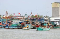
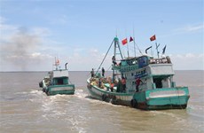
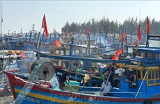
The Mekong delta is known as Vietnam’s largest granary and seafood depot with its rice and seafood outputs accounting for 53 percent and 60 percent of the country’s totals respectively.-VNA
The changes of the 2009 plan will be made across the whole region, which is constituted by Can Tho city and other 12 provinces, and covers a combined area of nearly 40,605 square kilometres. The region had a population around 17.3 million in 2013.
The adjusted planning is required to include analysis and assessment of the region’s natural conditions and resources, ecological areas, national parks and environmental preservation zones.
Impacts caused by climate change, rising sea level and floods, along with socio-economic development situation and infrastructure systems must be considered.
Forecasts for regional development, physical structure and growth models and new national and global developmental circumstances must be identified.
Meanwhile, environmental changes resulting from socio-economic development and climate change, and potential and momentums for regional development are to be counted.
Regional growth model should ensure the area is adapted to climate change and Mekong river floods.
Earlier, the Ministry of Planning and Investment announced a master plan for the Mekong Delta Economic Zone.
The zone, consisting of Can Tho and the three provinces of Ca Mau, An Giang and Kien Giang, will be developed into a large-scale tourism and service centre in Vietnam, focusing on expanding Nam Can national tourism area.
The Mekong delta is known as Vietnam’s largest granary and seafood depot with its rice and seafood outputs accounting for 53 percent and 60 percent of the country’s totals respectively.-VNA


You should also see

Dien Bien soldiers, youth volunteers meet in Hanoi
Nearly 300 soldiers and youth volunteers directly engaging in the Dien Bien Phu campaign 70 years ago looked back on the 56-day battle, the victory of which led to the signing of the Geneva Accords on ending the war and restoring peace in Indochina, at a meeting in Hanoi on April 23.


See more
 Videos
Youngsters join hands to preserve traditional outfits
With a desire to preserve and promote the cultural values of traditional outfits, youngsters from the Department of Journalism and Writing at the University of Hanoi Culture organised an arts programme reviving the clothing of the later Le Dynasty, attracting students from various universities around the capital.
 Society
Ten imprisoned for attempting to overthrow people's administration
The People’s Court of the Central Highlands province of Gia Lai on April 23 announced sentences on a group of individuals engaging in activities aimed at overthrowing the people's administration under provisions 1 and 2, Article 109 of the Criminal Code.
 Society
Regional workshop highlights cooperation against IUU fishing
A regional workshop on cooperative mechanisms to combat illegal, unreported, and unregulated (IUU) fishing convened in the central coastal city of Da Nang on April 23, with the participation of over 70 international and regional experts in fisheries law enforcement.
 Society
Ba Ria-Vung Tau strengthens measures to combat IUU fishing
The southern province of Ba Ria-Vung Tau has launched several specific tasks and measures to combat illegal, unreported, and unregulated (IUU) fishing.
 Society
Second banh mi festival slated for May
Ho Chi Minh City will host the second banh mi (Vietnamese sandwich) festival on May 17-19, aiming to promote the Vietnamese cuisine which has grown in popularity among foodies from around the globe.