PM gives nod to dyke planning along Red, Thai Binh Rivers
The Prime Minister has recently approved a planning scheme for flood prevention and dyke systems along the Red and Thai Binh Rivers.
 Part of Red River (Photo: vovworld.vn)
The two rivers encompass 15 cities and provinces – Hanoi, Hoa Binh, Ha Nam, Nam Dinh, Ninh Binh, Hung Yen, Hai Duong, Thai Binh, Hai Phong, Quang Ninh, Phu Tho, Vinh Phuc, Bac Ninh, Bac Giang and Thai Nguyen.
The scheme aims to help the localities take the initiative in preventing floods and storms, contributing to their socio-economic stability as well as national security and defence.
It will help relevant ministries, agencies and localities manage efforts against floods and storms, and outline investment plans for related projects until 2030 with a vision towards 2050.
Apart from forecasting the flood tide in these areas, the scheme also proposes anti-flood solutions, and how to effectively use river shores in line with the Dyke Law and relevant legal documents in service of national socio-economic development.
It defines prioritised items and estimates resources necessary for the realisation of the solutions.
During 2016-2030, efforts will be focused on planting administrative border markers at the dyke corridors, completing operational procedures of large reservoirs located at the upper parts of the rivers, upgrading dykes, afforestation plans, as well as infrastructure and equipment supporting the work.-VNA


You should also see

Top 500 fastest growing enterprises 2024 announced
A ceremony to announce the list of the top 500 fastest growing enterprises in Vietnam (FAST500) and Top 5 and Top 10 real estate - construction - building materials companies in 2024 was held by the Vietnam Report JSC in collaboration with VietNamNet newspaper on April 25.
See more
 Environment
Hoa Phat steel products certified to meet greenhouse gas inventory standard
Vietnamese steel giant Hoa Phat Group has announced that BSI - the UK's leading international certification organisation - certified ISO 14064-1:2018 standard and ISO 14067:2018 on greenhouse gas inventory for steel products of its subsidiary - Hoa Phat Dung Quat Steel JSC.
 Environment
Vietnam supports global agreement on plastic pollution
A delegation of Vietnamese negotiators joined those from 176 countries worldwide at the fourth session of the Intergovernmental Negotiating Committee (INC-4) on plastic waste in Ottawa, Canada, on April 23.
 Environment
Consultation workshop on Cambodia’s Funan-Techo canal held in Can Tho
The Vietnam National Mekong Committee (VNMC) on April 23 held a consultation workshop on Cambodia’s proposed Funan-Techo canal project which has raised concerns about potential impacts on the Mekong river.
 Environment
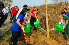
Up to 1,000 ban flowers planted at Dien Bien Phu battlefield relic sites
About 1,000 ban (Bauhinia variegate) flower trees were planted at relic sites such as A1 Hill, Him Lam resistance centre and De Castries Bunker at Dien Bien Phu battlefield relic complex in the northern province of Dien Bien on April 21.
 Environment
Vietnam acts to combat white pollution
The Vietnamese Government has issued a lot of policies, participated in various forums, and promoted international cooperation, demonstrating its activeness and affirming its determination to reduce plastic waste and join global efforts toward a planet without white pollution.