U Minh Thuong National Park biosphere ecotourism
 A corner of U Minh Thuong National Park. (Photo: VNA)
Hanoi (VNA) - Professionalizing ecotourism activities at U Minh Thuong National biosphere in the Mekong Delta province of Kien Giang is a focus to improve the park experience, with an array of innovative tourism products.
Recognised as the 2,228th Ramsar site of the world and eighth of Vietnam, the U Minh Thuong National Park world biosphere reserve holds huge ecotourism development potential.
Changes have been made in tourism activities in the site in the runup to this year as new types of tourism emerge.
From world biosphere reserve to ASEAN Heritage Park and Ramsar site
About 65km south western of Rach Gia city, U Minh Thuong National Park is one of the three conservation areas of a world biosphere reserve in Kien Giang province, and hardly any other conservation areas of wetlands in Southeast Asia can compare.
Formed and primarily straddling west of Ca Mau peninsula and bordering mangrove forests along the Gulf of Thailand, U Minh Thuong is a special brackish mangrove forest in Vietnam. It has even made its way onto the list of the most unique and rare forests in the world.
U Minh Thuong used to serve as a military base for the army during the country’s struggles against France and the US in the southwestern region and the Mekong Delta province of Kien Giang. There are a total of 31 historical and cultural relics in this area, with U Minh Thuong at the centre. At present, it is a special historical relic site in Kien Giang.
The national park was set up in accordance with the Prime Minister’s Decision No.11/QD-TTg dated November 14, 2002.
It is surrounded by a closed dyke system measuring about 60km in length. About 21,120ha of the park is in the communes of An Minh and Minh Thuan Bac of U Minh Thuong district, comprising 8,053ha of the core area with restricted zone of 7,838ha, 200-ha of ecosystem recovery and historical site conservation area and 15-ha of administrative area.
In October 2016, during the 19th session held in Paris, the United Nations Educational Scientific and Cultural Organisation (UNESCO) recognised the Kien Giang biosphere, including sea and island borders, as a world biosphere.
The area zoned off for the biosphere in Kien Giang, set up in May 2007, covers the districts of Phu Quoc, Kien Hai, Kien Luong and U Minh Thuong on a massive area of 1.1 million ha.
 Tourists at U Minh Thuong National Park.
(Photo: VNA)
In the alum-flooded Melaleuca forest ecosystem of the Mekong Delta, only the flora in the core zone of U Minh Thuong National Park has the characteristics of primaeval forests.
It is home to nearly 3,000ha of cajuput forests, which was the military base of the revolutionary troops during wartime.
With this characteristic, U Minh Thuong National Park is one of the two most important swampy forest areas remaining in Vietnam (with the other one being U Minh Ha).
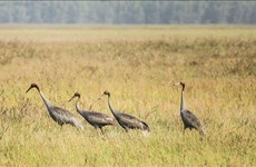
The cajuput ecosystem on peat land is one of great significance as the habitat of hundreds of wild animals, including birds, reptiles, amphibians and fish, to name but a few.
Although fauna in U Minh Thuong is not as diverse as that in other reserves in Vietnam, the area holds an important meaning to the alum-flooded Melaleuca forest ecosystem and the Mekong Delta.
U Minh Thuong boasts the most diverse flora in the delta, as alongside cajuput, it is home to more than 250 species of 84 genuses, as well as native plants.
Data since 1995 showed that U Minh Thuong biosphere houses up to 8,053 ha of pristine forests, of them some 3,009 ha dated back six millennia ago.
Its fauna comprises 32 species of 10 families and seven genuses, with various animals being listed as endangered ones of Vietnam and the world.
 An area in U Minh Thuong National Park. (Photo: VNA)
U Minh Thuong offers habitat for 72 rare animals and plants that are named in the 2007 Vietnam Red Book and the International Union for Conservation of Nature (IUCN) Red List of Threatened Species, particularly lutra sumatrana.
Over the past years, Kien Giang province has exerted efforts in the preservation and recovery of natural resources in peat land while ensuring original conditions of the ecosystem, along with diversity and outstanding values of population in U Minh Thuong National Park.
In 2012, the national park earned the title of the first ever ASEAN Heritage Park on peat land in Southeast Asia and the fifth ASEAN Heritage Park in Vietnam.
Three years later, it was recognised as the 2,228th Ramsar site of the world, and the eighth of its kind in Vietnam.
Achievements and success in the preservation and improvements of ‘green’ values at the national park helped fulfil five out of nine criteria of Ramsar Convention, which is an international treaty for the conservation and sustainable use of Ramsar sites (wetlands).
 A corner of U Minh Thuong National Park (Photo: VNA)
In 2021, the park welcomed more than 26,000 visitors. It was reopened to the public again on January 20 this year, as COVID-19 preventive measures were eased. After 45 days of reopening, the site received 11,000 visitors./.


You should also see
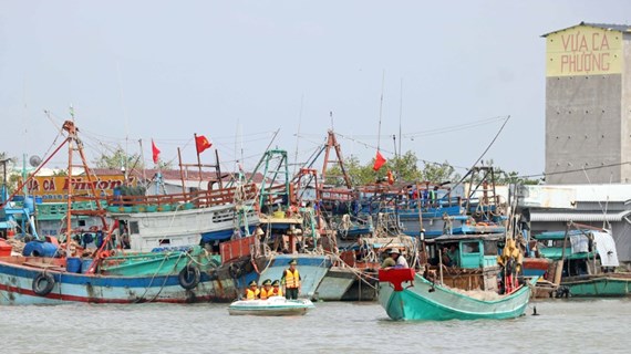
Government’s action programme cracks down on illegal fishing


See more
 Environment
Can Tho explores climate change cooperation with foreign countries
 Environment
Nghe An: Man captured for illegal wildlife transport
 Videos
Vietnam works to prevent biodiversity degradation
 Environment
Communication campaign calls for wildlife conservation efforts
 Environment