The East Sea issue under the light of international law
The East Sea issue is under the light of international law.
On March 23, 2011, Xinhua - the official news agency of China, published an article titled “The Nanhai sea dispute from the perspective of the international law of the sea” by scholars He Jian and Wang Ao from the Xiang Tan University, which not only asserted the so-called “sovereignty” of China in the East Sea but also accused Vietnam and other Southeast Asian nations of having “bent” the 1982 UN Convention on the Law of the Sea and fought against "China’s sovereignty” in the East Sea.
Vietnam News Agency is publishing an article titled “The East Sea issue under the light of international law” written by Hai Bien, a Vietnamese East Sea researcher, aiming to elaborate on the East Sea issue with respect to international law, particularly the 1982 UN Convention on the Law of the Sea.
1. Overview of the East Sea
The East Sea is a semi-enclosed sea in the Pacific Ocean, covering an area of over 3.5 million sq. km. It is bordered by nine coastal countries, namely Vietnam, China, the Philippines, Malaysia, Brunei, Indonesia, Thailand, Cambodia and Singapore. The East Sea is abundant in natural resources, especially oil, gas and marine resources. Recently, data suggest that the sea has huge reserves of natural hydrate. The sea is the second busiest maritime route in the world after the Mediterranean route, with 150 - 200 large-tonnage ships passing through its waters everyday. Imports and exports essential for such major economies as China, Japan, the Republic of Korea, Chinese Taiwan and Hong Kong, depend largely on this shipping route. Militarily, the East Sea is where naval fleets from many countries both inside and outside the region operate. All these factors have led to an inevitable and obvious situation that in the East Sea the interests of many countries are closely intertwined at different levels. Peace and stability in the East Sea directly affect peace and stability in the region and the world.
2. Maritime zones of the countries bordering the East Sea under the international law of the sea
The third United Nations Conference on the Law of the Sea (1967-1982) adopted the 1982 UN Convention on the Law of the Sea containing 320 articles and nine annexes. As an outcome of prolonged negotiations among different groupings of countries, the Convention constituted a fair and culminant package deal in the process of codification and progressive development of the international law of the sea. It has definitely established the legal regimes for different maritime zones under sovereignty and sovereign rights of coastal states, providing for the rights and obligations of the states in sea-related activities and setting up a series of important international mechanisms for the implementation of the Convention and settlement of sea disputes such as the International Tribunal for the Law of the Sea, the Conference of States Parties to the Convention, the International Seabed Authority and the Commission on the Limit of the Continental Shelf. To date, 161 countries and international organizations are parties to the Convention, among them seven countries bordering the East Sea, including Vietnam, China, Indonesia, Malaysia, the Philippines, Singapore and Brunei.
By applying the 1982 UN Convention on the Law of the Sea to the conditions of the East Sea, we can see several basic points below:
First, the countries bordering the East Sea have the sovereignty over their internal waters and territorial seas of 12 nautical miles which are measured from their baselines. It is notable that under the international law of the sea of the 1940s-50s, the territorial seas of the countries bordering the East Sea were just 3 nautical miles, beyond which were high seas. Thus, the Convention has enlarged the territorial seas of the countries bordering the East Sea by 9 nautical miles.
Second, each country bordering the East Sea has the sovereign rights over its exclusive economic zone of 200 nautical miles and continental shelf of at least 200 nautical miles. The breadths of both zones are measured from the baseline used to determine its territorial sea. When its actual continental shelf extends beyond 200 nautical miles, a nation bordering the East Sea may expand its continental shelf up to 350 nautical miles provided that it strictly complies with provisions and procedures set out in the 1982 UN Convention on the Law of the Sea .
Each country bordering the East Sea has full jurisdiction to explore and exploit natural resources in its maritime zones, especially the exclusive economic zone and continental shelf, to serve people’s livelihoods and national development. Each country bordering the East Sea has full powers to allow or disallow other countries to exploit natural resources in its maritime zones. At the same time, it is obliged to respect those sovereign rights of other neighbouring countries. In pursuance to the 1982 UN Convention on the Law of the Sea, the countries bordering the East Sea are concurrently obliged to respect other nations’ rights to freedom of navigation in and flight over their exclusive economic zones and the airspaces above these exclusive economic zones and continental shelves.
Third, under the 1982 UN Convention on the Law of the Sea, how should China’s signing of a contract with the Crestone Energy Corp. in 1992 on Vietnam’s Tu Chinh bank and official submission of its “U-shaped line” claim to the United Nations in May 2009, be viewed? The Tu Chinh bank completely lies within Vietnam ’s 200-nautical mile continental shelf on which Vietnam has assigned oil exploration blocks. China National Offshore Oil Corp’s signing of a contract in 1992 with the American Crestone Energy Corp. to explore oil and gas in the Tu Chinh bank area within Vietnam ’s 200-nautical mile continental shelf (which was called Wan'an Bei in Chinese) was a blatant violation of Vietnam ’s sovereign rights under the 1982 UN Convention on the Law of the Sea.
With regard to the “U-shaped line” or “nine-dotted line” claim, Chinese scholars all are clearly aware that at international seminars on the East Sea held in Hanoi (in 2009) and Ho Chi Minh City (in 2010) as well as other international seminars, French, Belgian, American and other foreign scholars clearly stated that the “U-shaped line” claim was dubious and groundless and that China should clearly explain the legal nature of sea areas within that “U-shaped line.” So far, both Chinese politicians and scholars have failed to provide satisfactory answers.
Proceeding from the provisions of the 1982 UN Convention on the Law of the Sea to which China is also a contracting party, it is apparent that this claim is absolutely contrary to provisions of the Convention. No provision in the Convention can justify this claim. Simply because the sea areas encircled by the “U-shaped line” cannot be the territorial sea or exclusive economic zone or continental shelf of China. These sea areas belong to the exclusive economic zones and continental shelves of Vietnam , the Philippines, Malaysia, Indonesia and Brunei. The irrational “U-shaped line” claim has seriously violated the sovereignty rights of the five ASEAN nations over their exclusive economic zones and continental shelves. Therefore, Vietnam , Malaysia, Indonesia and the Philippines have sent their diplomatic notes to the United Nations General Secretary to reject this claim.
The presentation of the mentioned irrational claim to the United Nations in 2009 and recent field activities to pursue this claim are further complicating the East Sea situation, causing great concerns among the world community. Countries involved in the East Sea dispute and also many other countries have expressed their displeasure with this claim.
3. Current disputes in the East Sea with respect to international law
There are two types of disputes concerning the East Sea – one over the overlapping continental shelves and economic exclusive zones and the other about sovereignty over the Hoang Sa (Paracel) and Truong Sa (Spratly) archipelagos.
a. Due to the narrow breadth of some areas in the East Sea, such as Bac Bo Gulf and the Gulf of Thailand, which is less than 400 nautical miles wide, parts of the economic exclusive zones and continental shelves of neighbouring countries overlap. As a result, there exist a number of disputes over the boundaries of the economic exclusive zones and continental shelves between the countries bordering the East Sea.
Relating to Vietnam , in the North, we have an overlapping area in the continental shelf and economic exclusive zone with China in the Bac Bo Gulf and a smaller area in the entrance to the Gulf. While to the South there are overlapping areas which are claimed by Vietnam , Cambodia, Thailand and Malaysia in the Gulf of Thailand. In the South of the East Sea, there is an overlapping area which is claimed by both Vietnam and Indonesia. The same overlapping areas are reported among other countries bordering the East Sea, such as between Malaysia and Thailand, between Thailand and Cambodia and between Indonesia and Malaysia. Sovereignty over these overlapping areas has been gradually settled by Vietnam and relevant countries in an amicable way in accordance with the 1982 UN Convention on the Law of the Sea.
b. The Hoang Sa and Truong Sa archipelagos consist of a series of tiny coral reefs and banks in the middle of the East Sea. At present, these two archipelagos are at the centre of complicated disputes between several countries bordering the East Sea. The sovereignty dispute over the Hoang Sa islands is between Vietnam and China while that over the Truong Sa is between five countries and six parties, including Vietnam , China, the Philippines, Malaysia, Brunei (Brunei claims sea areas) and Chinese Taiwan.
To settle territorial sovereignty disputes, international law has already come up with a principle to establish sovereignty - the principle of effective occupation and effective, continuous and peaceful exercise of state authority. This principle has been used by countries and international jurisdiction bodies in settling disputes over territorial sovereignty in the world. Some of the classical cases should be mentioned here were the dispute over the Palmas island between the USA and the Netherlands, the Minquiers and Ecrehous case between the UK and France, the case of the Clipperton island between Mexico and France or the case of Greenland between Norway and Denmark.
Applying the aforementioned principle to the cases of the Hoang Sa and Truong Sa Sa archipelagos, everyone clearly sees that the Vietnamese State has effectively occupied these two archipelagos for hundreds of years. Precisely speaking, the Vietnamese State has exercised its sovereignty over these archipelagos at least since the 17th century when they were not under the sovereignty of any country. Since then Vietnam has exercised effectively, continuously and peacefully its sovereignty over the two archipelagos.
There is ample of evidence of Vietnam 's sovereignty over the Hoang Sa and Truong Sa archipelagos. The first evidence is the maps of Vietnam in the 17th century. In these maps, these two archipelagos were called Bai Cat Vang (Golden Sandbank). And they were part of Binh Son district of Quang Ngai prefecture. The second evidence is contained in many ancient books of Vietnam , including Toan Tap Thien Nam Tu Chi Lo Do Thu (Route Maps from the Capital to Four Directions) in the 17th century, Phu Bien Tap Luc (Miscellaneous Records on the Pacification of the Frontier) in 1776, Ñai Nam Thuc Luc Tien Bien and Chinh Bien (the First Part of the Chronicles of Ñai Nam and the Main Part of the Chronicles of Ñai Nam) between 1844-1848 and others. These books wrote about Hoang Sa and how it was exploited by Hoang Sa brigades. In addition, many foreign ancient books and maps confirmed the two archipelagos belonged to Vietnam . The third evidence was that the Vietnamese feudal state had dispatched the Hoang Sa and Bac Hai brigades to exploit the two archipelagos in the name of the State (each brigade consisted of 70 members and their trip lasted for six months to catch tortoises, holothurians and precious snails and collect merchandises from sunken ships). There were specific rules set up by the State on selecting people to go to the archipelagos as well as awarding those who excelled in their exploitation duties. Those brigades were continuously operating during the Nguyen Lords’ period (1558-1783) to the Tay Son Dynasty (1786-1802) and the Nguyen Dynasty. The Nguyen Dynasty sent generals Pham Quang Anh (1815), Truong Phuc Si, Pham Van Nguyen and Pham Huu Nhat (from 1834-1836) to the Hoang Sa to survey and measure islands to draw a map of the archipelago. During their stay, the sailors also built temples and erected sovereignty markers there. In 2009, the Dang family in Ly Son Island, Quang Ngai Province, presented the Vietnamese State with a decree of the feudal dynasty confirming that the archipelago belongs to Vietnam .
Following its domination of Indochina, France, on behalf of Vietnam , continued to govern the two archipelagos by sending battleships to patrol the area to ensure security and prevent smuggling. The French authorities gave permissions to the Japanese to exploit guano on the archipelago. It also sent the De Lanessan ship there to conduct oceanographic, geological and biological research.
From 1930-1932, the French naval ships of Inconstant, Alerte, La Malicieuse and also De Lanessan were sent to the Hoang Sa archipelago on many occasions. In the early 1930s, French troops were deployed at the main islands of the Truong Sa archipelago (Truong Sa, An Bang, Ba Binh, Song Tu, Loai Ta and Thi Tu). Such activities were made public in the Gazette of the Republic of France published on July 26, 1933. In 1933, the General Governor of Indochina issued a decree incorporating the Truong Sa Archipelago into Ba Ria Province. France then separated the Hoang Sa archipelago from Nam Nghia Province and merged it into Thua Thien Province. France also dispatched a unit to a garrison in the Hoang Sa Archipelago.
After returning to Indochina, France demanded that troops of the Republic of China withdraw from some islands which they illegally occupied in 1946. The French troops replaced the Chinese and rebuilt meteorological and radio stations there.
In 1951, the San Francisco Conference discussed draft a Treaty of Peace with Japan. At that Conference, a proposal to return to China the Hoang Sa and Truong Sa archipelagos was put forward to add to the draft Treaty. Yet, the proposal was rejected. The rejection decision was approved with 46 votes in favour, three against and one abstention. At the Conference, the head of the Vietnamese delegation affirmed the Vietnamese State's long-standing sovereignty over the two archipelagos. This statement did not receive any objections and/or reservations from the floor.
In 1956 France transferred the Vietnamese southern territory to the Sai Gon administration. And from then on the Sai Gon administration sent troops to the two archipelagos and recognised them administratively, setting up in each archipelago a commune which was part of a mainland district. The Sai Gon administration built sovereignty markers and continued to manage the meteorological stations there.
Since the 1950s, the situation in the two archipelagos became more complicated. Taking advantage of the withdrawal of French troops from Indochina under the Geneva Accords in 1954, China occupied the eastern part of the Hoang Sa Archipelago in 1956. The Sai Gon administration vehemently opposed the occupation. In 1959, Chinese troops disguised as fishermen landed on the western part of the Hoang Sa archipelago. However, they were repelled by the troops of the Sai Gon administration and 82 Chinese "fishermen" were arrested. As for the western part of the Hoang Sa Archipelago, the Sai Gon administration continued to control them until 1974. In the same year, taking advantage of the fight between the army of the Sai Gon administration and the liberation fighters of the South Vietnam Provisional Government, China once again used navies to occupy the western part of the Hoang Sa archipelago. Following such event, both the Sai Gon administration and the South Vietnam Provisionary Government came out strongly against the illegal Chinese occupation.
In 1975, when the Sai Gon administration was overthrown by the revolutionary forces, the Vietnamese State overtook control of the islands within the Truong Sa archipelago and established the districts of Hoang Sa and Truong Sa . The naked truth is: by 1988 China had never occupied the Truong Sa Archipelago. On March 14, 1988, China started to use force to occupy some rocks on Vietnam ’s Truong Sa Archipelago. In the imbalanced fight on that day, 64 Vietnamese soldiers sacrificed their lives to protect the homeland's sovereignty.
In short, under the light of the international law, Vietnam has all historical evidence and legal foundation to confirm her sovereignty over the Hoang Sa and Truong Sa archipelagos. According to historical records, China only started to occupy the eastern part of Vietnam's Hoang Sa Archipelago in the 1950s. And in 1974, China resorted to military force to occupy the western part of the archipelago. On March 14, 1988, China again used military force to occupy some rocks of Vietnam's Truong Sa Archipelago.
4. Solutions to the East Sea issue
a. Issues concerning the East Sea are very complicated, important and sensitive to related countries. Marine resources in the East Sea are vital to the livelihood and daily life of hundreds of millions of people in the nine countries bordering the East Sea. Natural resources here are a necessary condition for the economic construction and development of related countries. Countries bordering the East Sea are stepping up activities in exercising their sovereignty and sovereign rights over their different sea areas respectively. At the same time, there are plentiful and diverse activities related to the East Sea (freedom and safety of navigation, combating crimes at sea, etc.) which are closely associated with the interests of different countries both inside and outside the region.
b. As a result, it is an objective requirement that all countries having activities in the East Sea should adhere to the common rules that the international community, including the countries bordering the East Sea, had worked hard to build – the 1982 UN Convention on the Law of the Sea. While applying the Convention in exercising its sovereignty and sovereign rights over its internal waters, territorial sea, exclusive economic zone and continental shelf as stipulated in the Convention, each country bordering the East Sea is obliged to respect the sovereignty and sovereign rights of other countries bordering the East Sea over their territorial seas, exclusive economic zones and continental shelves. This is an obligation that members of the United Nations must follow. This is also an obligation congruent with the 1982 UN Convention on the Law of the Sea and the 1969 Vienna Convention on the Law of Treaties.
It will be very unfair and irrational when a country bordering the East Sea arbitrarily constructed an ambiguous claim line that is contrary to the 1982 Convention, which violates the sea areas of neighbouring countries, creates a “disputed area” in the waters of neighbouring countries and then requested the affected countries to “put aside disputes to jointly exploit” their very own continental shelves. Similarly, an act of a country bordering the East Sea on its own discretion imposed a ban on fishing in other neighbouring countries’ exclusive economic zones is also a violation of the 1982 Convention. Such behaviours are clear violations of international commitments made by a member of the United Nations under the Charter of this body.
c. The existence of sovereignty disputes over the Hoang Sa and Truong Sa archipelagos as well as disputes over the overlapping continental shelves and exclusive economic zones is an objective fact. The settlement of such disputes, especially the sovereignty dispute over the two archipelagos, is difficult and complicated, but not impossible. As mentioned above, there are overlapping areas concerning the continental shelves and exclusive economic zones of Vietnam and China in the Bac Bo Gulf, and Thailand, Indonesia, Malaysia and Cambodia in the Gulf of Thailand. In the past, on the basis of the 1982 Convention and in the spirit of friendship, neighbourliness and respect for each other’s legitimate interests, Vietnam has settled the maritime delimitation lines with Thailand in the Gulf of Thailand, with China in the Bac Bo Gulf and the boundary of the continental shelf with Indonesia in the south of the East Sea. Other countries bordering the East Sea have also settled a number of sea disputes through joint efforts and on the basis of international law. Most recently, sovereignty disputes regarding some islets between Malaysia and Singapore, and between Indonesia and Malaysia were also settled by the International Court of Justice (ICJ)
Those experiences showed that sovereignty disputes over the Hoang Sa and Truong Sa archipelagos and disputes over the overlapping sea areas between countries bordering the East Sea will be amicably settled once international law, including the 1982 Convention, is respected, and peaceful means for solving disputes, which are stipulated in the Charter of the United Nations, are applied. Threat of force or threat to use force has been prohibited by international law. Threat of force or threat to use force will never constitute a proper method for resolving disputes in the East Sea.
d. Disputes related to the East Sea are obviously complicated. The path towards a final solution to these disputes that are acceptable to all concerned parties will be a bumpy and lengthy. That reality requires the parties involved to exert greater efforts to solve these issues. While seeking a fundamental and lasting solution to these disputes, the concerned parties should abide by the commitments prescribed in the Declaration on the Conduct of Parties in the East Sea (DOC), which was signed by ASEAN and China in 2002, in particular the commitment to restraining from any action that can further complicate the situation in the East Sea.
ASEAN member countries and China also need to increase their efforts and work together in building a more legally binding document which is a Code of Conduct in the East Sea. The document can be made in the form of a treaty, an accord, an agreement, or a memorandum of understanding (MOU) between ASEAN and China, which is signed by authorised representatives of ASEAN and China before being approved by competent agencies of ASEAN and China.
Respecting jus cogens principles of international law, the Charter of the United Nations and provisions of the 1982 UN Convention on the Law of the Sea, settling disputes by peaceful means, fully executing all the commitments contained in DOC, advancing toward the building of a Code of Conduct in the East Sea, and jointly working towards making the East Sea a body of peace, friendship and cooperation, are all key to resolving complex issues related to the East Sea./.


You should also see
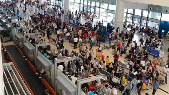
Airports to offer 9,000 domestic flights during upcoming holidays
Vietnamese airlines are expected to operate 9,000 flights on domestic routes to meet the travel demand during the upcoming National Reunification Day (April 30) and May Day (May 1) holidays, according to the Airports Corporation of Vietnam (ACV).

See more
 Politics
Vietnam upholds mobilisation, use, management of financing for sustainable development
State capital and private resources both play an important role in meeting financial needs for development and implementation of the sustainable development goals (SDGs), Minister Counsellor Nguyen Hoang Nguyen told the 2024 ECOSOC Financing for Development (FfD) Forum, held in New York from April 22-25.
 Politics
Vietnam treasures role of UNESCO: Foreign Minister
Vietnam always attaches importance to multilateral cooperation and the role of UNESCO, Minister of Foreign Affairs Bui Thanh Son told visiting President of the 42nd General Conference of UNESCO Simona-Mirela Miculescu in Hanoi on April 25.
 Politics
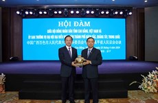
Cao Bang province, Baise city of China talk cooperation enhancement
The People’s Council of Cao Bang held talks with the Standing Committee of the People’s Congress of Baise city, the Guangxi Zhuang Autonomous Region of China, in the northern border Vietnamese province on April 25.
 Politics
Vietnam, Slovakia seek to promote delegation exchanges
Vietnamese Ambassador to Slovakia Nguyen Tuan has had a discussion with Chairman of the Foreign Affairs Committee of the Slovak National Council (Parliament) Marian Kery to seek measures to increase delegation exchanges between Vietnam and Slovakia in the coming time.
 Politics
☀️ Morning digest April 26
The following is a list of selected news summaries reported last night by the Vietnam News Agency.