Hanoi (VNA) – The National Centre for Hydrometeorological Forecasting has predicted that by 7 am on September 19, the current tropical depression in the East Sea will strengthen into a typhoon, reaching wind speeds of level 8 with gusts of level 10.
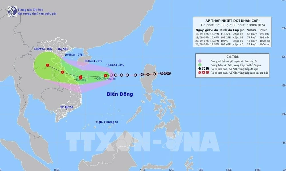
As of 7 am on September 18, the tropical depression was located at approximately 16.7 degrees North latitude and 113.5 degrees East longitude, about 220 kilometres east of the Hoang Sa (Paracel). The strongest winds near its centre reached level 7 (50-61 km/h), with gusts up to level 9. The depression is moving westward at a speed of about 15 km/h.
By 7 am on September 19, it is expected to move west-southwest at 20 km/h, intensifying into a typhoon. The storm's centre will be located about 210 kilometres east-southeast of Quang Tri province and 120 kilometres east of Da Nang city in the central region.
By 7 am on September 20, the typhoon is forecasted to shift west-northwest at 15 km/h, making landfall and gradually weakening as it moves over the Vietnam-Laos border, with winds dropping to level 6 and gusts to level 8.
In the following 48 to 72 hours, it will continue moving west-northwest at a speed of 10-15 km/h, weakening into a low-pressure area.
Due to the impact of the tropical depression, the northern part of the East Sea (including the Hoang Sa area) and coastal waters from Nghe An to Quang Ngai (including Ly Son, Cu Lao Cham, Con Co, and Hon Ngu islands) will experience strong winds at levels 6-7 and sea waves ranging from 2-4 metres high. Near the storm’s centre, winds could reach level 8 (62-74 km/h), with gusts up to level 10 (89-102 km/h) and waves as high as 3-5 metres, creating rough seas.
Vessels operating in these dangerous zones are at risk of thunderstorms, strong winds, and high waves. Coastal areas from Quang Binh to Quang Nam are advised to be vigilant against storm surges, high waves, and potential flooding in low-lying areas.
On land, from September 18 to 20, north central provinces are expected to have heavy to very heavy rainfall, with totals ranging from 100-300mm. From September 18 to 19, the Central Highlands and southern regions will experience moderate to heavy rain, with localised downpours of 40-80mm and some areas receiving over 150mm, mainly in the afternoon and evening.
In response, Quang Binh has imposed a ban on all maritime activities starting at 0:00 hour on September 19. Quang Nam authorities are actively implementing measures to ensure the safety of vessels and coastal activities, while preparing for potential flooding, landslides, and evacuations. In Quang Tri, the provincial People's Committee has issued an urgent dispatch to inform local authorities and residents to take precautions. As of September 18, all 2,280 fishing vessels in the province have been notified to seek shelter. Similarly, the Thanh Hoa People's Committee has directed local agencies to monitor and update information to minimise potential damage./.