Nha Rong Wharf, originally a major trading port in the South, was built in 1864 on the Saigon River. Nha Rong Wharf is where President Ho Chi Minh set off to find a way to save the country. Today, Nha Rong Wharf is a tourist attraction. (Photo: VNP/VNA)
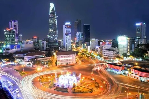
  Ho Chi Minh City by night (Photo: VNP/VNA)
  Cat Lai port located by the Dong Nai river is one of the key ports of Ho Chi Minh City’s port system. This is now the largest and most modern container port in Vietnam and is listed among 25 leading ports in the world. (Photo: VNP/VNA)
  Phu My cable bridge, inaugurated in 2009, connects District 2 with Districts 7 and 9. It is one of the routes connecting Thu Thiem new urban area and Phu My Hung urban area. (Photo: VNP/VNA)
  Construction of Metro line No. 1 from Depot Long Binh (District 9 and Binh Duong) to Ben Thanh in District 1. The work marks the development of Ho Chi Minh City. (Photo: VNP/VNA)
  Pham Van Dong Boulevard belongs to Ho Chi Minh City’s ring road No.1, starting from Tan Son Nhat airport to Linh Xuan crossroad, Thu Duc city. The city’s most beautiful inner route was put into operation in 2015. The 340 million USD route, invested by Korean GS Group, is the first project in Vietnam built in the Built-Transfer form by a foreign investor. (Photo: VNP/VNA)
  Tan Cang Sai Gon (Saigon Newport) Corporation is the most modern, professional and biggest container terminal operator in Vietnam with such services as cargo handling, logistics, maritime services, salvage, pilot, real estate, office building, civil and military, construction and multi-modal transportation services. (Photo: VNP/VNA)
  Cat Lai T-junction, the gateway to the city (Photo: VNP/VNA)
  The 17.8-kilometer long, 120-meter wide Nguyen Van Linh Boulevard begins at Huynh Tan Phat Street in District 7 and ends at National Highway 1A in Binh Chanh district. It has 10 lanes and 40 bridges and total investment of 100 million USD. It plays an important role to the development of the city’s southern region as it links to such key projects as Tan Thuan processing and exporting zone, Phu My Hung urban area, Hiep Phuoc industrial zone, Hiep Phuoc port, Phu My bridge and Thu Thiem new urban area. (Photo: VNP/VNA)
  District 2 in the city’s eastside boasts favourable conditions to form a new urban area. It is a traffic hub for road, inner railroad and waterway, connecting the city with Dong Nai, Binh Duong and Ba Ria-Vung Tau provinces. The newly urbanised district is expected to become a new trade and finance centre of the city in the future. (Photo: VNP/VNA)
  Ho Chi Minh City has the largest road system among urban areas in Vietnam with a total length of over 4,000 km. (Photo: VNP/VNA)
  A view of Ho Chi Minh City from Sai Gon river (Photo: VNP/VNA)
  District 1 is considered the busiest district, with the highest living standard in all aspects. Dong Khoi street and Nguyen Hue pedestrian street are the major business streets in the district. (Photo: VNP/VNA)
  The building of the municipal People’s Committee is a symbol of the city. The building features well-preserved French colonial architecture in a spacious garden landscape. Originally constructed as a hotel in 1898 by French architect Gardes, it now serves as a city hall and one of the city’s most iconic landmarks. (Photo: VNP/VNA)
 VNA