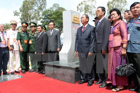
Prime Minister Nguyen Tan Dung and his Cambodian counterpart Hun Sen (L)
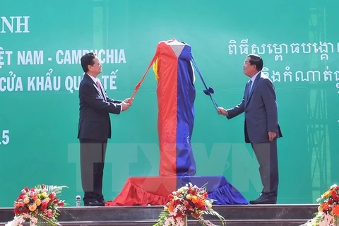
 Hanoi (VNA) – Prime Minister Nguyen Tan Dung and his Cambodian counterpart Hun Sen have recently inaugurated border markers No. 30 and No. 275, which marked the completion of planting all grand markers at 10 pairs of international border gates, basically forming the “backbone” of the border marker system along the two countries’ shared border line.
The event is of special significance as it testifies to the resolve of the two countries’ leaders and people to complete the demarcation of their shared land border as soon as possible, contributing to consolidating and enhancing the traditional friendship between the two countries.
In spite of the said resolve, several Cambodian politicians and officials, however, publically alleged that under the 2005 Supplementary Treaty which complements the 1985 Treaty on the Delimitation of National Boundaries ((hereinafter referred to as the 2005 Treaty), “Vietnam had agreed to negotiate” with Cambodia on the “delimitation” of a border area between Dak Dang and Dak Huyt streams in Quang Truc commune, Dak Rlap district, Dak Nong province, Vietnam (hereinafter referred to as the Bu Prang area). In addition, they also alleged that legally, the Bu Prang area should be part of Cambodia’s territory in accordance with Decree No. 1602 issued in 1914 by the Governor-General of Indochina (hereinafter referred to as Decree 1914).
In this regard, Mr Trinh Duc Hai, Doctor of Public International Law, an expert on territorial boundaries, told the Vietnam News Agency that the above-mentioned viewpoints are wrong in terms of law, history and practice. He affirmed that Vietnam’s sovereignty over the Bu Prang area is undoubtedly indisputable.
According to Dr. Trinh Duc Hai, Article 1 of the Treaty on the Principles of Settlement of Border Issues between Vietnam and Cambodia, signed on 20 July 1983 (hereinafter referred to as the 1983 Treaty) unambiguously provides for a fundamental principle on delimitation of the land border between the two countries, namely “On land border, the two sides regard the existing land boundary as illustrated on 1:100,000 scale maps published by the Geographic Service of Indochina, which were on side circulation before or closest to 1954 (26 pieces of map recognized and certified by the two sides attached), as international boundary between the two countries.
On the basis of the principles provided for under the 1983 Treaty, Vietnam and Cambodia signed the Treaty on the Delimitation of National Boundaries on 27 December 27 1985, attached with 26 pieces of the Bonne map scale 1:100,000 and 40 pieces of the UTM map scale 1:50,000, which are equally valid. Under Article 1 of the 1985 Treaty, the border section relating to the Bu Prang area has clearly been defined and delimited both in text and on map attached (piece No. 10, named 192W-POSTE MAITRE of the Bonne map, and piece No. 15, named DAK DAM of the UTM map).
In law and in fact, the Bu Prang area has always historically been part of Vietnam’s territory. It has long been under the country’s continuous and effective administration. Prior to the colonial period, the area was inhabited by ethnic minority groups whose graves and vestiges can be found in the area. During the occupation of the French, the area housed plantations of French and Vietnamese people.
A report made by Nam Ky (Cochin-China)-Cambodia Joint Commission for Land Border Delimitation in 1913 showed that the inhabitants in the area were mainly Stieng and Vietnamese.
After 1914, the Cochin-China colonial administration set up a number of military posts in the area in order to control the “three-border area.” After the three Indochinese countries regained their independence, in 1955 the Republic of Vietnam government conducted administrative reorganization, turning the “three-border area” into Bu Doc district with its township located in Bu Prang in Tuy Duc district, Quang Duc province.
After 1975, the Bu Prang area belongs to Tuy Duc district, Dak Lak province (now Dak Nong province) of Vietnam. A guard station was established at the Bu Prang border gate on May 20, 1975. After the national reunification day in 1975, Vietnam has continued to exercise its sovereignty and effective administration over the entire Bu Prang area.
Dr. Trinh Duc Hai affirmed that some Cambodian officials were not correct when they stated that Vietnam had agreed to continue negotiating with Cambodia on delimitation of the area between Dak Dang and Dak Huyt streams in accordance with the 2005 Treaty.
He said the 2005 Treaty’s primary aim is to confirm amendments to the 1985 Treaty. These amendments are expressly stated in Article II(1) of the 2005 Treaty and only deal with six border sections provided thereunder and river border sections in line with international practice, which do not include the border section relating to the Bu Prang area. As stated clearly in its preamble, the 2005 Treaty is not intended to provide for any redelimitation of any border section whatsoever.
Regarding the wording, on the basis of Article II (2) of the 2005 Treaty regarding the border section adjacent to the Bu Prang area of Vietnam, the two sides agreed only to continue their discussions (“poursuivre leurs discussions” in the French version of the Treaty, which is used as the reference in case there is different interpretation between the Vietnamese and Khmer versions), but not negotiations (“négociations” in French) about re-delimitation relating to the section Bu Prang.
As such, the content concerning the border section adjacent to the Bu Prang area as mentioned in Article II (2) of the 2005 Treaty should be construed and interpreted correctly as the two sides agreed to continue discussions on the border sector concerning the Bu Prang area, other than to continue any negotiations in order to re-delimit the border line relating to this area.
Based on the above-mentioned objective and the ordinary meaning of the terms of the 2005 Treaty, it goes without saying that the application of some elements, including the legal element that the colonial administration used to delimit the land border between Vietnam and Cambodia, should be understood as they are only applicable to six border sections as defined in Article II (1) of the 2005 Treaty, but not to the Bu Prang area, as some Cambodian officials wrongly interpreted.
Therefore, the invoking of the legal elements that the colonial administration used to delimit the land border between Vietnam and Cambodia in general and the 1914 Decree in particular to require “negotiation” over re-delimitation of the border section relating to the Bu Prang area is not in conformity with the object and purpose of the 2005 Treaty. At most, this Decree would only be taken into consideration during the course of the “exchange of views” on the border section relating to the Bu Prang area.
B esides, it is also necessary to stress that “legal elements that the colonial administration had used to demarcate the land border between Vietnam and Cambodia” may not be limited to the 1914 Decree. The legal elements are only one of the three equally important elements required to be taken into consideration. The other two elements include “la réalité de l’administration et de l’occupation effective de la population depuis plusieurs générations”, and “les caractéristiques topographiques”. In the case of the Bu Prang area, history has proved that Vietnamese inhabitants have long been living therein, and that the French colonial authorities and then the Vietnam’s authorities have without interruption exercised their complete sovereignty and administration thereover.
Dr. Trinh Duc Hai also stated that the interpretation by some Cambodian officials regarding the text of the 1914 Decree is also wrong. The relevant text of this Decree said that the border line concerning the Bu Prang sector followed the Dak Duyt “jusqu’à sa source”. Anyone who has been to Bu Prang may have noticed that the upper Dak Huyt is formed by two tributaries, namely the Dak Huyt to the South, and the Dak Dang to the North. In other words, the Dak Huyt has more than one stream. The Dak Dang was chosen by the French colonial authorities in 1914 as the stream boundary line between Vietnam and Cambodia. This has well been shown clearly on all the Bonne maps published by the Service géographique de l’Indochine (SGI) as from 1914 to 1954. In addition, it is worth mentioning that the 1914 Decree did refer to a “sketch map” annexed thereto. It, however, has not been found, although a lot of efforts were made by both Vietnam and Cambodia.
As mentioned above, the boundary line in the border section relating to the Bu Prang area following the Dak Dang stream has clearly and consistently shown on all the official maps published by the SGI between 1914 and 1954, and this serves as a solid proof that there may not be any other proper interpretation or “cartographical error” whatsoever committed when France drew such a boundary relating to the Bu Prang area on the maps, as some Cambodians interpreted the 1914 Decree.
Taking together the relevant wording of the 1914 Decree, the natural topographical characteristics of border section concerning the Bu Prang area, and all the maps published thereafter, it is without doubt that the boundary relating to the area always follow the Dak Dang stream, even under the terms of the 1914 Decree.
Since the signing of the 2005 Treaty, Vietnam and Cambodia have exchanged views about the border section relating to the Bu Prang area for a number of times in accordance with the 2005 Treaty. The Vietnamese side has provided solid legal and historical arguments to affirm its complete and indisputable sovereignty over the Bu Prang area. Meanwhile, the Cambodian side failed to show any proper evidence or arguments to support its viewpoint, beside referring in a general manner to the 1914 Decree.
In addition, consecutive governments of Cambodia since 1953 have publicly recognized and respected the border section relating to the Bu Prang area that follows Dak Dang stream as demonstrated in the Bonne map scale 1:100,000 issued by the Geographic Service of Indochina between 1933 and 1953 (piece 192W).
Furthermore, all the authorities in Cambodia before 1954 never opposed or challenged or complained to France about the marking of the boundary line relating to the Bu Prang area as drawn along Dak Dang stream on all Bonne maps published by the Geographic Service of Indochina before 1954. On the other hand, Cambodia had publicly requested that relevant countries respect the borderline as shown on the Bonne maps made by France. In this respect, some following instances, for the sake of clarity, should be mentioned:
- In 1964, 10 years after it gained independence from France, Cambodia, in its diplomatic note to the Security Council of the United Nations opposing the Vietnam Republic and the United States for their alleged bombing into Cambodian territory, attached the Bonne map scale of 1: 100,000 published by the Indochinese Geographical Service, including the map piece 192W-POSTE MAITRE, which is exactly identical to the one named the same annexed to the 1985 Treaty mentioned above.
- Also in 1964, Norodom Sihanouk, the Head of State of Cambodia, sent Nguyen Huu Tho, the President of the Provisional Revolutionary Front of South Vietnam a letter in which he requested that "For its part, Cambodia only asks for recognition of the current land boundary as shown on maps of common usage in 1954 ... "
- Constitution of the Kingdom of Cambodia in 1993 (proclaimed after the signing 1991 Paris Agreement on the Cambodia issue) also reaffirmed the territorial integrity of Cambodia as shown on the Bonne maps of scale 1:100,000 published in the period 1933-1953 and recognized internationally in the years 1963-1969.
In conclusion, the Bu Prang area has continuously been under Vietnam’s sovereignty in terms of legal, historical and always under the effective administration of Vietnam as recognized and respected by the consecutive governments of Cambodia. The border section relating to this area (which runs between Quang Truc commune of Dak Rlap district in Vietnam’s Dak Nong province and Dak Dam commune of O-reng district of Cambodia’s Mondolkiri province) has been delimited precisely and definitively as shown in piece 192W among the 26 Bonne map pieces, scale 1:100,000 attached to the 1983 and 1985 Treaties. That some Cambodian officials used the 2005 Treaty in order to use the 1914 Decree with a view to “re-negotiating” the delimitation of this border section is completely not in line with the border treaties between the two countries and does not benefit the long standing friendship and close neighborliness between the two countries - VNA