Dong Thap works to cope with erosion

The Mekong Delta province of Dong Thap has employed several measures to tackle increasingly erosion of river banks.
Dong Thap works to cope with erosion ảnh 1
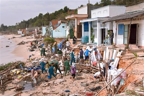
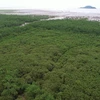
Erosion in Long Thuan commune, Hong Ngu district of Dong Thap (Photo: dantri.com.vn)

Dong Thap (VNA) – The Mekong Delta province of Dong Thap hasemployed several measures to tackle increasingly erosion of river banks.

From 2017 to early 2018, Dong Thap has recorded 36km of eroded areasalong the banks of the Tien and Hau Rivers, encroaching the mainland from0.5-30m. Compared to 2016, the eroded area increased by 8.3km in length,causing a loss of 13 hectares of land.

At the same time, sections with high risks of erosion increased to 66,10 sections more than in 2016, with an economic loss of 30 billion VND.

Currently, 2,400 local households are living in risky areas and needurgent evacuation.

Erosion has been seen in 25 communes, wards and towns in eight out of 12district of the province, mostly in Hong Ngu, Thanh Binh, Chau Thanh districtsand Cao Lanh city.

As of early 2018, 258 households were moved to safe places.

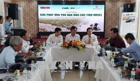
According to Nguyen Van Duong, Chairman of the People’s Committee ofDong Thap, the province has directed localities to keep a close eye on riskysites and plant alert signs, while strengthening communications on preventivemeasures among the community.

The province has mapped out a corridor of erosion to lay a foundationfor the evacuation of locals to safer places.

Meanwhile, it has constructed public infrastructure works inresettlement areas. More than 13,000 households have moved to the areas.

At the same time, Dong Thap has applied measures to fix eroded areas inThanh Binh district, while building dykes along the bank of Tien river with alength of 460m.

Dong Thap has proposed the addition of 54.7 billion VND (2.4 millionUSD) from the central budget in 2018 to support locals to evacuate to saferareas.

Alongside, the locality has asked for capital for the construction of 12residential areas for some 2,400 households in risky areas to resettle at acost of about 657 billion VND (28.9 million USD).

At a working session with representatives of13 Mekong Delta localities in Hanoi on May 9, Prime Minister Nguyen Xuan Phuc listedDong Thap, along with An Giang, Ca Mau and Bac Lieu as the most affected byerosion.

The PM decided to allocate part of the State budget to Mekong Delta localities,helping them build urgent and important facilities, and part of the country’sODA fund to form a climate change fund in the region.

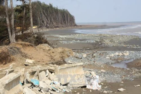
The Ministry of Agriculture and Rural Development reported that erosionhave occurred at 562 locations of river banks and seashores, with a totallength of 786km, of which 42 spots stretching 149km in specially dangerousconditions.

It needs about 6.99 trillion VND (307.56 million USD) to reinforce sucheroded locations, the ministry said.-VNA
VNA

See more

Vice Chairman of the Hanoi People’s Committee Nguyen Manh Quyen receives Sylvain Ouillon, Chief Representative of the French National Research Institute for Sustainable Development (IRD) in Vietnam (Photo: Hanoi Moi)

Hanoi strengthens ties with IRD to tackle air pollution

Vice Chairman of the Hanoi People’s Committee Nguyen Manh Quyen on November 6 received Sylvain Ouillon, Chief Representative of the French National Research Institute for Sustainable Development (IRD) in Vietnam, to discuss potential cooperation in air quality monitoring and pollution reduction in the capital city.

Houses inundated by storm-triggered flooding. (Photo: VNA)

Central, Central Highlands localities race to recover from Storm Kalmaegi

According to Vietnam Disaster and Dyke Management Authority (VDDMA), the storm left five people dead and six injured. As of 7 a.m. on November 7, 52 houses had collapsed and 2,593 others were damaged or unroofed, including 2,412 in Gia Lai province. Nine fishing vessels were reported sunk.

High waves in Ly Son island, Quang Ngai province due to Typhoon Kalmaegi. (Photo: VNA)

Central, Central Highlands localities respond to Typhoon Kalmaegi

As Typhoon Kalmaegi, the 13th storm to hit the East Sea this year, intensifies and heads toward Vietnam’s central coast, localities across the central and Central Highlands regions, including Dak Lak, Lam Dong, Da Nang and Quang Ngai, have activated their highest-level disaster response measures to ensure the safety of people and property.

A map released at 2pm on November 4, tracking the path of Typhoon Kalmaegi (Source: National Centre for Hydro-Meteorological Forecasting)

PM urges proactive measures in response to Typhoon Kalmaegi

As Typhoon Kalmaegi is expected to enter the East Sea on the morning of November 5, with sustained winds of level 13–14 and gusts reaching level 17, Prime Minister Pham Minh Chinh has ordered ministries, sectors, and local authorities to implement the highest-level response measures to protect lives and minimise damage.

Residents in the buffer zone of the UNESCO-recognised Western Nghe An Biosphere Reserve (Photo: VNA)

Vietnam's World Biosphere Reserves eye to become ideal destinations

Vietnam's World Biosphere Reserves have truly become a rendezvous for integration, cooperation, and the exchange of information and experiences among countries and international organisations in the field of conservation and sustainable development, as well as an ideal destination for domestic and international tourists, heard a conference in the central province of Khanh Hoa on November 3.

Heavy rain and prolonged flooding have caused deep inundation, making transportation difficult. (Photo: VNA)

Heavy downpours, floods leave 37 dead, five missing

In addition, floods have submerged and damaged 7,897 hectares of paddy and crops, and 64,356 livestock and poultry have died or been swept away. Across the nation, 103 houses have collapsed or been washed away, 451 others damaged, and 12,676 flooded.

Heavy rain causes severe flooding on many roads across Nghe An province on November 3. (Photo: VNA)

Storm Kalmaegi intensifies, authorities warn of flooding and landslides

From early November 3 to late November 4, areas from Ha Tinh to Da Nang and eastern Quang Ngai are expected to experience very heavy rainfall — 200–300mm on average, and up to 600mm in some places. Areas in Ha Tinh province, the northern part of Quang Tri province, and the eastern part of Quang Ngai province may see 100–200mm of rain, with localised totals exceeding 350mm.

Farmers harvest rice in the Mekong Delta. (Photo: VNA)

Agricultural sector to cut at least 15% greenhouse gas emissions by 2035

The project on low-emission crop production for the period for 2025-2035, with a vision extending to 2050, focuses on high-emission crops such as rice, cassava, sugarcane, coffee, and bananas. It aims to pilot at least 15 farming models nationwide that are ready for carbon credits and meet international standards.

Soldiers transport rice to distribute to flood-hit residents on October 31. (Photo: VNA)

PM orders urgent support for flood-hit localities

To ensure residents' safety and prevent hunger and disease outbreaks, the PM asked the Minister of Finance to immediately allocate rice from national reserves to flood-hit communities, based on requests from provincial authorities, including Quang Ngai. Implementation results should be reported to the PM by October 31.

High tides hit many areas in Can Tho city. (Photo: VNA)

JICA provides over 9 billion VND to help Can Tho improve drainage system

Japan's Fukuoka city will share its experience and advanced technologies to help Can Tho tackle three major issues: flood damage and untreated wastewater discharge, inefficient management of wastewater treatment plants, and low public awareness about connecting private drains to public systems.