The technology is available for flood-mapping in Vietmam but little progress has been made due to a lack of capital to pursue the project, a scientist has said.
Professor Nguyen Dinh Duong, head of the Institute of Geography 's Department of Environmental Information Study and Analysis pointed to the small number of existing flood maps, which had limited reliability and value, noting that no single flood forecasting map had yet been made.
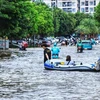
The higher frequency and growing intensity of flooding in recent years demanded that a tool be developed to support disaster management efforts, he added.
The latest floods in the central region last fall killed 198 people, left 35 missing and 197 injured and caused property losses estimated at 13.5 trillion VND (642.8 million USD).
"The problem we are now facing is not a lack of modern technologies, as in many other cases but, at heart, a lack of robust supporting policies to boost the application of such technologies," Duong told Vietmam News.
The percentage of the gross domestic product dedicated to flood control in provinces affected by the problem was miniscule, he said.
"It's been a great challenge to persuade local authorities, especially those in places where floods often wreak havoc, to invest in technology in general and to move flood mapping in particular up the priority list. There always seems to be more urgent things."
Flood status maps were easier to create than flood forecast maps because the only input data required for the mapping model were the inundation areas and depths, said the Director of the Hydrology and Environment Centre, La Thanh Ha.
Forecast maps were of greater value, but required additional resources from other related fields, including local rainfall and river flow data, to be able to provide accurate information about expected flood conditions, Ha said.
A lack of topographic maps was a major obstacle, she said, noting that the Mekong Delta was one of the few regions in the country with a topographic map to the scale 1:5,000.
National Remote Sensing Centre Director Nguyen Xuan Lam said remote sensing images would be of great help to flood mapping, but Vietnam lacked its own remote sensing satellites and had to acquire images from other countries.
The country was working to build its first remote sensing satellite, which was expected to launch in 2014, giving researchers remote sensing imagery within hours of the occurrence of flooding instead of days. /.
Professor Nguyen Dinh Duong, head of the Institute of Geography 's Department of Environmental Information Study and Analysis pointed to the small number of existing flood maps, which had limited reliability and value, noting that no single flood forecasting map had yet been made.
The higher frequency and growing intensity of flooding in recent years demanded that a tool be developed to support disaster management efforts, he added.
The latest floods in the central region last fall killed 198 people, left 35 missing and 197 injured and caused property losses estimated at 13.5 trillion VND (642.8 million USD).
"The problem we are now facing is not a lack of modern technologies, as in many other cases but, at heart, a lack of robust supporting policies to boost the application of such technologies," Duong told Vietmam News.
The percentage of the gross domestic product dedicated to flood control in provinces affected by the problem was miniscule, he said.
"It's been a great challenge to persuade local authorities, especially those in places where floods often wreak havoc, to invest in technology in general and to move flood mapping in particular up the priority list. There always seems to be more urgent things."
Flood status maps were easier to create than flood forecast maps because the only input data required for the mapping model were the inundation areas and depths, said the Director of the Hydrology and Environment Centre, La Thanh Ha.
Forecast maps were of greater value, but required additional resources from other related fields, including local rainfall and river flow data, to be able to provide accurate information about expected flood conditions, Ha said.
A lack of topographic maps was a major obstacle, she said, noting that the Mekong Delta was one of the few regions in the country with a topographic map to the scale 1:5,000.
National Remote Sensing Centre Director Nguyen Xuan Lam said remote sensing images would be of great help to flood mapping, but Vietnam lacked its own remote sensing satellites and had to acquire images from other countries.
The country was working to build its first remote sensing satellite, which was expected to launch in 2014, giving researchers remote sensing imagery within hours of the occurrence of flooding instead of days. /.