An exhibition displaying historical documents affirming Vietnam’s sovereignty over Hoang Sa (Paracel) archipelago opened in central Da Nang city on April 29.
On display are documents, maps and scientific research relating to Hoang Sa archipelago, affirming Vietnam ’s indisputable sovereignty over Hoang Sa and Truong Sa (Spratly) archipelagos.
They include maps published in England, Germany, Australia, Canada, the US and Hong Kong (China) in the 1626-1980 period, which were presented to the Hoang Sa district People’s Committee by Tran Thang, an overseas Vietnamese in the US.
In addition, maps indicating that China ’s southernmost territory is Hainan Island while Hoang Sa, Truong Sa archipelagos are in Vietnam ’s territorial waters are on display.
Three atlases, published by China in 1908, 1919 and 1933, are being exhibited to show that Hoang Sa and Truong Sa did not historically belong to China .
All the historical documents and maps exhibited will be translated in English, and a group of interpreters will be available to help foreigners learn more about the exhibits.
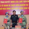
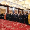
The opening ceremony of the event, entitled “Hoang Sa belongs to Vietnam - historical evidence”, saw the presence of those who once lived, worked and defended national sovereignty on the country’s Hoang Sa archipelago.
Dang Cong Ngu, Chairman of the Hoang Sa island district’s People’s Committee, said the exhibition is an important event as it will help foreign friends understand more about Vietnam ’s sovereignty over Truong Sa and Hoang Sa, and help protect the truth and international law towards a peaceful East Sea .
The exhibition will run until May 15.-VNA
On display are documents, maps and scientific research relating to Hoang Sa archipelago, affirming Vietnam ’s indisputable sovereignty over Hoang Sa and Truong Sa (Spratly) archipelagos.
They include maps published in England, Germany, Australia, Canada, the US and Hong Kong (China) in the 1626-1980 period, which were presented to the Hoang Sa district People’s Committee by Tran Thang, an overseas Vietnamese in the US.
In addition, maps indicating that China ’s southernmost territory is Hainan Island while Hoang Sa, Truong Sa archipelagos are in Vietnam ’s territorial waters are on display.
Three atlases, published by China in 1908, 1919 and 1933, are being exhibited to show that Hoang Sa and Truong Sa did not historically belong to China .
All the historical documents and maps exhibited will be translated in English, and a group of interpreters will be available to help foreigners learn more about the exhibits.
The opening ceremony of the event, entitled “Hoang Sa belongs to Vietnam - historical evidence”, saw the presence of those who once lived, worked and defended national sovereignty on the country’s Hoang Sa archipelago.
Dang Cong Ngu, Chairman of the Hoang Sa island district’s People’s Committee, said the exhibition is an important event as it will help foreign friends understand more about Vietnam ’s sovereignty over Truong Sa and Hoang Sa, and help protect the truth and international law towards a peaceful East Sea .
The exhibition will run until May 15.-VNA