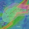
VNREDSat-1, Vietnam’s very first remote sensing satellite (Photo: airbus.com)
 Using the VNREDSat-1 imagery and geographic information system (GIS) application, the project completed digital databases on the ecological, soil and climate conditions of the country and the Tay Nguyen Central Highlands, as well as a database to calculate greenhouse gas emissions, while setting up maps for land cover in Tay Nguyen localities and its changes.
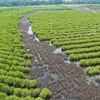
High-resolution images provided by VNDREDSat-1 help improve the accuracy of land-cover mapping, thus improving the reliability of calculation of the greenhouse gas emissions in different areas.
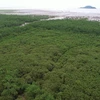
 A high-resolution image provided by VNDREDSat-1 (Photo: earth.esa.int)
 The project showed that changes in forest reserves, biomass, and land uses have great impacts on greenhouse gas emissions in energy and agriculture, 20 percent of which is contributed by deforestation and changes in land use.
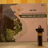
The Central Highlands, which accounts for 35.7 percent of the country’s forest areas, absorbs 50 percent of the nation’s total carbon dioxide emissions, the project reveals./.
VNA