 Deputy Prime Minister Trinh Dinh Dung, head of the committee, said the storm would enter the country during the National Day holidays. (Photo: VNA)
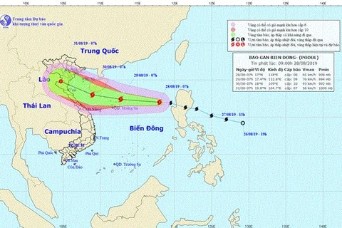
 Hanoi (VNA) - Tropical storm Podul is projected to make landfall on a stretch from central Thanh Hoa to Quang Binh provinces at noon on August 30 with heavy rains are expected in the northern and central regions from August 29 afternoon to September 2.
By 1:00 on August 29, the tropical storm was located to the northeast of Vietnam’s Hoang Sa (Paracel) archipelago, packing winds of 75-90 kilometres per hour, according to the National Hydro-Meteorological Forecasting Centre.
Podul is moving westwards at a speed of 20-25 kilometres per hour and is expected to gain further strength over the coming days.
The storm, the fourth of its kind entering the East Sea this year, is forecast to weaken into a tropical depression after hitting the mainland on August 31.
In a related move, the Central Steering Committee on Natural Disaster Prevention and Control has asked its sub-committees, relevant ministries and sectors to brace for tropical storm Podul.
Deputy Prime Minister Trinh Dinh Dung, head of the committee, said the storm would enter the country during the National Day holidays so it was necessary for tourists to pay attention to weather forecasts.
“These are issues that ministries, branches and localities should pay utmost attention to while dealing with the storm. We cannot be negligent because there are only two days left before the storm landing," Dung said at a meeting held on August 28 to discuss measures to cope with the tropical storm in the East Sea.
Minister of Agriculture and Rural Development Nguyen Xuan Cuong said areas forecast to have heavy rain were the northern mountainous provinces, the Red River Delta, the north-central region and the Central Highlands. These areas have recently been experienced damage to soil structure.
If heavy rains continued to occur in these areas, it was necessary to prepare for flash floods and landslides, he said.
“These areas have many reservoirs, including degraded and small hydropower reservoirs, so localities must prepare for possible incidents," said Cuong.
The Border Guard High Command said as of August 28 afternoon, the command had provided information about the storm’s direction and progress to 70,000 vehicles and 300,000 fishermen. However, nearly 800 ships with over 5,000 people were operating in dangerous areas.
The same day, the Central Steering Committee on Natural Disaster Prevention and Control sent urgent messages to 13 provinces and cities to make plans the storm.
The concerned ministries and authorities of the localities in the path of the storm were asked to take necessary measures to ensure the safety of local residents and their properties.
The vessels operating at sea will be informed of the storm so that they can escape or stay away from the danger zone.
Local authorities were asked to review and be ready to evacuate residents from areas at high risk of flash floods.
“Over recent years, the damage caused by floods is much higher after the storm than when it lands, so we need to be fully prepared to deal with the storm for many days," the Deputy PM said.-VNA
VNA


