Typhoon Saola causes strong wind at sea

The strongest wind near the eye of Typhoon Saola reaches 184-201km per hour, as the storm is moving deeper into the northeastern waters north of the East Sea, causing rough seas.
Typhoon Saola causes strong wind at sea ảnh 1
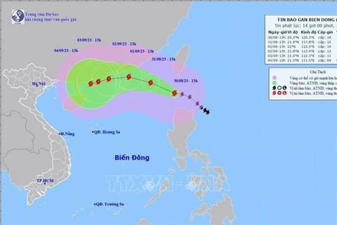
The movement of typhoon Saola (Source: National Centre for Hydro-Meteorology Forecasting)
Hanoi (VNA) - The strongest wind near the eyeof Typhoon Saola reaches 184-201km per hour, as the storm is moving deeper into thenortheastern waters north of the East Sea, causing rough seas.

Entering the waters on August 30, it is the third stormhitting the area this year. According to the National Centre for Hydro-MeteorologyForecasting, at 4am on August 31, Saola’s eye was at 21 degrees north latitudeand 118.5 degrees east longitude, about 510 kilometers southeast of Hong Kong(China). The typhoon is moving west-northwest at a speed of about 10-15km perhour.

It is predicted to continue moving in the same direction onSeptember 1 at 10-15km per hour, then west on September 2 and west-southwest onSeptember 3 at 10km per hour. At 4am on September 3, its eye will be at 21.3 degrees north latitude and 112.1 degrees east longitude on thesouthwest waters of Guangdong (China).

The typhoon is forecast to maintain the west-southwestdirection with a speed of 5-10km per hour in the following 72 to 120 hours. Itsintensity is likely to gradually decrease.

The centre said from August 31 to September 1, the southernCentral Highlands and south-eastern regions will experience moderate to heavyrains and scattered thunderstorms, with rainfall expected to range from 50-100mmto more than 150mm. The northern Central Highlands and south-western regions will see showers and thunderstorms, with rainfall of 20-50mm, and even over90mm in some areas.

On August 31, the central and southern parts of the centralregion will experience scattered showers and thunderstorms, with a rainfall of10-30mm and over 70mm in some areas.

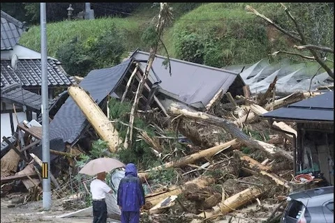
People are recommended to watch out for the risk of flashfloods and landslides in mountainous areas and inundation in low-lying ones. Heavyrains in a short period of time can cause flooding in urban areas, with apossibility of tornadoes, lightning, hail and strong winds during thunderstorms./.
VNA

See more

A green sea turtle returns to lay eggs on Cau Cang Beach. (Photo: VNA)

Rare sea turtle lays eggs on Lam Dong province's Hon Cau Beach

In recent years, to raise public awareness of marine conservation and sea turtle protection, the Hon Cau Marine Protected Area has actively engaged local residents and volunteers in beach patrols and nest ground monitoring. Thanks to these efforts, thousands of baby turtles have been successfully hatched and released back into the sea.

Emission inspections for motorcycles and motorised vehicles will begin in Hanoi and Ho Chi Minh City on July 1, 2027. (Photo: VNA)

Emission standards for motorcycles to be issued in July

Under the draft, motorcycles produced before 2008 will be subject to the lowest level of inspection standards, level 1, while those manufactured from 2008 onwards will be assessed to a higher standard. Similar rules will also apply to motorised vehicles, with level 1 for those manufactured before 2016.

At the workshop (Photo: VNA)

Vietnam consults stakeholders on climate change scenarios

The 2025 scenarios build on Vietnam’s 2020 projections, incorporating the latest findings from the Intergovernmental Panel on Climate Change’s sixth assessment report and insights from domestic and global partners. The focus is on extreme weather events, particularly in urban areas, and rising sea levels, which threaten Vietnam’s low-lying coastal regions. The goal is to guide policymaking, urban planning, and local adaptation strategies.

Jonathan Wallace Baker, UNESCO Representative in Vietnam (right), presents the UNESCO Global Geopark Certificate for Lang Son to the provincial leadership. (Photo: VNA)

Lang Son becomes Vietnam’s 4th global geopark

Lang Son Global Geopark spans over 4,842 square kilometres, roughly 58% of the province, and is home to around 627,500 people. It features a rich blend of geological wonders and cultural heritage, including stunning caves and sinkholes such as Nguom Mooc Cave, Tham Lum and Ung Roac. Its biodiversity is also protected within the Huu Lien Nature Reserve.

Visitors flock to see rare insect specimens at the Da dang sac mau con trung Vietnam (The Diversity of Vietnamese Insects) exhibition at the Da Nang Museum. (Photo: nld.vn)

Da Nang exhibition features rare insects endemic to Vietnam

To run until July 13, the Da dang sac mau con trung Viet Nam (The Diversity of Vietnamese Insects) exhibition at the Da Nang Museum features hundreds of rare insect specimens, aiming to spotlight the diversity and uniqueness of the country’s endemic insects.

The Phu Ho agricultural cooperative in Phu Ho commune, Phu Vang district, Hue city mobilises manpower and pumps to drain floodwater and save rice crops for local farmers. (Photo: VNA)

PM orders strengthened disaster preparedness ahead of storm season

Under the directive, the PM instructed relevant agencies to regularly inspect, supervise and proactively implement disaster prevention, response and rescue measures in line with their assigned roles and mandates, ensuring readiness, avoiding passivity or delays, and maintaining operational continuity amid ongoing political and administrative restructuring at levels.

The research team collects seawater samples in Ha Long Bay and Cua Luc. (Photo: VNA)

Vietnam pioneers use of AI and remote sensing to monitor seawater quality

According to Dr. Vu Anh Tuan, Deputy Director General of the Vietnam Space Centre and head of the project, this is the first study in Vietnam to simultaneously employ Sentinel-2 satellite data, advanced machine learning algorithms, and the Google Earth Engine (GEE) cloud computing platform to model and monitor key seawater quality parameters.