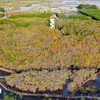
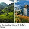
An ariel view of Kon Ka Kinh national park
 Hanoi (VNA) - Kon Ka Kinh National Park is located on the Kon Tum Plateau, in the areas of districts Mang Yang, KBang, and Dak Doa of Gia Lai Province. The center of the park is situated in the Commune of Ayun, Mang Yang district, northeast of Gia Lai Province.
With the purpose of preserving subtropical forests in the high mountains with species of gymnosperm, Kon Ka Kinh National Park was one of four national parks in Vietnam, together with three other national parks in Vietnam: Ba Be, Chu Mom Ray and Hoang Lien), also one of 27 national parks in ASEAN was listed on ASEAN Heritage Park. Kon Ka Kinh National Park is a priority zone for the protection of biodiversity of Vietnam as well as ASEAN.
Reportedly, the garden takes its name after the name of Kon Ka Kinh highest mountain, higher than 1.748m above the sea level. The mountain is also known as the “roof of Gia Lai province”. Winning the top of Kon Ka Kinh has always been the dreams of many adventurous tourists. It is most suitable to visit Kon Ka Kinh in the period from January to June (the dry season in Western Highland). Currently, Board of Management of Kon Ka King Park has initially implemented many activities to develop tourism such as: natural paths ecotourism, Winning top of Kon Ka King, holiday tourism, studying wild animals, and cultural tourism.
To the north of the national park, elevations gradually increase towards Mount Ngoc Linh, the highest point in the central Annamites. To the south and west, the topography is flatter, and altitudes are below 500 m. Altitudes within the national park range from 570 m in the Ba river valley, to 1,748 m at the summit of Mount Kon Ka Kinh.
Streams from the eastern part of the park supply water source Ba River, a twisted river running north-south until it meets the confluence A Yun River and then changes its direction to northwest-southeast before emptying into Southern Asia Sea in Tuy Hoa city; while to the west of the river lays distributaries of Mekong River. Due to the sloping topography, rivers in this park are short, running fast and creating many waterfalls.
Due to the characteristics of its topography, climate, soil conditions, and other factors, this park contains a great deal of biodiversity. According to the survey results, Kon Ka Kinh National Park contained 687 flora species of 459 genus and 140 families, of which the class of Magnoliopsida is dominant (104 families, 337 genus, 528 species).
Kon Ka Kinh National Park has 33,565 natural forest, accounting for 80% of its total area. It is home to mountainous biological typical lives. There are about 20 square kilometres of broadleaf and needle leaf trees, primarily Pomu (Fokienia hodginsii).
It is home to 428 animal species, of which, 223 species of vertebrates living on land (34 ordos, 74 families) and 205 species Invertebrates (such as butterfly) of 10 families of (Lepidoptera).
The National Park is also a globally important site for the conservation of amphibian diversity. Kon Ka Kinh supports a number of amphibian species endemic to the Annamite mountains, including four species assessed as globally threatened during the Global Amphibian Assessment: Leptobrachium banae, L.xanthospilum, Rana attigua and Rhacophorus baliogaster.
The park is of importance to local people as a source of natural resources, such as firewood honey and rattans. Also, the national park supports at least 110 plant species with known medicinal uses. Use of plants in traditional medicine is widespread amongst local people, although the commercial potential of these species remains largely unrealized.
Kon Ka Kinh National Park offers people with a lot of amazing activities from natural paths ecotourism, cultural tourism, studying wild animals tourism to holiday tourism.
From Pleiku, jump into a car to get to Kon Ka Kinh National Park. After visiting the park for a while, you can go to visit the House of Specimen animals and plants so as to learn about the biodiversity values. Next, go to visit the beauty of wild orchid collection.
In the evening, you can learn about “The Space of Gong Culture” and taste some delicious dishes such as grilled meat and Can wine, bamboo cooked rice whilst sitting around the bond-fire.
Ha Dung village is also a recommended place for every tourist. It has a total of 6 streams with a wide range of old trees and wild animals like wild boars, grey-feet chimpanzees, porcupines, deer and so on.
The best time to conquer the top of Kon Ka Kinh National Park is between December and March, which is the dry season in the Western Highland. During this season, the weather is cool and there are lots of flowers blossoming. And local people hold numerous festivals including elephant race festival or buffalo fighting festival./.