Various documents relating to Vietnam’s sovereignty over Hoang Sa(Paracel) archipelago will be displayed in an exhibition at the Da NangMuseum in the central city of Da Nang from April 30 to May 15.
Thedocuments aim to confirm Vietnam’s sovereignty over Hoang Sa andTruong Sa archipelagos, said the Quan doi Nhan dan (People’s Army)newspaper.
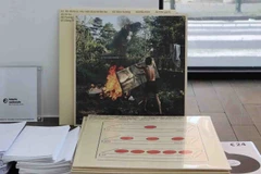
They include 95 maps published in England, Germany,Australia, Canada, the US and Hong Kong (China) in the 1626-1980 periodand 102 books printed in English, German, French, Spanish, Italian andDutch languages in the 18th and 19th centuries.
Those maps were presented to the Hoang Sa district People’s Committee by Tran Thang, an overseas Vietnamese in the US .
In addition, maps indicating that China’s southernmost territoryis Hainan Island while Hoang Sa, Truong Sa archipelagos are inVietnam ’s territorial waters will be on display.
Also atthe event, entitled “Hoang Sa belongs to Vietnam - historicalevidence”, three atlases, published by China in 1908, 1919 and 1933,will be exhibited to show that Hoang Sa and Truong Sa did nothistorically belong to China .
All the historicaldocuments and maps exhibited will be translated in English, and a groupof interpreters will be available to help foreigners learn more aboutthe exhibits.-VNA
Thedocuments aim to confirm Vietnam’s sovereignty over Hoang Sa andTruong Sa archipelagos, said the Quan doi Nhan dan (People’s Army)newspaper.
They include 95 maps published in England, Germany,Australia, Canada, the US and Hong Kong (China) in the 1626-1980 periodand 102 books printed in English, German, French, Spanish, Italian andDutch languages in the 18th and 19th centuries.
Those maps were presented to the Hoang Sa district People’s Committee by Tran Thang, an overseas Vietnamese in the US .
In addition, maps indicating that China’s southernmost territoryis Hainan Island while Hoang Sa, Truong Sa archipelagos are inVietnam ’s territorial waters will be on display.
Also atthe event, entitled “Hoang Sa belongs to Vietnam - historicalevidence”, three atlases, published by China in 1908, 1919 and 1933,will be exhibited to show that Hoang Sa and Truong Sa did nothistorically belong to China .
All the historicaldocuments and maps exhibited will be translated in English, and a groupof interpreters will be available to help foreigners learn more aboutthe exhibits.-VNA