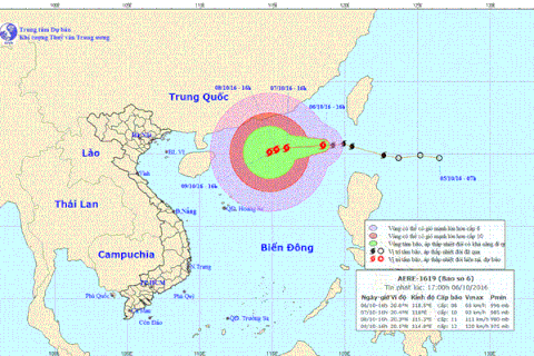
The forecast path of typhoon Aere (Photo: National Centre of Hydro-Meteorological Forecasting)
 Hanoi (VNA) – Extremely rough seas are predicted for the north of the East Sea’s northern area as typhoon Aere can continue developing in the next few hours, said the National Centre of Hydro-Meteorological Forecasting.
At 1pm of October 7, the centre of the storm, the sixth to hit the East Sea this year, was at about 20.7 degrees north latitude and 116.1 degrees east longitude, about 600km northeast of Vietnam’s Hoang Sa (Paracel) archipelago. Strongest winds in the eyewall were at 75-90km per hour.
In the next 24 hours, it is likely to move slowly north-northwest at a speed of some 5km per hour and continue to intensify.
At 1pm of October 8, its centre will be at about 21.1 degrees north latitude and 115.8 degrees east longitude, about 640km northeast of Hoang Sa. It may sustain winds of up to 105-120km per hour.
In the following 24-48 hours, the typhoon will keep moving northwest at a slow pace, about 5km per hour.
It is forecast to have its eye at 21.5 degrees north latitude and 115.3 degrees east longitude at 1pm of October 9, about 650km northeast of Hoang Sa. Wind speeds can reach up to 90-100km per hour.
Aere can shift its direction to west-southwest while moving at 5km per hour in 48-72 hours later, according to the forecasting centre.-VNA