National Geographic Society to denote “Hoang Sa” on maps
The National Geographic Society (NGS) of the US will revise the naming
conventions of the Hoang Sa (Paracel) archipelago in its maps, according
to the
society’s latest statement issued on March 25.
The National Geographic Society (NGS) of the US will revise the naming
conventions of the Hoang Sa (Paracel) archipelago in its maps, according to the
society’s latest statement issued on March 25.
The NGS says on larger-scale regional, continental and sectional maps, the NGS will use the conventional name – Paracel Islands with possession qualifier -- “occupied by China in 1974, which calls them Xisha Qundao; claimed by Vietnam , which calls them Hoang Sa”.
For smaller-scale world maps, the NGS will use the conventional name of Paracel Islands and omit possession label, the statement said, adding that the new naming conventions had been adopted following the NGS’s Map Policy Committee’s recent discussions on the matter.
The committee said based on the best information and research available, it wants to make “independent judgments about future changes or clarifications on its maps, as well as to correct any errors.”
The NGS affirmed that these conventions will apply on future printings of its maps and will be reflected online in short order.
However, a world map posted on the site still denotes “Paracel Is” with the word “ China ” in red letters below.
Recently, the NGS has posted the online world map on which it designates the Chinese name of “Xisha Qundao” with the word “ China ” in the Hoang Sa (Paracel) archipelago of Vietnam at http://www.natgeomaps.com , prompting waves of both official and public protest.
On March 13, Vietnamese foreign ministry’s spokesperson Nguyen Phuong Nga claimed that “the world map denoting ‘Paracel Is. China ’ published by the National Geographic is wrong” and requested that the society correct this mistake.
The Vietnamese spokeswoman again reiterated that “ Vietnam has indisputable sovereignty over the Hoang Sa and Truong Sa archipelagoes.”
On March 16, the NGS admitted in a press release that denoting the Hoang Sa archipelago with the Chinese name and the word “ China ” without further explanation can be misleading or misinterpreted./.


You should also see

China’s fishing ban in East Sea violates Vietnam’s sovereignty: spokesperson
Foreign Ministry spokesperson Pham Thu Hang on April 25 said Vietnam’s consistent stance on China’s fishing ban in the East Sea, which has been affirmed clearly over the past years.


See more
 Politics
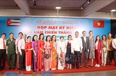
Anniversary of Cuba’s Giron Victory marked in HCM City
The Ho Chi Minh City Union of Friendship Organisations (HUFO) and the city's Vietnam - Cuba Friendship Association (VCFA) held a gathering on April 25 to celebrate the 63rd anniversary of Cuba’s Giron Victory (April 19, 1961 - 2024).
 Politics
Vietnam vows to achieve Sustainable Development Goals: Diplomat
Vietnamese Ambassador-designate to Thailand and head of the Vietnamese delegation to the Economic and Social Commission for Asia and the Pacific (ESCAP) Pham Viet Hung highlighted Vietnam's commitment to achieving the 2030 Agenda for Sustainable Development and Sustainable Development Goals (SDGs) while delivering a speech at the ESCAP’s 80th annual session in Bangkok, Thailand, on April 25.
 Videos
Geneva Accords: A guide to Vietnamese diplomacy
Along with the Dien Bien Phu Victory, the negotiation and signing of the Geneva Accords on July 21, 1954 not only marked a historic milestone for Vietnam but also held profound significance for the world. The negotiation, signing, and implementation of the Accords served as a valuable handbook on the Vietnamese school of foreign affairs and represented a major victory for its military and people.
 Politics
Vietnam reiterates commitment to human rights: Spokeswoman
Vietnam once again affirms its consistent policy of protecting and promoting human rights, considering human beings a centre and driving force of the country's renewal and development process, Spokeswoman of the Ministry of Foreign Affairs Pham Thu Hang said at the ministry's regular press conference in Hanoi on April 25.
 Politics
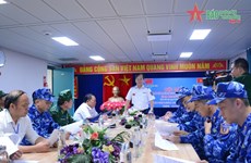
Vietnam, China conducts joint patrol along demarcation line in Gulf of Tonkin
Two vessels of the Vietnam Coast Guard (VCG) on April 25 departed from the northern port city of Hai Phong for a joint patrol mission with the China Coast Guard (CCG) in the vicinity of the countries’ demarcation line in the Gulf of Tonkin.