Over 10,200 areas in Vietnam face landslide threats

Vietnam has more than 10,200 sites prone to landslide risks located in ten northern mountainous localities, according to the Vietnam Institute of Geosciences and Mineral Resources under Ministry of Natural Resources and Environment.
Over 10,200 areas in Vietnam face landslide threats ảnh 1
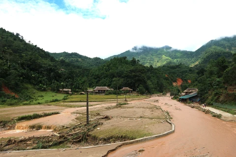
Traffic is blocked after a landslide in Sa Pa district, the northern mountainous province of Lao Cai last month (Photo: VNA)

Hanoi (VNS/VNA) - Vietnam hasmore than 10,200 sites prone to landslide risks located in ten northernmountainous localities, according to the Vietnam Institute of Geosciences andMineral Resources under Ministry of Natural Resources and Environment.

Trinh Xuan Hoa, deputy head of the institute told Vietnam News Agency thatlandslides and flash floods that cause serious consequences of human losses andproperty damage frequently occur in the recent years in provinces of Lao Cai, SonLa, Yen Bai, Hoa Binh, Lai Chau and Thanh Hoa.

Abnormal weather conditions such as prolonged torrential rain and humanactivities including deforestation, mineral exploitation, construction are themain causes of landslides, threatening community safety.

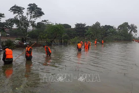
Flash floods and landslides in June last year in northern mountainouslocalities swept away 176 houses, damaged 1,270 others and destroyed more than1,000ha of rice fields. As many as 33 people died and went missing. The totaldamage was estimated at some 535 billion VND (22.8 million USD).

During the 2000-15 period, there were 250 flash floods and landslidesnationwide with 779 people being killed or going missing, 426 others injured.Economic losses were up to dozens of trillions of dong, according to NaturalCalamity Prevention and Control General Department.

Dr Nguyen Duc Manh from the University of Transport and Communications saidthat Vietnam has had a number of geological studies on landslide risks andmapped landslide areas, however, a lot of managers lack attention tolandslides.

“When each rainy season comes, many areas are put on the red alert oflandslides like Xin Man town of Ha Giang province. Although the disaster riskshave been pointed out by researchers and the Government has ordered naturaldisaster prevention, reduction and responding plans, localities remain passivein addressing the problem due to lacking budget,” he said.

“We are fixing landslides at single points where buildings or trafficinfrastructure are located. Most of landslides are fixed only when they happenbut we have not thought about sustainable solutions for the whole residentialareas,” he said.

Deputy head of the Vietnam Institute of Geosciences and Mineral Resources TrinhXuan Hoa said that landslides can be prevented by planting more trees inprotective forests, recovering natural forests, stopping planting trees forexploitations purposes and not building residential areas near landsliderisk-prone sites.

Local people should be aware of how to respond to and reduce damages caused bylandslides during rainy season. Alert devices must be installed at areas proneto high risks of flash floods and landslides, he said.

According to Hoa, there are several solutions to relocate residents from areasprone to landslides. One of them is to move risk-prone people to live in safecommunity. This solution does not need much infrastructure investment butrequires local authorities to offer assistance to people newly moving in.

Another solution is to map safe zones and move all risk-prone residents toresettlement areas. But this solution needs local land space.

In case there are no land funds, local authorities should build dams,embankments and plant protective forests to reduce natural calamity damage.

The Institute of Geosciences and Mineral Resources has completed landslide mapfor 18 out of 37 northern mountainous areas and is doing more research toupdate communes’ landslide details which serve as a reference for localities torelocate residents out of risky areas.-VNS/VNA
VNA

See more

Induced seismicity has been continually observed in Kong Plong district since 2021. (Photo: VNA)

4.2 magnitude quake strikes Kon Tum province

A 4.2-magnitude earthquake jolted Kong Plong district in the Central Highlands province of Kon Tum on early January 9 morning, according to the Vietnam Earthquake Information and Tsunami Warning Centre under the Institute of Geophysics.

The over 220 kg bomb is carried to a secure storage area in the central province of Quang Binh for safe detonation. (Photo: VNA)

Over-220kg bomb with intact fuse safely handled in Quang Binh

The Mines Advisory Group (MAG) in Vietnam confirmed on January 4 that its experts and mobile bomb disposal team have safely handled and moved a bomb weighing over 220 kg to a secure storage area in the central province of Quang Binh, where it will await safe detonation.

Workers collect waste for recycling in Hanoi (Photo: VNA)

Classifying solid waste at source mandatory from January

Domestic solid waste must be classified at each household from the beginning of this year, according to the Law on Environmental Protection 2020, which is considered a breakthrough step towards turning waste into resources.

One Javan pangolin released back to nature (Photo: VNA)

Twelve Javan pangolins released back to nature

The Cuc Phuong National Park in the northern province of Ninh Binh, in collaboration with the Save Vietnam's Wildlife (SVW), successfully released 12 Javan pangolins (Manis Javanica) back into the wild on January 2.

The “Let’s Green Unitour” programme is launched to expand the green university model nationwide. (Photo: gogreen.ueh.edu.vn)

Go Green University network promoted nationwide

The University of Economics Ho Chi Minh City (UEH) and the Vingroup Future Green Fund launched the “Let’s Green Unitour” programme to expand the green university model to 10 higher education institutions nationwide.

The Planning, Fair and Exhibition Palace is devastated by Typhoon Yagi on September in the north-eastern province of Quang Ninh. (Photo: VNA)

Centre to apply AI to tropical cyclone forecasting

The Hanoi University of Science and Technology's Institute for Research and Application of Artificial Intelligence, alongside relevant units, has been told to work closely with the National Centre for Hydro-Meteorological Forecasting (NCHMF) to integrate artificial intelligence (AI) into the forecasting of tropical cyclones ahead of the 2025 rainy and storm season.

High-rise buildings on Nguyen Chi Thanh street in Hanoi are under a layer of fog (Photo: VNA)

Hanoi targets 80% of days with good or moderate air quality annually

Hanoi has set a target to ensure that up to 80% of the days in a year have air quality index (VN-AQI) levels rated as good or moderate, based on data from standard national and city monitoring stations, according to the director of the city’s Department of Natural Resources and Environment, Le Thanh Nam.

At Tram Chim National Park in the Mekong Delta province of Dong Thap (Photo: VNA)

Dong Thap revives red-crowned crane population

In a bid to save its iconic symbol, the Mekong Delta province of Dong Thap is embarking on a conservation and development scheme for the critically endangered red-crowned cranes at the Tram Chim National Park for the 2022–2032 period.

The workshop on developing indigenous resources and local economies through regional linkages is held as part of the Mekong Connect Forum 2024. (Photo: VNA)

Nature-based projects help Mekong Delta fight climate change

Nature-based projects implemented by the World Wildlife Fund (WWF) Vietnam in the Mekong Delta region have helped support local residents to adapt to climate change, heard at a workshop which is part of The Mekong Connect Forum 2024 held in Mekong Delta province of An Giang on December 17.