Typhoon Noru enters the East Sea in the small hours of September 26 (Photo: VNA)
 They must keep a close watch on the developments of the storm and promptly implement directions from central agencies, while guiding vessels to seek safe shelter and supporting farmers to protect their aquatic farms.
Along with ensuring safety for reservoirs and dams, it is crucial to evacuate people in areas with high risks of landslides, the PM stressed.
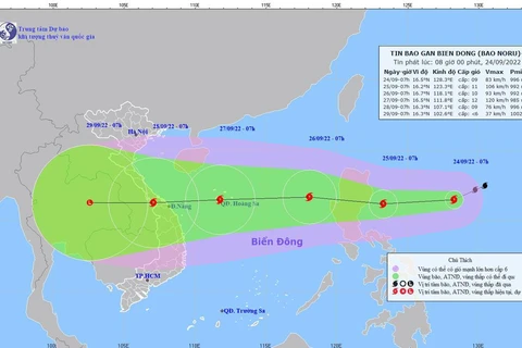
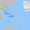
According to the National Centre for Hydro-Meteorology Forecasting, Typhoon Noru entered the East Sea in the small hours of September 26, becoming the fourth hitting the area, boasting winds of up to 149km per hour.
As of 4am on September 26, the storm centred at the west of Luzon island in the Philippines, about 810km from Vietnam’s Hoang Sa (Paracel) archipelago.
In the next 24 hours, it is forecast to move west-northwest towards the East Sea with a speed of 20-25km per hour. As of 4am on September 27, its eye is predicted to be 410 kilometers east of Hoang Sa, with win velocity of 134-149km per hour.
In the following 24-48 hours, the storm will continue to move west at a speed of 20-25km per hour and gain more strength. As of early morning on September 28, the eye of the storm is likely to be around 170km east of Da Nang-Binh Dinh mainland, with strongest winds of 166km per hour.
In the following 48-72 hours, Storm Noru will make a landfall in the central region before weakening into a low pressure, which is forecast to move westwards.
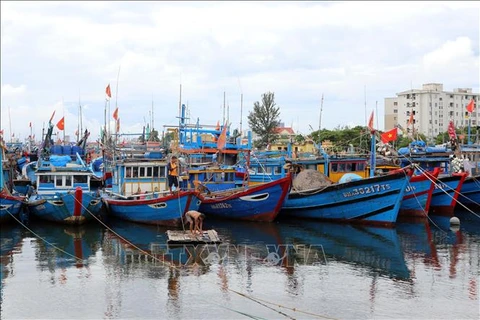
 Localities from Nghe An to Binh Dinh have guide 57,800 vessels to seek safe shelters (Photo: VNA) Due to impacts of the storm, from September 26, waters in the south of the northern part of the East Sea will be extremely rough with 8-10m waves. Torrential rains of 150-300mm are forecast in central area of the the central region and the north of Central Highlands region within September 27-28. National disaster risks at Levels 3-4 have been alerted in regional localities.
In response to the storm, the Ministry of Health has sent a dispatch to coastal cities and provinces from Quang Ninh to Binh Thuan and its agencies in northern and central regions, asking them to apply measures to stand ready to provide healthcare services to victims of torrential rains and flooding and prevent the interruption of treatment activities.
They were asked to maintain measures to prevent and control COVID-19 as well as dengue fever at the same time.
On September 25, Deputy Prime Minister Le Van Thanh chaired a meeting to discuss measures to respond to the storm, during which he asked the National Steering Committee for Natural Disaster Prevention and Control, the National Committee for Natural Disaster Response and Search and Rescue as well as ministries and sectors to intermediately establish working groups to direct storm responding activities in affected localities.
Vietnam Meteorological and Hydrological Administration General Director Tran Hong Thai said that Da Nang city and Quang Nam, Quang Ngai and Binh Dinh provinces are likely to be hardest hit by the storm, with natural disaster risk at Level 4.
Meanwhile, Pham Duc Luan, deputy head of the Standing Board of the National Steering Committee for Natural Disaster Prevention and Control, said that localities from Nghe An to Binh Dinh have guide 57,800 vessels to seek safe shelters, and called back 739 vessels operating at sea.
Localities from Quang Binh to Binh Thuan have built plans to evacuate 214,000 households with more than 868,000 people to safer places./.
As of 4am on September 26, the storm centred at the west of Luzon island in the Philippines, about 810km from Vietnam’s Hoang Sa (Paracel) archipelago.
In the next 24 hours, it is forecast to move west-northwest towards the East Sea with a speed of 20-25km per hour. As of 4am on September 27, its eye is predicted to be 410 kilometers east of Hoang Sa, with win velocity of 134-149km per hour.
In the following 24-48 hours, the storm will continue to move west at a speed of 20-25km per hour and gain more strength. As of early morning on September 28, the eye of the storm is likely to be around 170km east of Da Nang-Binh Dinh mainland, with strongest winds of 166km per hour.
In the following 48-72 hours, Storm Noru will make a landfall in the central region before weakening into a low pressure, which is forecast to move westwards.
 Localities from Nghe An to Binh Dinh have guide 57,800 vessels to seek safe shelters (Photo: VNA)
 In response to the storm, the Ministry of Health has sent a dispatch to coastal cities and provinces from Quang Ninh to Binh Thuan and its agencies in northern and central regions, asking them to apply measures to stand ready to provide healthcare services to victims of torrential rains and flooding and prevent the interruption of treatment activities.
They were asked to maintain measures to prevent and control COVID-19 as well as dengue fever at the same time.
On September 25, Deputy Prime Minister Le Van Thanh chaired a meeting to discuss measures to respond to the storm, during which he asked the National Steering Committee for Natural Disaster Prevention and Control, the National Committee for Natural Disaster Response and Search and Rescue as well as ministries and sectors to intermediately establish working groups to direct storm responding activities in affected localities.
Vietnam Meteorological and Hydrological Administration General Director Tran Hong Thai said that Da Nang city and Quang Nam, Quang Ngai and Binh Dinh provinces are likely to be hardest hit by the storm, with natural disaster risk at Level 4.
Meanwhile, Pham Duc Luan, deputy head of the Standing Board of the National Steering Committee for Natural Disaster Prevention and Control, said that localities from Nghe An to Binh Dinh have guide 57,800 vessels to seek safe shelters, and called back 739 vessels operating at sea.
Localities from Quang Binh to Binh Thuan have built plans to evacuate 214,000 households with more than 868,000 people to safer places./.
VNA