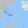
Maps demonstrating areas vulnerable to elevated water levels caused by hurricanes in coastal provinces are at the heart of a project to cope with super typhoons conducted by the National Steering Committee for Flood Control and Prevention.
The project comes on the heels of the historic storm Haiyan, the strongest cyclone ever recorded on land that claimed at least 7,350 lives as it devastated large parts of the central Philippines . The maps create a scientific base for local and central agencies to stay proactive in designing plans to addressing super typhoon responses in the future.
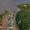
The National Hydro-Meteorology Forecasting Centre calculated the effects a future super typhoon, like that of Haiyan, could have for the northern port city of Hai Phong .
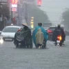
The results showed the highest water level in the city could exceed 5.3 meters, above most of the current sea dykes and submerging many of the inner districts. Many areas could be flooded under one or two metres of water.
The inadequate dyke system poses a serious risk in the future as the sea level rises in response to climate change.
Scientists encouraged expanding in-depth research studies in the field to effectively serve current and future typhoon response initiatives, including evaluating the exact submergence possibility caused by super typhoons.
Evaluations by the Ministry of Natural Resources and Environment indicate that storms occurring in the north of the East Sea are likely to reduce in frequency but rise in intensity, causing serious human and structural losses.
According to the World Meteorological Organisation, the categorisation of super storms involve those with wind speeds over 51 metres per second or 184 kilometres per hour, and a low barometric pressure in the eye of the storm of 927 millibars.-VNA
The project comes on the heels of the historic storm Haiyan, the strongest cyclone ever recorded on land that claimed at least 7,350 lives as it devastated large parts of the central Philippines . The maps create a scientific base for local and central agencies to stay proactive in designing plans to addressing super typhoon responses in the future.
The National Hydro-Meteorology Forecasting Centre calculated the effects a future super typhoon, like that of Haiyan, could have for the northern port city of Hai Phong .
The results showed the highest water level in the city could exceed 5.3 meters, above most of the current sea dykes and submerging many of the inner districts. Many areas could be flooded under one or two metres of water.
The inadequate dyke system poses a serious risk in the future as the sea level rises in response to climate change.
Scientists encouraged expanding in-depth research studies in the field to effectively serve current and future typhoon response initiatives, including evaluating the exact submergence possibility caused by super typhoons.
Evaluations by the Ministry of Natural Resources and Environment indicate that storms occurring in the north of the East Sea are likely to reduce in frequency but rise in intensity, causing serious human and structural losses.
According to the World Meteorological Organisation, the categorisation of super storms involve those with wind speeds over 51 metres per second or 184 kilometres per hour, and a low barometric pressure in the eye of the storm of 927 millibars.-VNA