National park in Kien Giang builds digital map for fighting forest fires

The U Minh Thuong National Park in the Mekong Delta’s Kien Giang province has built a digital map on areas at high risk of forest fires in an attempt to prevent and tackle such disasters during the 2020-2021 dry season, Deputy Director of the park Tran Van Thang has said.
National park in Kien Giang builds digital map for fighting forest fires ảnh 1
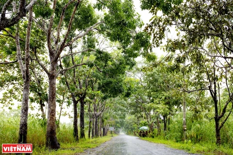
A corner of the U Minh Thuong National Park (Photo: VNA)
Kien Giang (VNA) - The U Minh Thuong National Park in theMekong Delta’s Kien Giang province has built a digital map on areas at high riskof forest fires in an attempt to prevent and tackle such disasters during the2020-2021 dry season, Deputy Director of the park Tran Van Thang has said.

The park has also devised measures to fight forest fires and deploypersonnel along with vehicles in wildfire suppression efforts, so as tominimise losses as concerns rise about widespread and prolonged heat anddrought.

It has taken the initiative in water storage for firefighting and the developmentof cajuput forests, as well as strengthened six sluices and built two dykes.Seven reservoirs have been dredged and consolidated.

Four teams with up to 10 members each have been assigned to keep watch aroundthe clock in areas spanning 1,115 ha at high risk of forest fires, while communicationson forest protection and forest fire prevention have been bolstered.

Straddling Kien Giang’s An Minh Bac and Minh Thuan districts, the UMinh Thuong National Park covers a natural area of more than 8,537 ha,including 8,038 ha set for special-use forests.

As of the end of 2020, its forest area neared 6,485 ha./.
VNA

See more

Each location is equipped with three bins for residents to sort waste at source. (Photo: baotayninh.vn)

Tay Ninh partners with RoK to pilot waste-sorting at source

The project, with KECO serving as a technical consultant, aims to strengthen integrated waste management, develop effective systems for classification, collection and recycling, and enhance public awareness of turning waste into resources, thus contributing to a cleaner and more sustainable Tay Ninh.

A camera trap photo of a Chinese serow (Capricornis milneedwardsii) in the Dong Chau – Khe Nuoc Trong Nature Reserve (Photo published by VNA)

Quang Tri province approves wildlife restoration project

The project has a total non-refundable grant value of 48,310 USD and will be implemented in Kim Ngan commune until December 31, 2027. This initiative aims to restore wildlife populations, enhance biodiversity, and reduce illegal hunting through patrolling and the removal of snares.

Houses in Xuan Canh commune, Dak Lak province, completely collapse. (Photo: VNA)

Typhoon Kalmaegi damages over 26,470 houses and causes extensive losses

The typhoon and its aftermath left five people dead, three missing, and 17 injured. It also damaged 3,721 ha of rice and crops, and 3,958 ha of industrial and perennial fruit trees, up by 14 ha from the previous report. For aquaculture, 54,335 cages and 18 ha of shrimp and fish farms were destroyed, along with 118 cattle and 3,593 poultry. Additionally, 21 boats were sunk and 44 others damaged.

Nguyen Thi Vang is the oldest member of the scrap-collecting cooperative group in An Dong ward in Hue city. (Photo: VNA)

Hue turns waste into resource through tech-enabled scrap collectors

Through the mGreen application, women who once earned their living by collecting recyclable waste have become “green warriors” connected to a digital recycling supply chain. The initiative is not only improving livelihoods and enhancing social status but also forming a sustainable waste circulation loop, reinforcing Hue’s image as a green city.

Vice Chairman of the Hanoi People’s Committee Nguyen Manh Quyen receives Sylvain Ouillon, Chief Representative of the French National Research Institute for Sustainable Development (IRD) in Vietnam (Photo: Hanoi Moi)

Hanoi strengthens ties with IRD to tackle air pollution

Vice Chairman of the Hanoi People’s Committee Nguyen Manh Quyen on November 6 received Sylvain Ouillon, Chief Representative of the French National Research Institute for Sustainable Development (IRD) in Vietnam, to discuss potential cooperation in air quality monitoring and pollution reduction in the capital city.

Houses inundated by storm-triggered flooding. (Photo: VNA)

Central, Central Highlands localities race to recover from Storm Kalmaegi

According to Vietnam Disaster and Dyke Management Authority (VDDMA), the storm left five people dead and six injured. As of 7 a.m. on November 7, 52 houses had collapsed and 2,593 others were damaged or unroofed, including 2,412 in Gia Lai province. Nine fishing vessels were reported sunk.

High waves in Ly Son island, Quang Ngai province due to Typhoon Kalmaegi. (Photo: VNA)

Central, Central Highlands localities respond to Typhoon Kalmaegi

As Typhoon Kalmaegi, the 13th storm to hit the East Sea this year, intensifies and heads toward Vietnam’s central coast, localities across the central and Central Highlands regions, including Dak Lak, Lam Dong, Da Nang and Quang Ngai, have activated their highest-level disaster response measures to ensure the safety of people and property.