A helicopter with rescuers is performing rescue activities for crewmembers of Vietship 01 (Photo: VNA)
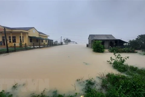
 Quang Tri (VNA) – Rising flood level in Ben Hai, Hieu, Thach Han and O Lau rivers in the central province of Quang Tri killed one locals and affected 39,700 households as of October 11 morning, reported the provincial Steering Committee for National Disaster Prevention and Control.
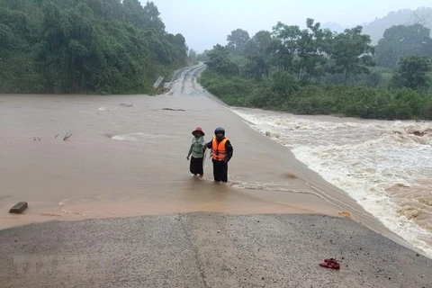
The province has moved more than 6,900 households with over 20,300 people from flooding areas with high risk of landslides to safer places. The locality is also mobilising forces to search for six people missing, five in the mainland and one at sea.
So far, floodwater has swept away 790 hectares of aquatic farms, more than 1,230 hectares of crop areas, and 138,600 poultry, while damaging various roads.
On October 11 morning, rescuers have continued to salvage nine people trapped in Vietship 01 vessels which has been stranded in waters at about 400m from Cua Viet port.
Quang Tri suffered from widespread torrential rains from October 6-10 with highest rainfall of over 1,340mm in some places.
Meanwhile in central Quang Binh province, floods also left one died and one missing, while drowning more than 14,700 houses and isolating many villages. Local authorities are working hard to supply foods to people in isolated areas and evacuate locals in risky areas to safe shelters.
In Tan Hoa commune of Minh Hoa district, about 600 houses have been deeply submerged in floodwaters, along with schools and the headquarters of the communal People’s Committee.
In Tan Ninh commune of Quang Ninh district, floodwater with 0.5-3m in depth also isolated many villages. Locals have received 200 packages of foods and clean water.
Flood levels in Nhat Le and Kien Giang rivers is reducing but still at alert level three.
Initial report showed that about 877 hectares of aquatic farms, 314 hectares of trees, 1,146 hectares of crop, and 12 hectares of rice farms have been damaged.
At the same time, the central city of Da Nang is exerting efforts to search for three people missing due to heavy rains and flooding, including two at sea.
The natural disasters have sunken three boats and made one stranded. As of October 11 morning, eight boats with 79 crewmembers remained operations at sea. Safety alert has been sent to the boats.
Earlier, the city evacuated 754 households with 2,567 people to safer places./.
VNA