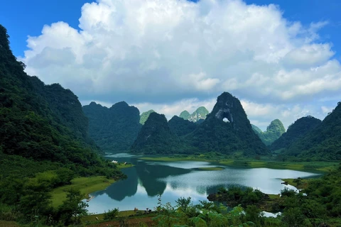
A view of Nui Thung (Thung Mountain) in Tra Linh district of Cao Bang province (Photo: VNA)
 Hanoi (VNA) – Cao Bang, a famous tourist province in the northeastern region of Vietnam, boasts many untouched beautiful landscapes that are waiting to be explored.
Ban Sam Waterfall
Ban Sam Waterfall is located in Thuan Hoa township, Quang Hoa district, about 3km from National Highway 3 and 56km from Cao Bang city. The waterfall is part of the Non Nuoc Cao Bang UNESCO Global Geopark.
Ban Sam Waterfall is on Sam Xuyen stream, a small branch that blends into the Bang River. It is most beautiful from April to July every year. With spectacular, pristine landscapes and rich ecosystems, along with fresh and cool air, the waterfall is becoming a new destination for those who love to explore nature.
It is an ideal destination for any who wishes to find a place to relax, listen to the sounds of natures and enjoy delicious dishes with a strong mountain flavour.
Thong Loc Waterfall
Thong Loc Waterfall, located in Hong Loc hamlet, Doai Duong commune of Trung Khanh district, is a wonderful combination of alpine air and water, as it juts through the rocky landscape.
The best time to visit the waterfall is spring when its flow increases and wakes up after a long winter. Located at the source of the Bac Vong River, quietly and powerfully flowing from high cliffs, Thong Loc Waterfall boasts peaceful and poetic beauty.
Thong Loc Waterfall is a gift from nature to Doai Duong commune and Trung Khanh district. It is highly recommended for tourists to admire the beauty of the waterfall and enjoy the fresh air of a peaceful countryside on the borderlands of Vietnam.
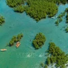
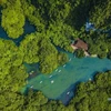
Thung Mountain
Located in the middle of a beautiful valley in the border district of Tra Linh, Angel Eye Mountain, locally known as Nui Thung, is a favourite destination for young people’s camping activities of in Cao Bang province.
Nui Thung impresses visitors with its unique appearance as it has a great hole-shaped crevasse, measuring 50m in diameter, passing through its face, which looks like a giant eye at the centre of the mountain.
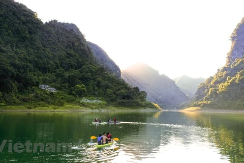
At the foot of the mountain, campers can find a perfect place to set up their camps on immense grasslands or by green lakes. They can admire the charming natural landscapes while walking around and taking photos.
When night falls, the temperature can drop as low as in winter. Even though a campfire may be built, campers should prepare warm clothes in advance.
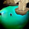
Upon rising, an interesting activity at the beginning of the day is paddling a stand-up paddle-board (SUP) on the lake and listening to the birds singing while fog still lingers in the air.
After that, backpackers can join a trek to take a closer look at the "eye" of the mountain, which is a cave crisscrossed with clusters of tree roots. In their trek, backpackers can encounter Tay ethnic people with their traditionally friendly and warm smiles to greet visitors.
Canh Cao sinkhole area and pristine Little Son Doong
The system of limestone mountains in the Non Nuoc Cao Bang Geopark has many unique features with caves described as "Little Son Doong".
The Canh Cao sinkhole area is located in the middle of Lung Ga Plateau in Ngu Lao commune, Hoa An district. From the headquarters of the Ngu Lao communal People's Committee, it takes visitors 5km walking on zigzag roads to Lung Ga Plateau. After that, they have to walk about 2km of the trail to the Canh Cao sinkhole area.
The space under the Canh Cao sinkhole with nearly 100m high wall and a basin of several thousand square meters creates a feeling that make visitors feel like they are standing in a miniature version of the world famous Son Doong Cave in Quang Binh province.
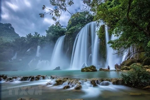
Quay Son River
The Quay Son River starts from China and when it reaches Dam Thuy commune of Trung Khanh district, the mild river circles around Co Muong Mountain bottom and flows to the rice fields of Dam Thuy towards the large alluvial plain of Ban Gioc village.
Looming in the background of rice fields are villages of Tay ethnic people with ancient stone houses on stilts, creating a nostalgic beauty.
The river forms the border between Vietnam and China. The flow divides into many branches that create Ban Gioc Waterfall, a top tourist destination in Cao Bang province.
The 53m high and 300m wide waterfall is the fourth largest border waterfall in the world and was named one of the 10 most spectacular waterfalls in the world by travel site Touropia./.