Severe flooding inundates Hue city as rivers overflow alarm level 3

Early on November 3, a landslide occurred on National Highway 49 at Kim Quy Pass between Binh Dien and A Luoi communes, disrupting traffic on the key route linking Hue city with its western mountainous districts.

Water levels on the Huong River in Hue city continue to rise as recovery efforts from the previous flood are still under way on the afternoon of November 2. (Photo: VNA)

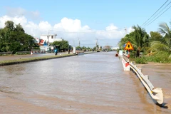
Hue (VNA) – The water levels of the Huong and Bo rivers in Hue city surpassed alarm level 3 as of 7 am on November 3, according to the city’s hydro-meteorological station.

At Kim Long, the Huong river at Kim Long reached 3.75 m, 0.25 m above level 3, while the Bo river at Phu Oc measured 4.7 m, exceeding level 3 by 0.2 m.

Heavy to very heavy rainfall is forecast to continue over the next few hours, with total precipitation ranging from 20 to 40 mm and some areas likely receiving more than 70 mm.

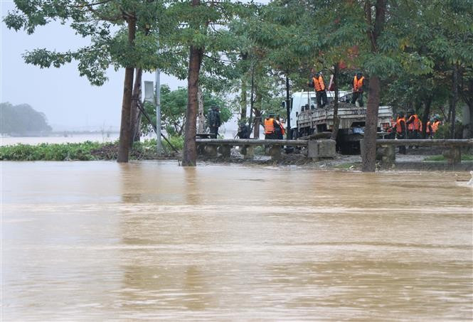
The prolonged downpour has caused rapid rises in river levels, leading to extensive flooding across downstream areas, low-lying zones, and urban centres. Flash floods and landslides have also been reported in mountainous regions, threatening construction sites, transport infrastructure, aquaculture, and agriculture, and affecting social, economic, and environmental activities.

Early on November 3, a landslide occurred on National Highway 49 at Kim Quy Pass between Binh Dien and A Luoi communes, disrupting traffic on the key route linking Hue city with its western mountainous districts.

Local authorities have mobilised forces and equipment to clear debris and restore traffic, with the road expected to reopen later the same morning. Smaller landslides along the route had previously been promptly handled.

The flooding comes as Hue city continues to recover from two major flood events that struck late last month./.

VNA

See more

A camera trap photo of a Chinese serow (Capricornis milneedwardsii) in the Dong Chau – Khe Nuoc Trong Nature Reserve (Photo published by VNA)

Quang Tri province approves wildlife restoration project

The project has a total non-refundable grant value of 48,310 USD and will be implemented in Kim Ngan commune until December 31, 2027. This initiative aims to restore wildlife populations, enhance biodiversity, and reduce illegal hunting through patrolling and the removal of snares.

Houses in Xuan Canh commune, Dak Lak province, completely collapse. (Photo: VNA)

Typhoon Kalmaegi damages over 26,470 houses and causes extensive losses

The typhoon and its aftermath left five people dead, three missing, and 17 injured. It also damaged 3,721 ha of rice and crops, and 3,958 ha of industrial and perennial fruit trees, up by 14 ha from the previous report. For aquaculture, 54,335 cages and 18 ha of shrimp and fish farms were destroyed, along with 118 cattle and 3,593 poultry. Additionally, 21 boats were sunk and 44 others damaged.

Nguyen Thi Vang is the oldest member of the scrap-collecting cooperative group in An Dong ward in Hue city. (Photo: VNA)

Hue turns waste into resource through tech-enabled scrap collectors

Through the mGreen application, women who once earned their living by collecting recyclable waste have become “green warriors” connected to a digital recycling supply chain. The initiative is not only improving livelihoods and enhancing social status but also forming a sustainable waste circulation loop, reinforcing Hue’s image as a green city.

Vice Chairman of the Hanoi People’s Committee Nguyen Manh Quyen receives Sylvain Ouillon, Chief Representative of the French National Research Institute for Sustainable Development (IRD) in Vietnam (Photo: Hanoi Moi)

Hanoi strengthens ties with IRD to tackle air pollution

Vice Chairman of the Hanoi People’s Committee Nguyen Manh Quyen on November 6 received Sylvain Ouillon, Chief Representative of the French National Research Institute for Sustainable Development (IRD) in Vietnam, to discuss potential cooperation in air quality monitoring and pollution reduction in the capital city.

Houses inundated by storm-triggered flooding. (Photo: VNA)

Central, Central Highlands localities race to recover from Storm Kalmaegi

According to Vietnam Disaster and Dyke Management Authority (VDDMA), the storm left five people dead and six injured. As of 7 a.m. on November 7, 52 houses had collapsed and 2,593 others were damaged or unroofed, including 2,412 in Gia Lai province. Nine fishing vessels were reported sunk.

High waves in Ly Son island, Quang Ngai province due to Typhoon Kalmaegi. (Photo: VNA)

Central, Central Highlands localities respond to Typhoon Kalmaegi

As Typhoon Kalmaegi, the 13th storm to hit the East Sea this year, intensifies and heads toward Vietnam’s central coast, localities across the central and Central Highlands regions, including Dak Lak, Lam Dong, Da Nang and Quang Ngai, have activated their highest-level disaster response measures to ensure the safety of people and property.

A map released at 2pm on November 4, tracking the path of Typhoon Kalmaegi (Source: National Centre for Hydro-Meteorological Forecasting)

PM urges proactive measures in response to Typhoon Kalmaegi

As Typhoon Kalmaegi is expected to enter the East Sea on the morning of November 5, with sustained winds of level 13–14 and gusts reaching level 17, Prime Minister Pham Minh Chinh has ordered ministries, sectors, and local authorities to implement the highest-level response measures to protect lives and minimise damage.