Typhoon Fengshen changes direction, likely to intensify

Typhoon Fengshen, the 12th storm to enter in the East Sea so far this year, has changed its direction and is likely to strengthen, though its current intensity remains stable, showed data from the National Centre for Hydro-Meteorological Forecasting.

The movement of Typhoon Fengshen as of 5:00 on October 20. (Source: National Centre for Hydro-Meteorological Forecasting)

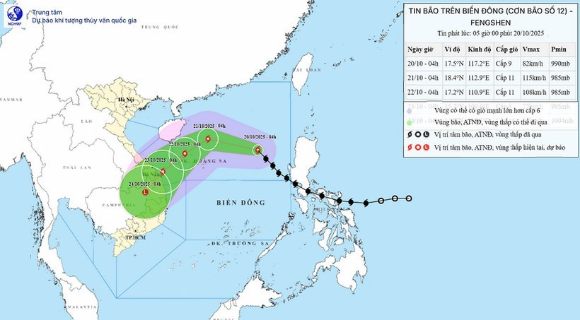
Hanoi (VNA) – Typhoon Fengshen, the 12th storm to enter in the East Sea so far this year, has changed its direction and is likely to strengthen, though its current intensity remains stable, showed data from the National Centre for Hydro-Meteorological Forecasting.

At 4:00 on October 20, the storm’s centre was located at 17.5 degrees North latitude and 117.2 degrees East longitude, about 540 km northeast of Hoang Sa special zone. The strongest winds near the storm’s centre were at level 9 (75 – 88 km/h), with gusts reaching level 11. The storm was moving northwestward at about 25 km/h.

By 4:00 on October 21, the storm is forecast to be about 180 km north-northeast of Hoang Sa, with maximum wind speeds at levels 10 – 11, gusting up to level 13, moving west-northwest at around 20 km/h and likely to strengthen further.

By 4:00 on October 22, it will be located about 180 km northwest of Hoang Sa, maintaining level 10 – 11 winds, gusting to level 13, and moving southwestward at around 10 km/h. Affected areas include the western part of the northern East Sea (including Hoang Sa) and the waters off Thua Thien-Hue to Quang Ngai provinces. Disaster risk is expected to be be at level 3.

By 4:00 on October 23, the typhoon is expected to be in the waters from Thua Thien-Hue to Quang Ngai, with winds decreasing to level 8, gusting up to level 10, moving southwestward at about 10 km/h and likely to weaken further.

In the following 72 to 96 hours, Fengshen is expected to move mainly southwestward at about 10 km/h, gradually weakening into a tropical depression.

typhoon-fensheng-vna-2.jpg
Illustrative image (Source: VNA)

Due to its impact, the northern East Sea (including Hoang Sa) will experience strong winds of levels 7 – 8, increasing to levels 9 – 11 near the storm’s centre, with gusts up to level 13. Wave heights will range from 3 – 5 metres, peaking at 5 – 7 metres near the storm’s core, causing very rough seas.

All vessels operating in or near the affected areas are at risk from thunderstorms, whirlwinds, strong winds, and high waves.

On mainland, Fengshen’s circulation, combined with a cold air mass, easterly disturbances, and orographic effects, is expected to bring widespread and prolonged heavy rainfall from Ha Tinh to Quang Ngai provinces between October 22 and 27, with some areas likely to experience extremely heavy rain, posing a high risk of flash floods and landslides in mountainous regions. Local authorities are urged to prepare response plans for possible flooding at or above level 3 on rivers from Quang Tri to Quang Ngai.

On October 19, the Head of the National Civil Defence Steering Committee issued an official dispatch to the people’s committees of coastal provinces and cities from Quang Ninh to Lam Dong, and to the Ministries of National Defence, Public Security, Agriculture and Environment, Construction, Industry and Trade, Foreign Affairs, Science and Technology, as well as the Vietnam News Agency, Vietnam Television, and the Voice of Vietnam, urging them to take proactive measures in response to the typhoon.

The committee requested authorities to closely monitor the storm’s developments, strictly manage vessels going out to sea, prepare rescue forces and equipment, and enhance communication to ensure timely updates on the storm’s progress are delivered to local administrations, vessel owners, and residents to proactively respond./.

VNA

See more

Vice Chairman of the Hanoi People’s Committee Nguyen Manh Quyen receives Sylvain Ouillon, Chief Representative of the French National Research Institute for Sustainable Development (IRD) in Vietnam (Photo: Hanoi Moi)

Hanoi strengthens ties with IRD to tackle air pollution

Vice Chairman of the Hanoi People’s Committee Nguyen Manh Quyen on November 6 received Sylvain Ouillon, Chief Representative of the French National Research Institute for Sustainable Development (IRD) in Vietnam, to discuss potential cooperation in air quality monitoring and pollution reduction in the capital city.

Houses inundated by storm-triggered flooding. (Photo: VNA)

Central, Central Highlands localities race to recover from Storm Kalmaegi

According to Vietnam Disaster and Dyke Management Authority (VDDMA), the storm left five people dead and six injured. As of 7 a.m. on November 7, 52 houses had collapsed and 2,593 others were damaged or unroofed, including 2,412 in Gia Lai province. Nine fishing vessels were reported sunk.

High waves in Ly Son island, Quang Ngai province due to Typhoon Kalmaegi. (Photo: VNA)

Central, Central Highlands localities respond to Typhoon Kalmaegi

As Typhoon Kalmaegi, the 13th storm to hit the East Sea this year, intensifies and heads toward Vietnam’s central coast, localities across the central and Central Highlands regions, including Dak Lak, Lam Dong, Da Nang and Quang Ngai, have activated their highest-level disaster response measures to ensure the safety of people and property.

A map released at 2pm on November 4, tracking the path of Typhoon Kalmaegi (Source: National Centre for Hydro-Meteorological Forecasting)

PM urges proactive measures in response to Typhoon Kalmaegi

As Typhoon Kalmaegi is expected to enter the East Sea on the morning of November 5, with sustained winds of level 13–14 and gusts reaching level 17, Prime Minister Pham Minh Chinh has ordered ministries, sectors, and local authorities to implement the highest-level response measures to protect lives and minimise damage.

Residents in the buffer zone of the UNESCO-recognised Western Nghe An Biosphere Reserve (Photo: VNA)

Vietnam's World Biosphere Reserves eye to become ideal destinations

Vietnam's World Biosphere Reserves have truly become a rendezvous for integration, cooperation, and the exchange of information and experiences among countries and international organisations in the field of conservation and sustainable development, as well as an ideal destination for domestic and international tourists, heard a conference in the central province of Khanh Hoa on November 3.

Heavy rain and prolonged flooding have caused deep inundation, making transportation difficult. (Photo: VNA)

Heavy downpours, floods leave 37 dead, five missing

In addition, floods have submerged and damaged 7,897 hectares of paddy and crops, and 64,356 livestock and poultry have died or been swept away. Across the nation, 103 houses have collapsed or been washed away, 451 others damaged, and 12,676 flooded.

Heavy rain causes severe flooding on many roads across Nghe An province on November 3. (Photo: VNA)

Storm Kalmaegi intensifies, authorities warn of flooding and landslides

From early November 3 to late November 4, areas from Ha Tinh to Da Nang and eastern Quang Ngai are expected to experience very heavy rainfall — 200–300mm on average, and up to 600mm in some places. Areas in Ha Tinh province, the northern part of Quang Tri province, and the eastern part of Quang Ngai province may see 100–200mm of rain, with localised totals exceeding 350mm.

Farmers harvest rice in the Mekong Delta. (Photo: VNA)

Agricultural sector to cut at least 15% greenhouse gas emissions by 2035

The project on low-emission crop production for the period for 2025-2035, with a vision extending to 2050, focuses on high-emission crops such as rice, cassava, sugarcane, coffee, and bananas. It aims to pilot at least 15 farming models nationwide that are ready for carbon credits and meet international standards.

Soldiers transport rice to distribute to flood-hit residents on October 31. (Photo: VNA)

PM orders urgent support for flood-hit localities

To ensure residents' safety and prevent hunger and disease outbreaks, the PM asked the Minister of Finance to immediately allocate rice from national reserves to flood-hit communities, based on requests from provincial authorities, including Quang Ngai. Implementation results should be reported to the PM by October 31.

High tides hit many areas in Can Tho city. (Photo: VNA)

JICA provides over 9 billion VND to help Can Tho improve drainage system

Japan's Fukuoka city will share its experience and advanced technologies to help Can Tho tackle three major issues: flood damage and untreated wastewater discharge, inefficient management of wastewater treatment plants, and low public awareness about connecting private drains to public systems.

The rising water level on Ve river (Photo: VNA)

Central Vietnam hit by torrential rains till late October

The deluge stems from a combination of atmospheric factors, including a low-altitude cold air mass, a northward movement of the intertropical convergence zone and humid easterly winds at elevations between 1,500m and 5,000m, NCHMF Director Assoc. Prof Mai Van Khiem said, adding that this configuration is a classic driver of prolonged, high-intensity rainfall in the region.