Typhoon Kalmaegi to bring torrential rain to central region over next two days

Kalmaegi is a strong and fast-moving storm with a broad circulation, with a track and pattern of impact similar to Typhoon Damrey (2017) and Typhoon Molave (2020).

Prolonged heavy rain from the night of November 2 to the morning of November 3, 2025, caused severe flooding across several areas of Da Nang city, leading to traffic congestion and difficult travel conditions in certain places. (Photo: VNA)

Hanoi (VNA) – Under the influence of Typhoon Kalmaegi – the 13th storm in the East Sea this year, extremely heavy rain is forecast for areas from Da Nang city to Dak Lak province in the central region on November 6 and 7, with rainfall expected to reach 200 – 400mm, and in some places over 600mm.

During the same period, the areas from southern Quang Tri to Hue, Khanh Hoa, and Lam Dong are likely to experience heavy rain, with totals ranging from 150–300mm, locally exceeding 450mm, according to the National Centre for Hydro-Meteorological Forecasting (NCHMF).

Downpour is expected to ease from November 8, though northern Quang Tri to Thanh Hoa will see moderate to heavy rain of 50–150mm, with some areas possibly exceeding 200mm. Intense rainfall of over 200mm per three hours are also predicted.

Due to the storm’s wide circulation, authorities have warned of thunderstorms, strong gusts, and tornadoes both before and during landfall.

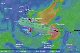
Mai Van Khiem, Director of the NCHMF, noted that Kalmaegi is a strong and fast-moving storm with a broad circulation, with a track and pattern of impact similar to Typhoon Damrey (2017) and Typhoon Molave (2020).

At 10:00 on November 5, Kalmaegi's eye was at about 11.6 degrees North and 118.4 degrees East, some 450km east of Song Tu Tay Island. The storm sustained the strongest winds of Levels 13–14 (134–166 km/k), gusting up to Level 17. It was moving west-northwest at about 20km/h.

As of 10:00 on November 6, it is forecast to be about 340km east-southeast of Quy Nhon (Gia Lai province), packing winds of Level 14, with gusts of Level 17, moving west-northwest at around 25km/h. It is expected to affect the central part of the East Sea, including northern Truong Sa (Spratly) waters, with a disaster risk level of 4.

By 22:00 on the same day, Kalmaegi will be on Quang Ngai – Dak Lak waters, sustaining Level-13 winds, gusting to Level 16, still moving west-northwest at 25km/h. The affected areas include the western central East Sea, Quang Ngai – Dak Lak waters (including the Ly Son special zone) and coastal zones from southern Quang Tri to Da Nang, all at disaster risk levels 3–4.

At 10:00 on November 7, the storm is expected to hit southern Laos, gradually weakening to a tropical depression with Level-7 winds, gusting to Level 9. By 22:00 the same day, it will have moved into Thailand, with winds below Level 6, and continue to weaken.

quang-tri-typhoon-kalmaegi-to-bring-torrential-rain-to-central-region-over-next-two-days-vna.jpg
Many roads in Quang Tri province have suffered severe landslides, disrupting traffic and posing risks to local residents. (Photo: VNA)

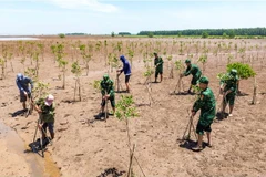
In response to Kalmaegi’s complex developments, Dak Lak province has issued a ban on all fishing and marine activities from 06:00 on November 5. The provincial Department of Education and Training has ordered schools in coastal communes likely to be directly affected to close from the afternoon of November 5 until November 7.

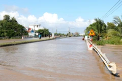
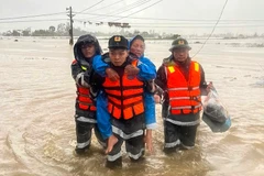
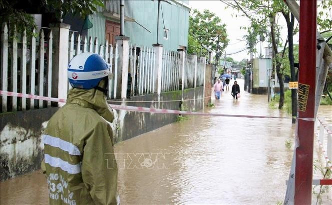
Meanwhile, Quang Tri province has directed localities and agencies to actively implement emergency response measures. Meanwhile, efforts are also being made to address the aftermath of the recent widespread flooding, including environmental clean-up, disinfection, infrastructure restoration, and free medical treatment for the injured. Authorities are identifying households in need of food and shelter and preparing to evacuate residents from high-risk areas threatened by landslides, flash floods, and deep inundation, with particular attention to vulnerable groups.

As of 06:00 on November 5, flooding in Quang Tri had resulted in nine deaths, one person missing, and four injured. The province reported 71 flooded sites, 40 landslide-hit locations, over 10,900 inundated households (more than 23,300 people), and 433 others (over 1,300 residents) isolated by floodwaters. Sixty-five schools were forced to suspend classes, affecting over 17,700 students./.

VNA

See more

Official heritage plaque i sinstalled on the 12 recognised Shan Tuyet tea trees in Dong Phuc commune. (Photo: VNA)

Thai Nguyen: 12 ancient Shan Tuyet tea trees win national heritage status

The recognition honours the biological, cultural and historical values of these centuries-old Shan Tuyet tea trees – natural treasures deeply woven into the livelihoods, traditions and identity of local ethnic communities. The title affirms the community’s commitment to preserving and promoting the value of this iconic local tea variety.

Sarus cranes at Tram Chim National Park (Photo: VNA)

Return of sarus cranes: Hope takes wing in Dong Thap wetland

Beneath the wide Mekong Delta sky, Tram Chim National Park is racing against time, pouring heart and science into a decade-long (2022–2032) plan to rescue the Eastern sarus crane – an elegant, scarlet-headed bird listed as endangered on the International Union for the Conservation of Nature (IUCN) Red List and a living emblem of both the park and all of Dong Thap province

French Ambassador Olivier Brochet speaks at the press conference in Hanoi on December 11 to mark the 10th anniversary of the Paris Agreement on climate change and highlighting the COP30 outcomes. (Photo: VNA)

International community ready to support Vietnam in energy transition, climate response

In a video message to the press conference, UN Resident Coordinator in Vietnam Pauline Tamesis said the UN is ready to support Vietnam in building a pipeline of projects capable of absorbing financing mobilised under the Political Declaration on establishing the Just Energy Transition Partnership (JETP), as well as from global climate finance sources, including the Green Climate Fund and the Loss and Damage Fund.

Forest rangers in Son La province apply technological devices and software to forest management, monitoring, and protection. (Photo: nhandan.vn)

Digital technology application enhances forest management, protection

With a total forest area of over 14 million hectares, including more than 10 million hectares of natural forests, forests exist in all 34 provinces and cities across the country. Given the large area and limited workforce, applying digital solutions in forest management and protection has become a top priority for the forestry sector.

Sunda pangolins (Manis javanica), also known as the Javan pangolin, are listed in Group IB – critically endangered and strictly protected from all commercial exploitation (Photo: VNA)

Quang Ngai releases rare pangolin back into nature

Initial verification showed that the animal weighed 3.7kg and measured over 60cm. It was identified as a Sunda pangolin (Manis javanica), also known as the Javan pangolin, listed in Group IB – critically endangered and strictly protected from all commercial exploitation.

Residents of Tuyen Quang province take part in the One Billion Trees Programme. (Photo: VNA)

Tree-planting programme exceeds one-billion-tree goal

The total comprises 573.9 million scattered trees and 865.2 million trees grown in concentrated plantations, equivalent to 429,125 hectares of forest. Provinces posting the strongest results include Phu Tho with 177.9 million trees, Lao Cai with 108.8 million, and An Giang with 98.5 million.

Construction activity is one of the causes of air pollution in Hanoi. (Photo: VNA)

Hanoi takes urgent measures to curb air pollution

The city requires the enhanced application of advanced technologies and remote monitoring systems, including satellite remote sensing, drones, and AI-integrated traffic cameras, to monitor, detect, and strictly address the illegal burning of garbage, straw, and agricultural by-products.