Phu Quoc marine protected area: harmony between conservation and development

The Phu Quoc marine protected area (MPA), part of the Phu Quoc National Park, is located in the waters of Phu Quoc island district, the southern province of Kien Giang. It was established in 2007, and is among 11 marine protected areas in Vietnam at present.
Phu Quoc marine protected area: harmony between conservation and development ảnh 1
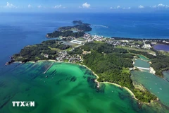
A bird’s-eye view of the fishing ground to the northeast of Phu Quoc Island (Photo: VNA)

Hanoi (VNA) – The Phu Quoc marine protected area (MPA), part of the Phu Quoc National Park, is located in the waters of Phu Quoc island district, the southern province of Kien Giang. It was established in 2007, and is among 11 marine protected areas in Vietnam at present.

Considering an increasing number of tourists to Phu Quoc and the over-exploitation of local fishery resources, the local government local government is looking for effective solutions to complete the two major tasks of conserving nature and serving tourism development.

A rich eco-system

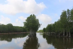
The Phu Quoc MPA, covering 26,863 ha, is home to many types of ecosystems such as coral reefs, seagrass meadows and mangrove swamps, which provide habitats for various rare and precious fauna and flora species.

The MPA comprises 9,720 ha of coral reefs in Hon Thom islet group, 6,825 ha of seagrass meadows spreading over waters from Bai Thom and Ham Ninh communes, and over 10,000 ha of development area.

The Phu Quoc MPA plays an important role in restoring and developing fisheries resources, developing the local marine economy, thus contributing to improving livelihoods for communities in coastal and island areas, as well as to scientific research, community-based education, eco-tourism and environmental protection.

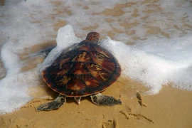
The coral reefs and seagrass meadows provide habitats for numerous types of fish and other sea animals such as sea horse, crab, or sea turtle. It is noteworthy that the waters are home to many rare and precious species that have been listed in the International Union for Conservation of Nature (IUCN) Red List of Threatened Species, for example Dugong, sea turtle and dolphin, to name just a few. Thanks to good conservation work, the number of such rare and precious sea animals has been on an upward trend over recent years.

Phu Quoc marine protected area: harmony between conservation and development ảnh 2Dugon (Source: glogster.com)

However, surveys of scientists have shown that the marine resources in Phu Quoc waters have gradually become depleted, the sea grass meadow ecosystem has undergone changes and water near the shore has been polluted, affecting the habitats and food sources of marine species.

The major factors leading to the worrying situation include rapid population growth, over-exploitation, use of backward fishing methods and low awareness among local communities.

Working towards sustainable development

In implementing the strategy for sustainable development of maritime economy towards 2030 with a vision to 2045, the provincial People’s Committee said it is urgent to conduct surveys on biodiversity in Phu Quoc and adjust the sub-zones in the Phu Quoc marine protected area.

The provincial authorities have instructed the Department of Agriculture and Rural Development to tighten fisheries management in the marine protected area and intensify the enforcement of the Law on Fisheries.

The department will promote the dissemination of regulations on marine species subject to ban of exploitation, as well as rules on fishing means, vehicles, fishing seasons and fishing grounds in order to protect the marine resources.

A buffer zone of more than 12,467ha will be set up to limit the direct impacts of outside socio-economic activities on the conservation areas.

The provincial administration has also directed the Phu Quoc National Park to strengthen the conservation, restoration and development of marine ecosystems and sea plants and animals.

The park will coordinate with relevant agencies and the People’s Committee of Phu Quoc district to implement programmes and projects to help people living in the marine protected areas to switch to other jobs. The agencies are required to provide vocational training to local fishermen and transfer scientific-technical advances to them with a view to helping them shift to sustainable fishing.

Meanwhile, the Tourism Department is tasked with managing and guiding suitable tourism activities in the marine protected area.

Phu Quoc marine protected area: harmony between conservation and development ảnh 3
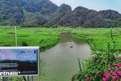
A beach on Phu Quoc Island (Photo: VNA) 

In 2018, Phu Quoc welcomed more than 4 million tourists, a year-on-year rise of some 36 percent./.

VNA

See more

Vice Chairman of the Hanoi People’s Committee Nguyen Manh Quyen receives Sylvain Ouillon, Chief Representative of the French National Research Institute for Sustainable Development (IRD) in Vietnam (Photo: Hanoi Moi)

Hanoi strengthens ties with IRD to tackle air pollution

Vice Chairman of the Hanoi People’s Committee Nguyen Manh Quyen on November 6 received Sylvain Ouillon, Chief Representative of the French National Research Institute for Sustainable Development (IRD) in Vietnam, to discuss potential cooperation in air quality monitoring and pollution reduction in the capital city.

Houses inundated by storm-triggered flooding. (Photo: VNA)

Central, Central Highlands localities race to recover from Storm Kalmaegi

According to Vietnam Disaster and Dyke Management Authority (VDDMA), the storm left five people dead and six injured. As of 7 a.m. on November 7, 52 houses had collapsed and 2,593 others were damaged or unroofed, including 2,412 in Gia Lai province. Nine fishing vessels were reported sunk.

High waves in Ly Son island, Quang Ngai province due to Typhoon Kalmaegi. (Photo: VNA)

Central, Central Highlands localities respond to Typhoon Kalmaegi

As Typhoon Kalmaegi, the 13th storm to hit the East Sea this year, intensifies and heads toward Vietnam’s central coast, localities across the central and Central Highlands regions, including Dak Lak, Lam Dong, Da Nang and Quang Ngai, have activated their highest-level disaster response measures to ensure the safety of people and property.

A map released at 2pm on November 4, tracking the path of Typhoon Kalmaegi (Source: National Centre for Hydro-Meteorological Forecasting)

PM urges proactive measures in response to Typhoon Kalmaegi

As Typhoon Kalmaegi is expected to enter the East Sea on the morning of November 5, with sustained winds of level 13–14 and gusts reaching level 17, Prime Minister Pham Minh Chinh has ordered ministries, sectors, and local authorities to implement the highest-level response measures to protect lives and minimise damage.

Residents in the buffer zone of the UNESCO-recognised Western Nghe An Biosphere Reserve (Photo: VNA)

Vietnam's World Biosphere Reserves eye to become ideal destinations

Vietnam's World Biosphere Reserves have truly become a rendezvous for integration, cooperation, and the exchange of information and experiences among countries and international organisations in the field of conservation and sustainable development, as well as an ideal destination for domestic and international tourists, heard a conference in the central province of Khanh Hoa on November 3.

Heavy rain and prolonged flooding have caused deep inundation, making transportation difficult. (Photo: VNA)

Heavy downpours, floods leave 37 dead, five missing

In addition, floods have submerged and damaged 7,897 hectares of paddy and crops, and 64,356 livestock and poultry have died or been swept away. Across the nation, 103 houses have collapsed or been washed away, 451 others damaged, and 12,676 flooded.

Heavy rain causes severe flooding on many roads across Nghe An province on November 3. (Photo: VNA)

Storm Kalmaegi intensifies, authorities warn of flooding and landslides

From early November 3 to late November 4, areas from Ha Tinh to Da Nang and eastern Quang Ngai are expected to experience very heavy rainfall — 200–300mm on average, and up to 600mm in some places. Areas in Ha Tinh province, the northern part of Quang Tri province, and the eastern part of Quang Ngai province may see 100–200mm of rain, with localised totals exceeding 350mm.

Farmers harvest rice in the Mekong Delta. (Photo: VNA)

Agricultural sector to cut at least 15% greenhouse gas emissions by 2035

The project on low-emission crop production for the period for 2025-2035, with a vision extending to 2050, focuses on high-emission crops such as rice, cassava, sugarcane, coffee, and bananas. It aims to pilot at least 15 farming models nationwide that are ready for carbon credits and meet international standards.

Soldiers transport rice to distribute to flood-hit residents on October 31. (Photo: VNA)

PM orders urgent support for flood-hit localities

To ensure residents' safety and prevent hunger and disease outbreaks, the PM asked the Minister of Finance to immediately allocate rice from national reserves to flood-hit communities, based on requests from provincial authorities, including Quang Ngai. Implementation results should be reported to the PM by October 31.

High tides hit many areas in Can Tho city. (Photo: VNA)

JICA provides over 9 billion VND to help Can Tho improve drainage system

Japan's Fukuoka city will share its experience and advanced technologies to help Can Tho tackle three major issues: flood damage and untreated wastewater discharge, inefficient management of wastewater treatment plants, and low public awareness about connecting private drains to public systems.