Super typhoon Ragasa to enter East Sea on September 23

The eastern part of the northern East Sea will see winds gradually strengthening from Level 8–9 to Level 10–14, and near the storm’s eye reaching Level 15–17 with gusts above Level 17.

Forecast of the movement direction of super Typhoon Ragasa. (Photo: nchmf.gov.vn)

Hanoi (VNA) – Super Typhoon Ragasa continues to intensify as it approaches the East Sea, bringing powerful winds, towering waves, and warnings of flash floods and landslides in northern mountainous provinces of Vietnam.

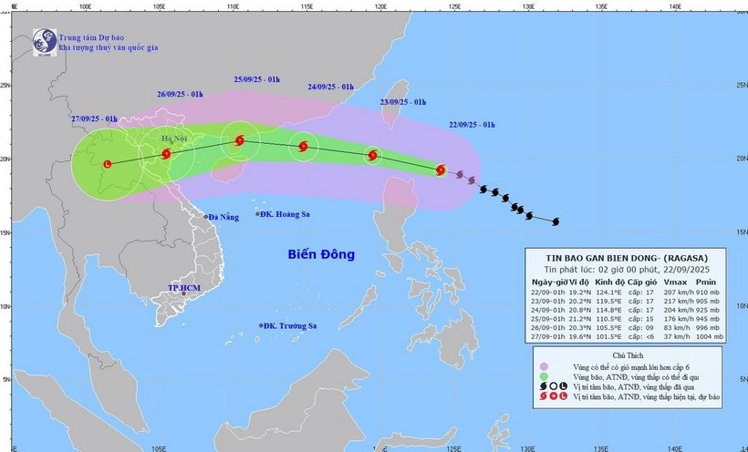
At 7 am on September 22, the storm’s eye was located at 19.3 degrees North latitude and 123.1 degrees East longitude, about 160 km northeast of Luzon Island in the Philippines. Ragasa packed maximum winds of 202–221 km per hour (equivalent to Level 17 on Vietnam’s wind scale), with gusts exceeding Level 17, and was moving west-northwest at around 20 km per hour, according to the National Centre for Hydro-Meteorological Forecasting.

By 7 am on September 23, Ragasa is forecast to be in the northeastern region of the northern East Sea with sustained winds of Level 17, gusting above Level 17. It will likely continue to strengthen as it tracks west-northwest at 20 km per hour and enters East Sea. Disaster risk level has been set at Category 4, the second-highest warning.

By 7 am on September 24, the storm is expected to be about 370km east of China’s Leizhou Island, maintaining winds of Level 16–17 and gusts of over Level 17; moving west-northwest at 20 km per hour.

song-bien-23122021-8260.jpg
All vessels in the affected waters face very high risks from squalls, strong winds, and high seas. (Illustrative photo: VNA)

By 7 am about September 25, Ragasa is predicted to weaken to Level 13–14 with gusts exceeding Level 17. It will continue moving west at 15–20 km per hour before gradually abating.

Associate Professor Dr. Mai Van Khiem, Director of the forecasting centre, warned that the eastern part of the northern East Sea will see winds gradually strengthening from Level 8–9 to Level 10–14, and near the storm’s eye reaching Level 15–17 with gusts above Level 17. Waves could rise over 10 metres, making the sea extremely rough. All vessels in the affected waters face very high risks from squalls, strong winds, and high seas./.

VNA

See more

Air pollution in Hanoi. (Photo: VNA)

Hanoi to launch 5,000 public electric bicycles

In a move to reduce air pollution and promote green mobility, Hanoi has approved a plan to deploy 5,000 public electric bicycles, alongside restrictions on petrol- and diesel-powered vehicles in the city’s central area.

Official heritage plaque i sinstalled on the 12 recognised Shan Tuyet tea trees in Dong Phuc commune. (Photo: VNA)

Thai Nguyen: 12 ancient Shan Tuyet tea trees win national heritage status

The recognition honours the biological, cultural and historical values of these centuries-old Shan Tuyet tea trees – natural treasures deeply woven into the livelihoods, traditions and identity of local ethnic communities. The title affirms the community’s commitment to preserving and promoting the value of this iconic local tea variety.

Sarus cranes at Tram Chim National Park (Photo: VNA)

Return of sarus cranes: Hope takes wing in Dong Thap wetland

Beneath the wide Mekong Delta sky, Tram Chim National Park is racing against time, pouring heart and science into a decade-long (2022–2032) plan to rescue the Eastern sarus crane – an elegant, scarlet-headed bird listed as endangered on the International Union for the Conservation of Nature (IUCN) Red List and a living emblem of both the park and all of Dong Thap province

French Ambassador Olivier Brochet speaks at the press conference in Hanoi on December 11 to mark the 10th anniversary of the Paris Agreement on climate change and highlighting the COP30 outcomes. (Photo: VNA)

International community ready to support Vietnam in energy transition, climate response

In a video message to the press conference, UN Resident Coordinator in Vietnam Pauline Tamesis said the UN is ready to support Vietnam in building a pipeline of projects capable of absorbing financing mobilised under the Political Declaration on establishing the Just Energy Transition Partnership (JETP), as well as from global climate finance sources, including the Green Climate Fund and the Loss and Damage Fund.

Forest rangers in Son La province apply technological devices and software to forest management, monitoring, and protection. (Photo: nhandan.vn)

Digital technology application enhances forest management, protection

With a total forest area of over 14 million hectares, including more than 10 million hectares of natural forests, forests exist in all 34 provinces and cities across the country. Given the large area and limited workforce, applying digital solutions in forest management and protection has become a top priority for the forestry sector.

Sunda pangolins (Manis javanica), also known as the Javan pangolin, are listed in Group IB – critically endangered and strictly protected from all commercial exploitation (Photo: VNA)

Quang Ngai releases rare pangolin back into nature

Initial verification showed that the animal weighed 3.7kg and measured over 60cm. It was identified as a Sunda pangolin (Manis javanica), also known as the Javan pangolin, listed in Group IB – critically endangered and strictly protected from all commercial exploitation.

Residents of Tuyen Quang province take part in the One Billion Trees Programme. (Photo: VNA)

Tree-planting programme exceeds one-billion-tree goal

The total comprises 573.9 million scattered trees and 865.2 million trees grown in concentrated plantations, equivalent to 429,125 hectares of forest. Provinces posting the strongest results include Phu Tho with 177.9 million trees, Lao Cai with 108.8 million, and An Giang with 98.5 million.

Construction activity is one of the causes of air pollution in Hanoi. (Photo: VNA)

Hanoi takes urgent measures to curb air pollution

The city requires the enhanced application of advanced technologies and remote monitoring systems, including satellite remote sensing, drones, and AI-integrated traffic cameras, to monitor, detect, and strictly address the illegal burning of garbage, straw, and agricultural by-products.