Typhoon Bualoi moving quickly towards East Sea

By 7:00 on September 28, Typhoon Bualoi’s centre will continue moving west-northwest at around 30 km/h and may strengthen further. The affected areas will include the northern and central East Sea, including Vietnam's Hoang Sa, and the waters from southern Quang Tri to Quang Ngai.

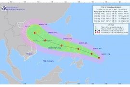
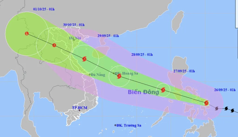
Forecast of Typhoon Bualoi’s position and movement direction at 1:00 on September 26. (Photo: National Centre for Hydro-Meteorological Forecasting)

Hanoi (VNA) - Typhoon Bualoi is moving quickly towards the East Sea and is forecast to enter the eastern waters of the central East Sea around the night of September 26, becoming the tenth storm entering the sea this year, according to Deputy Director of the National Centre for Hydro-Meteorological Forecasting Hoang Phuc Lam.

At 7:00 on September 26, the storm’s centre was located at approximately 12.2 degrees North latitude and 123.3 degrees East longitude, over the central region of the Philippines. The strongest winds near the storm’s eye reached level 11 (103-117 km/h), with gusts up to level 14. The storm was moving west-northwestern at a speed of about 30 km/h.

By 7:00 the following day, the storm will move west-northwest in the East Sea at a speed of 30-35 km/h, and is expected to intensify. The affected areas will be the eastern parts of the northern and central East Sea. The disaster risk is at level 3.

By 7:00 on September 28, the storm’s centre will continue moving west-northwest at around 30 km/h and may strengthen further. The affected areas will include the northern and central East Sea, including Vietnam's Hoang Sa, and the waters from southern Quang Tri to Quang Ngai.

By 7:00 on September 29, the storm’s centre will move west-northwest at around 25 km/h. The affected areas will include the western parts of the northern and central East Sea, including Hoang Sa, the southern Gulf of Tonkin, and the waters from southern Quang Tri to Quang Ngai.

Over the following 72 to 120 hours, it is forecast to continue moving quickly west-northwest at a speed of about 25 km/h, gradually weakening in intensity.

Due to the storm’s impact, from September 26 afternoon, the eastern areas of the northern and central East Sea will experience strong winds of level 6-7, later increasing to level 8-9; areas near the storm’s centre will see winds of level 10-12 with gusts up to level 15. Wave heights will range from 5 to 7 metres, with extremely rough seas.

All vessels operating in the above dangerous areas will be exposed to thunderstorms, whirlwinds, strong winds, and high waves./.
VNA

See more

White-rumped langurs are rescued and conserved at the Endangered Primate Rescue Centre (EPRC) in Cuc Phuong National Park. (Photo: VNA)

Ninh Binh establishes Kim Bang white-rumped langur conservation area

Covering a total area of 3,182ha, the conservation area comprises 3,016.81ha of natural forest, 64.25ha of plantation forest and 100.94ha of land without forest, with no water surface area. It is located in the Ly Thuong Kiet, Tam Chuc and Nguyen Uy wards of Ninh Binh province.

The forum takes place in Hanoi on August 25, 2026. (Photo: VNA)

Vietnam, RoK promote cooperation to deliver on net-zero commitments

Sectors such as semiconductor manufacturing, nuclear power, science and advanced technologies are playing an increasingly important role in national competitiveness and economic development of each country. They also offer considerable room for Vietnam and the RoK to expand professional exchanges, share experience and promote cooperation, particularly among their energy experts.

Storm Narra's projected path as of 7:00 on August 22. (Photo: National Centre for Hydro-Meteorological Forecasting)

Storm brings heavy rains to northern Vietnam

Storm Narra, the fourth to hit the East Sea this year, brought strong winds and heavy rains to northern Vietnam on early August 22, with some areas forecast to receive more than 500mm of rain as the storm moves slowly over the northern waters of the East Sea.

A view of the meeting between Phu Tho authorities and a visiting delegation from Germany's KfW Development Bank in the province on August 20, 2026. (Photo: VNA)

Phu Tho, German bank discuss wastewater treatment plan for Da River's left bank

The project is being implemented in the former Hoa Binh city, now Hoa Binh ward. It has a total investment of 688.7 billion VND (26.38 million USD), including 507.3 billion VND in ODA and 181.4 billion VND in counterpart funding. Major components include a wastewater treatment plant, pumping stations, a collection network, and connection infrastructure.

Construction workers reinforce steel and pour concrete to cover the underground drainage channel, helping collect rainwater and tackle flooding in Da Nang. (Photo: VNA)

A new “shield” against climate change

Smart urban areas are no longer simply about technology; they are becoming a tool that enables authorities to forecast risks, adapt quickly and protect their residents.

Vietnam is exerting efforts to cope with climate change. (Illustrative photo: VNA)

Vietnam approves carbon credit pact with Singapore under Paris Agreement

Signed on September 16, 2025, the Implementation Agreement on carbon credits collaboration under Article 6 of the Paris Agreement on climate change affirms Vietnam and Singapore’s pioneering role and commitment to close cooperation in the international carbon market, making a substantive contribution to global climate response.

A view of Vo Cuong ward, Bac Ninh province (Photo: VNA)

Bac Ninh earmarks over 1.7 billion USD for environmental protection

By 2030, Bac Ninh aims to ensure that all operating industrial clusters and industrial parks have centralised wastewater treatment systems meeting standards, while at least 95% of wastewater in Grade-I urban areas and 70% in Grade-II urban areas is collected and treated to required standards.