Typhoon Kalmaegi moves faster, now about 310 km from Quy Nhon

By 7 a.m. on November 7, the storm is expected to continue moving west-northwest, make landfall, and weaken into a tropical depression over southern Laos.

A map released at 5am on November 6, 2025, tracing the direction of Typhoon Kalmaegi (Photo published by VNA)

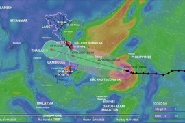
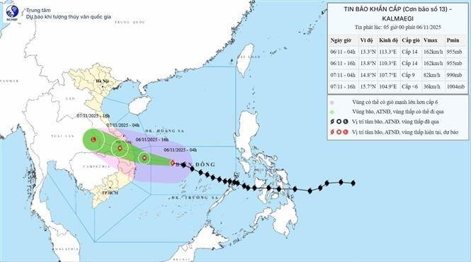
Hanoi (VNA) – Typhoon Kalmaegi, the 13th storm in the East Sea this year, has maintained its direction and intensity but is moving faster, with its centre located approximately 310 km east-southeast of Quy Nhon (Gia Lai province), according to the National Centre for Hydro-Meteorological Forecasting (NCHMF).

At 8 a.m. on November 6, the storm’s centre was positioned at latitude 13.2°N and longitude 112.3°E, about 310 km east-southeast of Quy Nhon, with maximum sustained winds near the eye reaching Level 14 (150–166 km/h) and gusts up to Level 17. The storm is moving west-northwest at around 30 km/h.

By 7 p.m. on November 6, Kalmaegi is forecast to be near latitude 14.0°N and longitude 109.4°E, over coastal areas between Quang Ngai and Dak Lak, sustaining maximum winds of Level 13–14 and gusting up to Level 17. The disaster risk level is assessed at 4 for the central East Sea, waters from Quang Ngai to Dak Lak, and inland areas east of Quang Ngai to Gia Lai.

By 7 a.m. on November 7, the storm is expected to continue moving west-northwest, make landfall, and weaken into a tropical depression over southern Laos, with winds dropping to Level 7 and gusts up to Level 9. By 7 p.m. the same day, the tropical depression will move into eastern Thailand and further abate into a low-pressure area with winds below Level 6.

Over the East Sea, the central region will experience strong winds of Level 8–11, increasing to 12–14 near the storm’s centre, with gusts up to Level 17. Waves will reach 5–7 metres, and up to 8–10 metres near the storm’s eye, causing very rough seas.

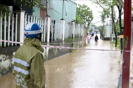
Along the sea areas from southern Quang Tri to Dak Lak, sea levels may rise by 0.4–0.8 m, posing risks of flooding in low-lying zones, seawater overtopping dykes, coastal erosion, and delayed flood drainage. All vessels and aquaculture operations within the danger zone will be heavily affected by thunderstorms, whirlwinds, strong winds, and high waves.

On land, from the afternoon of November 6, areas from southern Da Nang to Dak Lak will experience strengthening winds of Level 6–7, increasing to 8–9; areas near the storm’s centre (particularly eastern Quang Ngai – Gia Lai) will see winds of Level 10–12 and gusts of 14–15, accompanied by widespread heavy rainfall.

Between November 6 and 7, regions from Da Nang to Dak Lak are forecast to witness very heavy rainfall, ranging from 200–400 mm, with some areas exceeding 600 mm. From southern Quang Tri to Hue, as well as in Khanh Hoa and Lam Dong, rainfall will range from 150–300 mm, with certain areas exceeding 450 mm.

The centre warned of a high risk of extreme rainfall exceeding 200 mm within three hours, whirlwinds, and strong gusts before and during the storm’s landfall, particularly in areas between Da Nang and Khanh Hoa.

Kalmaegi is said to share several similarities with two major storms, Damrey (2017) and Molave (2020), but differs in wind intensity and higher rainfall. Areas from Da Nang to Dak Lak are warned of exceptionally heavy rainfall, potentially exceeding 600 mm per spell.

NCHMF Director Mai Van Khiem said compared to the previous storms, Kalmaegi is expected to cause more localised heavy rainfall than Damrey and Molave, but will likely not result in major flooding as experienced after Storm Fengshen, the 12th in the East Sea in 2025./.

VNA

See more

Official heritage plaque i sinstalled on the 12 recognised Shan Tuyet tea trees in Dong Phuc commune. (Photo: VNA)

Thai Nguyen: 12 ancient Shan Tuyet tea trees win national heritage status

The recognition honours the biological, cultural and historical values of these centuries-old Shan Tuyet tea trees – natural treasures deeply woven into the livelihoods, traditions and identity of local ethnic communities. The title affirms the community’s commitment to preserving and promoting the value of this iconic local tea variety.

Sarus cranes at Tram Chim National Park (Photo: VNA)

Return of sarus cranes: Hope takes wing in Dong Thap wetland

Beneath the wide Mekong Delta sky, Tram Chim National Park is racing against time, pouring heart and science into a decade-long (2022–2032) plan to rescue the Eastern sarus crane – an elegant, scarlet-headed bird listed as endangered on the International Union for the Conservation of Nature (IUCN) Red List and a living emblem of both the park and all of Dong Thap province

French Ambassador Olivier Brochet speaks at the press conference in Hanoi on December 11 to mark the 10th anniversary of the Paris Agreement on climate change and highlighting the COP30 outcomes. (Photo: VNA)

International community ready to support Vietnam in energy transition, climate response

In a video message to the press conference, UN Resident Coordinator in Vietnam Pauline Tamesis said the UN is ready to support Vietnam in building a pipeline of projects capable of absorbing financing mobilised under the Political Declaration on establishing the Just Energy Transition Partnership (JETP), as well as from global climate finance sources, including the Green Climate Fund and the Loss and Damage Fund.

Forest rangers in Son La province apply technological devices and software to forest management, monitoring, and protection. (Photo: nhandan.vn)

Digital technology application enhances forest management, protection

With a total forest area of over 14 million hectares, including more than 10 million hectares of natural forests, forests exist in all 34 provinces and cities across the country. Given the large area and limited workforce, applying digital solutions in forest management and protection has become a top priority for the forestry sector.

Sunda pangolins (Manis javanica), also known as the Javan pangolin, are listed in Group IB – critically endangered and strictly protected from all commercial exploitation (Photo: VNA)

Quang Ngai releases rare pangolin back into nature

Initial verification showed that the animal weighed 3.7kg and measured over 60cm. It was identified as a Sunda pangolin (Manis javanica), also known as the Javan pangolin, listed in Group IB – critically endangered and strictly protected from all commercial exploitation.

Residents of Tuyen Quang province take part in the One Billion Trees Programme. (Photo: VNA)

Tree-planting programme exceeds one-billion-tree goal

The total comprises 573.9 million scattered trees and 865.2 million trees grown in concentrated plantations, equivalent to 429,125 hectares of forest. Provinces posting the strongest results include Phu Tho with 177.9 million trees, Lao Cai with 108.8 million, and An Giang with 98.5 million.

Construction activity is one of the causes of air pollution in Hanoi. (Photo: VNA)

Hanoi takes urgent measures to curb air pollution

The city requires the enhanced application of advanced technologies and remote monitoring systems, including satellite remote sensing, drones, and AI-integrated traffic cameras, to monitor, detect, and strictly address the illegal burning of garbage, straw, and agricultural by-products.