Typhoon Kalmaegi weakens over Gia Lai–Dak Lak, continues to bring torrential rain

Typhoon Kalmaegi has been causing widespread heavy rain from southern Quang Tri to Dak Lak, with rainfall ranging from 100 to 250mm, and in some areas exceeding 300mm.

Trees are uprooted and broken in Buon Ma Thuot city, Dak Lak province, due to the impact of the storm. (Photo published by VNA)

Hanoi (VNA) - As of the night of November 6, Typhoon Kalmaegi maintained its west-northwestward track but further weakened after making landfall in Gia Lai and Dak Lak provinces, according to the National Centre for Hydro-Meteorological Forecasting (NCHMF).

The storm has been causing widespread heavy rain from southern Quang Tri to Dak Lak, with rainfall ranging from 100 to 250mm, and in some areas exceeding 300mm.

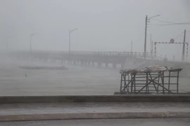
At 10 p.m., the storm’s centre was located over Gia Lai and Dak Lak provinces. The strongest winds near the centre reached level 9 (75–88 km/h), gusting to level 11. The storm was moving west-northwestward at about 30 km/h.

By 10 a.m. on November 7, it is forecast to move into southeastern Thailand, weakening into a tropical depression with wind speeds below level 6. The affected areas include the sea from the southern Da Nang to Dak Lak and mainland localities from Quang Ngai to Dak Lak, with a level-3 disaster risk warning.

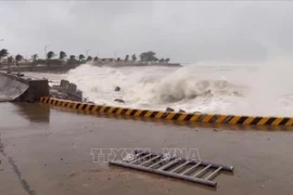
Authorities have warned of possible coastal flooding, storm surges, and high waves from Hue to Dak Lak, especially in low-lying areas. Coastal embankments, roads, and aquaculture zones may experience strong winds, rough seas, and rising tides, hampering drainage and increasing the risk of beach erosion. All vessels and aquaculture facilities in the affected areas are advised to take strict safety precautions.

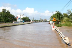
From the night of November 6 to 7, heavy to very heavy rainfall is expected from southern Quang Tri to Dak Lak (100–250mm, locally over 300mm), while Khanh Hoa and Lam Dong will experience 70–150mm, locally exceeding 250mm. Rainfall is forecast to decrease from November 8.

Between November 7 and 8, moderate to heavy rain is expected from Thanh Hoa to northern Quang Tri, with total rainfall ranging from 50–150mm, and some places receiving over 200mm. Rain intensity may reach over 200mm within three hours in some areas.

vna-potal-gio-giat-kinh-hoang-hon-5-tieng-nguoi-dan-quy-nhon-gong-minh-chong-bao-8391665.jpg
Roofs of houses in Quy Nhơn are torn off by powerful gusts after the storm made landfall. (Photo: VNA)

The NCHMF reported that from 11:30 p.m. on November 6 to 4:30 a.m. on November 7, provinces from Quang Tri to Lam Dong will continue to experience rain, posing a risk of flash floods and landslides. The disaster risk level for flash floods, landslides, and ground subsidence caused by heavy rain and runoff is level 1.

Flash floods and landslides could cause severe environmental damage, threaten human safety, disrupt traffic, and destroy residential and economic infrastructure, leading to losses in production and socio-economic activities.

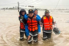
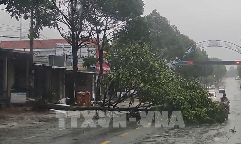
Following the storm’s landfall, Dak Lak province has reported initial damages. Local authorities and response forces have promptly deployed to key areas to assist residents and mitigate disaster impacts.

According to preliminary reports, Typhoon Kalmaegi has caused significant losses in Dak Lak, particularly in areas formerly under Song Cau township of Phu Yen province. During the night of November 6, the Ky Lo river rose rapidly as hydropower reservoirs released water, flooding several downstream localities in eastern Dak Lak. Military and police units have been dispatched to critical zones to support evacuation efforts and ensure the safety of residents./.

VNA

See more

Official heritage plaque i sinstalled on the 12 recognised Shan Tuyet tea trees in Dong Phuc commune. (Photo: VNA)

Thai Nguyen: 12 ancient Shan Tuyet tea trees win national heritage status

The recognition honours the biological, cultural and historical values of these centuries-old Shan Tuyet tea trees – natural treasures deeply woven into the livelihoods, traditions and identity of local ethnic communities. The title affirms the community’s commitment to preserving and promoting the value of this iconic local tea variety.

Sarus cranes at Tram Chim National Park (Photo: VNA)

Return of sarus cranes: Hope takes wing in Dong Thap wetland

Beneath the wide Mekong Delta sky, Tram Chim National Park is racing against time, pouring heart and science into a decade-long (2022–2032) plan to rescue the Eastern sarus crane – an elegant, scarlet-headed bird listed as endangered on the International Union for the Conservation of Nature (IUCN) Red List and a living emblem of both the park and all of Dong Thap province

French Ambassador Olivier Brochet speaks at the press conference in Hanoi on December 11 to mark the 10th anniversary of the Paris Agreement on climate change and highlighting the COP30 outcomes. (Photo: VNA)

International community ready to support Vietnam in energy transition, climate response

In a video message to the press conference, UN Resident Coordinator in Vietnam Pauline Tamesis said the UN is ready to support Vietnam in building a pipeline of projects capable of absorbing financing mobilised under the Political Declaration on establishing the Just Energy Transition Partnership (JETP), as well as from global climate finance sources, including the Green Climate Fund and the Loss and Damage Fund.

Forest rangers in Son La province apply technological devices and software to forest management, monitoring, and protection. (Photo: nhandan.vn)

Digital technology application enhances forest management, protection

With a total forest area of over 14 million hectares, including more than 10 million hectares of natural forests, forests exist in all 34 provinces and cities across the country. Given the large area and limited workforce, applying digital solutions in forest management and protection has become a top priority for the forestry sector.

Sunda pangolins (Manis javanica), also known as the Javan pangolin, are listed in Group IB – critically endangered and strictly protected from all commercial exploitation (Photo: VNA)

Quang Ngai releases rare pangolin back into nature

Initial verification showed that the animal weighed 3.7kg and measured over 60cm. It was identified as a Sunda pangolin (Manis javanica), also known as the Javan pangolin, listed in Group IB – critically endangered and strictly protected from all commercial exploitation.

Residents of Tuyen Quang province take part in the One Billion Trees Programme. (Photo: VNA)

Tree-planting programme exceeds one-billion-tree goal

The total comprises 573.9 million scattered trees and 865.2 million trees grown in concentrated plantations, equivalent to 429,125 hectares of forest. Provinces posting the strongest results include Phu Tho with 177.9 million trees, Lao Cai with 108.8 million, and An Giang with 98.5 million.

Construction activity is one of the causes of air pollution in Hanoi. (Photo: VNA)

Hanoi takes urgent measures to curb air pollution

The city requires the enhanced application of advanced technologies and remote monitoring systems, including satellite remote sensing, drones, and AI-integrated traffic cameras, to monitor, detect, and strictly address the illegal burning of garbage, straw, and agricultural by-products.