Typhoon Wipha enters northern Gulf of Tonkin

By 10:00 pm on July 21, the storm will remain in northern waters of the Gulf of Tonkin, potentially intensifying as it continues west-southwestward.

The position and movement direction of Typhoon Wipha from the disaster monitoring system as of 10:00 am on July 21, 2025. (Photo published by VNA)

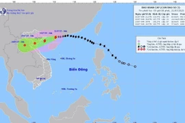
Hanoi (VNA) – Storm No. 3, internationally known as Typhoon Wipha, passed north of China’s Leizhou Peninsula on the morning of July 21 and entered the northern Gulf of Tonkin, posing a growing threat to Vietnam’s northern and north-central coastal regions, according to the National Centre for Hydro-Meteorological Forecasting.

At 10:00 am, the storm’s centre was positioned at around 21.2 degrees North and 109.6 degrees East, approximately 190km southeast of Quang Ninh, 310km east of Hai Phong, and 360km east-northeast of Ninh Binh. Maximum sustained winds near the storm’s centre reached Level 9 (75–88 km/h), with gusts up to Level 11. Wipha was moving west-southwest at a speed of 10–15 km/h.

Forecasts indicate that by 10:00 pm on July 21, the storm will remain in northern waters of the Gulf of Tonkin, potentially intensifying as it continues west-southwestward. Wind speeds may increase to Levels 10–11, with gusts reaching Level 14. Areas likely to be affected include northern parts of the East Sea, the Gulf of Tonkin, and inshore zones from Quang Ninh to Ninh Binh.

By 10 am on July 22, the storm will be on the waters between Hai Phong and Thanh Hoa, continuing in a west-southwest direction at 10–15 km/h. Wind warnings remain at Levels 10–11, with gusts up to Level 14. Coastal and inland regions from Quang Ninh to Nghe An are within the high-risk zone.

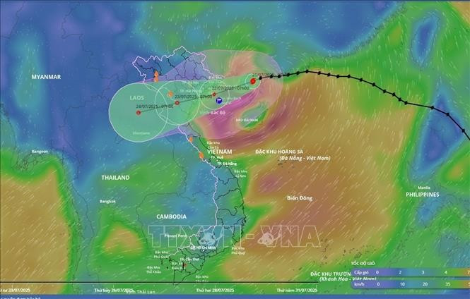
It is projected to be in northern Laos by 4 pm on July 23 and weaken into a low-pressure area.

Meteorologists warn that sea and coastal areas are in extreme danger, and all maritime vessels and structures in the storm’s path are unsafe. Boats and structures risk capsizing, damage, or submersion from strong winds, thunderstorms, tornadoes, and high waves.

From the evening of July 21, coastal areas from Quang Ninh to Nghe An are forecast to experience increasing winds of Levels 7–9, with gusts up to Level 11. In areas near the storm’s centre, gusts could reach Level 14. Inland areas, including those of Hai Phong, Hung Yen, Ninh Binh, and Thanh Hoa, may encounter wind levels of 6, gusting up to Levels 7–8.

Heavy rainfall is expected from July 21 through the night of July 22 across the Northeast, Red River Delta, and the north-central provinces of Thanh Hoa and Nghe An, with accumulations ranging from 170 to 280 mm, and some areas exceeding 450 mm. Other places in the North and central Ha Tinh province may record 80–160 mm, even over 250 mm.

Authorities warn of significant flooding risks in low-lying, urban, and industrial areas, especially in the Red River Delta, Thanh Hoa, and Nghe An. Flash floods in small streams and landslides on mountain slopes are also of concern. The Vietnam Meteorological and Hydrological Administration has activated real-time warnings for flash floods and landslides at https://luquetsatlo.nchmf.gov.vn.

Experts emphasise that landslides can continue to occur even after the storm has passed due to lingering soil saturation. Additionally, prolonged rainfall in the storm’s wake is forecast to continue affecting northern Vietnam and parts of northern Laos as the weather system broadens its influence./.

VNA

See more

Illustrative image (Photo: nhandan.vn)

20 trailblazing companies in national green ESG rankings honoured

In 2025-2026, the “For a Green National Environment” programme will pivot around six tasks that merge expertise with broad social outreach, including targeted communications, "Journey to Net Zero" conferences and trainings, ESG surveys and announcements, a "National Green Ambassador" contest, a "Green Fashion" design competition, and the rollout of "National Green Station" models focused on zero-waste living.

Air pollution in Hanoi. (Photo: VNA)

Hanoi to launch 5,000 public electric bicycles

In a move to reduce air pollution and promote green mobility, Hanoi has approved a plan to deploy 5,000 public electric bicycles, alongside restrictions on petrol- and diesel-powered vehicles in the city’s central area.

Official heritage plaque i sinstalled on the 12 recognised Shan Tuyet tea trees in Dong Phuc commune. (Photo: VNA)

Thai Nguyen: 12 ancient Shan Tuyet tea trees win national heritage status

The recognition honours the biological, cultural and historical values of these centuries-old Shan Tuyet tea trees – natural treasures deeply woven into the livelihoods, traditions and identity of local ethnic communities. The title affirms the community’s commitment to preserving and promoting the value of this iconic local tea variety.

Sarus cranes at Tram Chim National Park (Photo: VNA)

Return of sarus cranes: Hope takes wing in Dong Thap wetland

Beneath the wide Mekong Delta sky, Tram Chim National Park is racing against time, pouring heart and science into a decade-long (2022–2032) plan to rescue the Eastern sarus crane – an elegant, scarlet-headed bird listed as endangered on the International Union for the Conservation of Nature (IUCN) Red List and a living emblem of both the park and all of Dong Thap province

French Ambassador Olivier Brochet speaks at the press conference in Hanoi on December 11 to mark the 10th anniversary of the Paris Agreement on climate change and highlighting the COP30 outcomes. (Photo: VNA)

International community ready to support Vietnam in energy transition, climate response

In a video message to the press conference, UN Resident Coordinator in Vietnam Pauline Tamesis said the UN is ready to support Vietnam in building a pipeline of projects capable of absorbing financing mobilised under the Political Declaration on establishing the Just Energy Transition Partnership (JETP), as well as from global climate finance sources, including the Green Climate Fund and the Loss and Damage Fund.

Forest rangers in Son La province apply technological devices and software to forest management, monitoring, and protection. (Photo: nhandan.vn)

Digital technology application enhances forest management, protection

With a total forest area of over 14 million hectares, including more than 10 million hectares of natural forests, forests exist in all 34 provinces and cities across the country. Given the large area and limited workforce, applying digital solutions in forest management and protection has become a top priority for the forestry sector.

Sunda pangolins (Manis javanica), also known as the Javan pangolin, are listed in Group IB – critically endangered and strictly protected from all commercial exploitation (Photo: VNA)

Quang Ngai releases rare pangolin back into nature

Initial verification showed that the animal weighed 3.7kg and measured over 60cm. It was identified as a Sunda pangolin (Manis javanica), also known as the Javan pangolin, listed in Group IB – critically endangered and strictly protected from all commercial exploitation.

Residents of Tuyen Quang province take part in the One Billion Trees Programme. (Photo: VNA)

Tree-planting programme exceeds one-billion-tree goal

The total comprises 573.9 million scattered trees and 865.2 million trees grown in concentrated plantations, equivalent to 429,125 hectares of forest. Provinces posting the strongest results include Phu Tho with 177.9 million trees, Lao Cai with 108.8 million, and An Giang with 98.5 million.