Heavy rain and rising floods hit central region of Vietnam

From late October 26 to the early hours of October 27, areas stretching from Hue city to Quang Ngai province experienced heavy to extremely heavy rainfall, with some places recording over 100mm. The Bach Ma station in Hue measured 119.8mm, while the Rach Bun station in Dong Thap recorded 165.8mm.

The 254 lane, Pham Chau Trinh street in Hue is heavily flooded dueto torrential rain (Photo: VNA)

Hanoi (VNA) - Torrential rain and rising floods are affecting the central region, particularly Hue and Da Nang cities, where river levels continue to surge, according to the National Centre for Hydro-Meteorological Forecasting.

From late October 26 to the early hours of October 27, areas stretching from Hue city to Quang Ngai province experienced heavy to extremely heavy rainfall, with some places recording over 100mm. The Bach Ma station in Hue measured 119.8mm, while the Rach Bun station in Dong Thap recorded 165.8mm.

Between October 27 and 29, torrential rain is expected from the southern area of Quang Tri to Da Nang and the eastern part of Quang Ngai, with rainfall totalling 200–400mm and localised areas exceeding 600mm. From Ha Tinh to the northern part of Quang Tri, moderate to heavy showers are forecast, with totals reaching 100–200mm. Other central provinces, including Gia Lai and Dak Lak, are likely to see rainfall of between 40–80mm, with some areas exceeding 150mm within three hours.

Severe rainfall may cause flash floods, landslides on steep slopes, and widespread flooding in low-lying and urban areas. Residents are urged to closely follow real-time flood and landslide warnings available at luquetsatlo.nchmf.gov.vn.

Hue and Da Nang cities are facing rising water levels as the Huong (Perfume) and Vu Gia–Thu Bon rivers swell from upstream discharges. The Vu Gia River at Ai Nghia station is expected to peak at level 3 before receding, while rivers in Hue will stay above this threshold. Authorities have issued a disaster risk warning at levels 2–3 for both cities.

Coastal areas from the southern part of Quang Tri province to Quang Ngai province are experiencing strong winds and high tides. The northern part of the East Sea, including Hoang Sa special zone, faces winds of 6–7 on the Beaufort scale, with gusts up to 9 and waves of 3–5m. The Gulf of Tonkin and central coastal areas are also seeing rough seas and waves up to 4m.

mua-lu.jpg
Water levels in rivers and streams in the western part of Quang Ngai province are rising rapidly, posing a high risk of flash floods. (Source: VNA)

Severe flood damage reported across central provinces

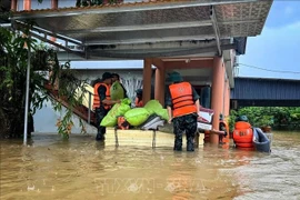
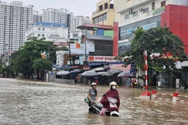
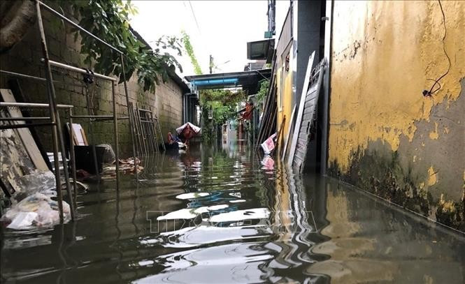
In recent days, continuous downpours have severely affected several central provinces. In Hue, major streets were submerged. Local authorities have warned of prolonged flooding in downstream areas, flash floods, and landslides in mountainous communes.

In Quang Ngai, heavy rain on October 25–26 triggered multiple landslides, isolating several communities. Over 70 households were relocated from high-risk zones, while transport routes such as National Highway 24C remain impassable.

In Kon Tum province’s Dak Plo commune, torrential rain caused serious landslides, damaging homes, roads, and crops. Nearly 450 households were temporarily cut off, and local authorities mobilised heavy machinery to restore access once conditions allow.

Local disaster response teams continue to monitor water levels, reinforce dykes and reservoirs, and coordinate evacuations to ensure public safety. Authorities have strictly prohibited travel through flooded or landslide-prone areas as central Vietnam braces for further heavy rain in the coming days./.

VNA

See more

Houses in Xuan Canh commune, Dak Lak province, completely collapse. (Photo: VNA)

Typhoon Kalmaegi damages over 26,470 houses and causes extensive losses

The typhoon and its aftermath left five people dead, three missing, and 17 injured. It also damaged 3,721 ha of rice and crops, and 3,958 ha of industrial and perennial fruit trees, up by 14 ha from the previous report. For aquaculture, 54,335 cages and 18 ha of shrimp and fish farms were destroyed, along with 118 cattle and 3,593 poultry. Additionally, 21 boats were sunk and 44 others damaged.

Nguyen Thi Vang is the oldest member of the scrap-collecting cooperative group in An Dong ward in Hue city. (Photo: VNA)

Hue turns waste into resource through tech-enabled scrap collectors

Through the mGreen application, women who once earned their living by collecting recyclable waste have become “green warriors” connected to a digital recycling supply chain. The initiative is not only improving livelihoods and enhancing social status but also forming a sustainable waste circulation loop, reinforcing Hue’s image as a green city.

Vice Chairman of the Hanoi People’s Committee Nguyen Manh Quyen receives Sylvain Ouillon, Chief Representative of the French National Research Institute for Sustainable Development (IRD) in Vietnam (Photo: Hanoi Moi)

Hanoi strengthens ties with IRD to tackle air pollution

Vice Chairman of the Hanoi People’s Committee Nguyen Manh Quyen on November 6 received Sylvain Ouillon, Chief Representative of the French National Research Institute for Sustainable Development (IRD) in Vietnam, to discuss potential cooperation in air quality monitoring and pollution reduction in the capital city.

Houses inundated by storm-triggered flooding. (Photo: VNA)

Central, Central Highlands localities race to recover from Storm Kalmaegi

According to Vietnam Disaster and Dyke Management Authority (VDDMA), the storm left five people dead and six injured. As of 7 a.m. on November 7, 52 houses had collapsed and 2,593 others were damaged or unroofed, including 2,412 in Gia Lai province. Nine fishing vessels were reported sunk.

High waves in Ly Son island, Quang Ngai province due to Typhoon Kalmaegi. (Photo: VNA)

Central, Central Highlands localities respond to Typhoon Kalmaegi

As Typhoon Kalmaegi, the 13th storm to hit the East Sea this year, intensifies and heads toward Vietnam’s central coast, localities across the central and Central Highlands regions, including Dak Lak, Lam Dong, Da Nang and Quang Ngai, have activated their highest-level disaster response measures to ensure the safety of people and property.

A map released at 2pm on November 4, tracking the path of Typhoon Kalmaegi (Source: National Centre for Hydro-Meteorological Forecasting)

PM urges proactive measures in response to Typhoon Kalmaegi

As Typhoon Kalmaegi is expected to enter the East Sea on the morning of November 5, with sustained winds of level 13–14 and gusts reaching level 17, Prime Minister Pham Minh Chinh has ordered ministries, sectors, and local authorities to implement the highest-level response measures to protect lives and minimise damage.

Residents in the buffer zone of the UNESCO-recognised Western Nghe An Biosphere Reserve (Photo: VNA)

Vietnam's World Biosphere Reserves eye to become ideal destinations

Vietnam's World Biosphere Reserves have truly become a rendezvous for integration, cooperation, and the exchange of information and experiences among countries and international organisations in the field of conservation and sustainable development, as well as an ideal destination for domestic and international tourists, heard a conference in the central province of Khanh Hoa on November 3.

Heavy rain and prolonged flooding have caused deep inundation, making transportation difficult. (Photo: VNA)

Heavy downpours, floods leave 37 dead, five missing

In addition, floods have submerged and damaged 7,897 hectares of paddy and crops, and 64,356 livestock and poultry have died or been swept away. Across the nation, 103 houses have collapsed or been washed away, 451 others damaged, and 12,676 flooded.