Typhoon Bualoi lashes Vietnam’s central coast with gales and downpours

​At 4am on September 29, the storm centre was located at 18.5 degrees north latitude and 105.5 degrees east longitude directly over Ha Tinh province coastline, packing winds of level 10–11 (89–117 km/h) with gusts up to 13.

Flooding on Giang street in Huong Son, Ha Tinh province, at 6:20 am on September 29, 2025. (Photo: VNA)

Ha Tinh (VNS/VNA) - Typhoon Bualoi (Storm No.10) made landfall over central Vietnam early September 29, unleashing gale-force winds and torrential downpours across a wide area.

The National Centre for Hydro-Meteorological Forecasting reported maximum gusts on land reaching level 14 at Hoanh Son Station in the central province of Ha Tinh, the strongest recorded so far.

At coastal monitoring stations, winds of level 7 with gusts up to 9 were reported at Co To (the northern province of Quang Ninh), level 8 with gusts 9 at Bach Long Vi (Hai Phong city), and level 9 with gusts 13 at Hon Ngu (Nghe An province), where storm surge rose to 1.6m. At Con Co island (Quang Tri province), winds reached level 10 with gusts 11, while Ky Anh (Ha Tinh province) recorded level 10 with gusts 12.

At 4am on September 29, the storm centre was located at 18.5 degrees north latitude and 105.5 degrees east longitude directly over the Ha Tinh coastline, packing winds of level 10–11 (89–117 km/h) with gusts up to 13. Moving west-northwest at 20–25 km/h, it is forecast to weaken into a tropical depression and later into a low-pressure system over northern Laos by late afternoon.

The storm has generated violent seas with waves of 3–5m from Thanh Hoa to Quang Tri and 2–4m across the northern Gulf of Tonkin. Storm surge of 0.5–1.5m is threatening low-lying coastal areas from Hai Phong city to Nghe An province, especially during high tide.

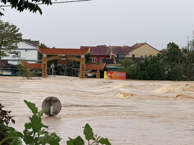
Heavy rainfall is expected on September 29 and 30. Downpours of 150–250 mm, with isolated totals exceeding 400 mm, are forecast for the northern delta, Phu Tho, Son La and Lao Cai, and provinces from Thanh Hoa to Ha Tinh. Elsewhere in the north and Quang Tri, totals of 100–200 mm, locally above 300 mm, are predicted. Authorities have warned of flash flooding, landslides and inundation in low-lying areas./.

VNA

See more

Air pollution in Hanoi. (Photo: VNA)

Hanoi to launch 5,000 public electric bicycles

In a move to reduce air pollution and promote green mobility, Hanoi has approved a plan to deploy 5,000 public electric bicycles, alongside restrictions on petrol- and diesel-powered vehicles in the city’s central area.

Official heritage plaque i sinstalled on the 12 recognised Shan Tuyet tea trees in Dong Phuc commune. (Photo: VNA)

Thai Nguyen: 12 ancient Shan Tuyet tea trees win national heritage status

The recognition honours the biological, cultural and historical values of these centuries-old Shan Tuyet tea trees – natural treasures deeply woven into the livelihoods, traditions and identity of local ethnic communities. The title affirms the community’s commitment to preserving and promoting the value of this iconic local tea variety.

Sarus cranes at Tram Chim National Park (Photo: VNA)

Return of sarus cranes: Hope takes wing in Dong Thap wetland

Beneath the wide Mekong Delta sky, Tram Chim National Park is racing against time, pouring heart and science into a decade-long (2022–2032) plan to rescue the Eastern sarus crane – an elegant, scarlet-headed bird listed as endangered on the International Union for the Conservation of Nature (IUCN) Red List and a living emblem of both the park and all of Dong Thap province

French Ambassador Olivier Brochet speaks at the press conference in Hanoi on December 11 to mark the 10th anniversary of the Paris Agreement on climate change and highlighting the COP30 outcomes. (Photo: VNA)

International community ready to support Vietnam in energy transition, climate response

In a video message to the press conference, UN Resident Coordinator in Vietnam Pauline Tamesis said the UN is ready to support Vietnam in building a pipeline of projects capable of absorbing financing mobilised under the Political Declaration on establishing the Just Energy Transition Partnership (JETP), as well as from global climate finance sources, including the Green Climate Fund and the Loss and Damage Fund.

Forest rangers in Son La province apply technological devices and software to forest management, monitoring, and protection. (Photo: nhandan.vn)

Digital technology application enhances forest management, protection

With a total forest area of over 14 million hectares, including more than 10 million hectares of natural forests, forests exist in all 34 provinces and cities across the country. Given the large area and limited workforce, applying digital solutions in forest management and protection has become a top priority for the forestry sector.

Sunda pangolins (Manis javanica), also known as the Javan pangolin, are listed in Group IB – critically endangered and strictly protected from all commercial exploitation (Photo: VNA)

Quang Ngai releases rare pangolin back into nature

Initial verification showed that the animal weighed 3.7kg and measured over 60cm. It was identified as a Sunda pangolin (Manis javanica), also known as the Javan pangolin, listed in Group IB – critically endangered and strictly protected from all commercial exploitation.

Residents of Tuyen Quang province take part in the One Billion Trees Programme. (Photo: VNA)

Tree-planting programme exceeds one-billion-tree goal

The total comprises 573.9 million scattered trees and 865.2 million trees grown in concentrated plantations, equivalent to 429,125 hectares of forest. Provinces posting the strongest results include Phu Tho with 177.9 million trees, Lao Cai with 108.8 million, and An Giang with 98.5 million.

Construction activity is one of the causes of air pollution in Hanoi. (Photo: VNA)

Hanoi takes urgent measures to curb air pollution

The city requires the enhanced application of advanced technologies and remote monitoring systems, including satellite remote sensing, drones, and AI-integrated traffic cameras, to monitor, detect, and strictly address the illegal burning of garbage, straw, and agricultural by-products.