Central localities to suffer torrential rains as Storm Fengshen approaching mainland

Heavy rain in the central region may persist until the end of October, with high risks of flash floods, landslides in mountainous areas, and flooding in low-lying and urban zones.

Storm Fengshen's moving direction as of 7 am on October 22 (Photo published by VNA)

Hanoi (VNA) – Storm Fengshen, the 12th in the East Sea this year, has maintained its intensity and path, and is forecast to trigger torrential rains of 200–400mm and even 500mm from Ha Tinh to Quang Ngai in central Vietnam, according to National Centre for Hydro-Meteorological Forecasting.

The centre warned that from midday October 22 to October 27, widespread downpour will affect the areas from Ha Tinh to Quang Ngai, with the most intense precipitation expected between the afternoon of October 22 and the end of October 23. From the southern part of Quang Tri to Da Nang, rainfall could reach 500–700mm, with some places over 900mm. Rainfall intensity may exceed 200mm within three hours.

From the afternoon of October 22, the storm’s circulation, combined with a strong cold front, will bring increasingly strong winds along coastal areas from Quang Tri to Da Nang.

Heavy rain in the central region may persist until the end of October, with high risks of flash floods, landslides in mountainous areas, and flooding in low-lying and urban zones.

Director of the centre Mai Van Khiem advised the affected localities to ensure safety for hydroelectric and irrigation reservoirs before, during, and after the storm, and prepare flood response plans for rivers from Quang Tri to Quang Ngai, where water levels could reach or exceed Level 3. The disaster risk due to flooding is forecast at Level 3.

Precautions are also necessary against thunderstorms and tornadoes with strong gusts during the storm’s approach and landfall, he said.

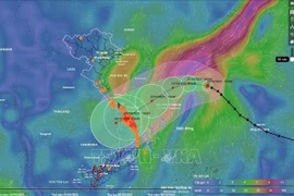
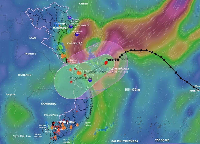
At 7 am on October 22, Fengshen’s eye was located at approximately 17.1°N and 110.7°E, over the northwestern waters of the Hoang Sa special zone, about 280km east-northeast of Da Nang. Maximum winds near the centre were about 89–102 km per hour. The storm was moving west-southwest at about 10 km per hour.

By 7 am on October 23, it is expected to reach the coast from Hue to Quang Ngai, continuing the west-southwest direction at 10–15 km per hour and gradually weakening into a tropical depression. The affected areas include the western part of the northern East Sea, including Hoang Sa and the waters from Quang Tri to Quang Ngai, including the special zones of Con Co and Ly Son, and Cu Lao Cham Island. The disaster risk remains at Level 3.

By 7 pm on October 23, the storm will move over southern Laos, abating further into a low-pressure area./.

VNA

See more

Official heritage plaque i sinstalled on the 12 recognised Shan Tuyet tea trees in Dong Phuc commune. (Photo: VNA)

Thai Nguyen: 12 ancient Shan Tuyet tea trees win national heritage status

The recognition honours the biological, cultural and historical values of these centuries-old Shan Tuyet tea trees – natural treasures deeply woven into the livelihoods, traditions and identity of local ethnic communities. The title affirms the community’s commitment to preserving and promoting the value of this iconic local tea variety.

Sarus cranes at Tram Chim National Park (Photo: VNA)

Return of sarus cranes: Hope takes wing in Dong Thap wetland

Beneath the wide Mekong Delta sky, Tram Chim National Park is racing against time, pouring heart and science into a decade-long (2022–2032) plan to rescue the Eastern sarus crane – an elegant, scarlet-headed bird listed as endangered on the International Union for the Conservation of Nature (IUCN) Red List and a living emblem of both the park and all of Dong Thap province

French Ambassador Olivier Brochet speaks at the press conference in Hanoi on December 11 to mark the 10th anniversary of the Paris Agreement on climate change and highlighting the COP30 outcomes. (Photo: VNA)

International community ready to support Vietnam in energy transition, climate response

In a video message to the press conference, UN Resident Coordinator in Vietnam Pauline Tamesis said the UN is ready to support Vietnam in building a pipeline of projects capable of absorbing financing mobilised under the Political Declaration on establishing the Just Energy Transition Partnership (JETP), as well as from global climate finance sources, including the Green Climate Fund and the Loss and Damage Fund.

Forest rangers in Son La province apply technological devices and software to forest management, monitoring, and protection. (Photo: nhandan.vn)

Digital technology application enhances forest management, protection

With a total forest area of over 14 million hectares, including more than 10 million hectares of natural forests, forests exist in all 34 provinces and cities across the country. Given the large area and limited workforce, applying digital solutions in forest management and protection has become a top priority for the forestry sector.

Sunda pangolins (Manis javanica), also known as the Javan pangolin, are listed in Group IB – critically endangered and strictly protected from all commercial exploitation (Photo: VNA)

Quang Ngai releases rare pangolin back into nature

Initial verification showed that the animal weighed 3.7kg and measured over 60cm. It was identified as a Sunda pangolin (Manis javanica), also known as the Javan pangolin, listed in Group IB – critically endangered and strictly protected from all commercial exploitation.

Residents of Tuyen Quang province take part in the One Billion Trees Programme. (Photo: VNA)

Tree-planting programme exceeds one-billion-tree goal

The total comprises 573.9 million scattered trees and 865.2 million trees grown in concentrated plantations, equivalent to 429,125 hectares of forest. Provinces posting the strongest results include Phu Tho with 177.9 million trees, Lao Cai with 108.8 million, and An Giang with 98.5 million.

Construction activity is one of the causes of air pollution in Hanoi. (Photo: VNA)

Hanoi takes urgent measures to curb air pollution

The city requires the enhanced application of advanced technologies and remote monitoring systems, including satellite remote sensing, drones, and AI-integrated traffic cameras, to monitor, detect, and strictly address the illegal burning of garbage, straw, and agricultural by-products.