Typhoon Matmo heading to Quang Ninh with powerful winds

Typhoon Matmo, the 11th storm to hit the East Sea, is forecast to be over the waters of Quang Ninh on the night of October 5, with very strong winds of level 12–13 and gusts reaching level 16, said Associate Professor Dr. Mai Van Khiem, Director of the National Centre for Hydro-meteorological Forecasting (NCHMF).

Photo: Screenshot
Photo: Screenshot

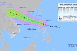
Hanoi (VNA) – Typhoon Matmo, the 11th storm to hit the East Sea, is forecast to be over the waters of Quang Ninh on the night of October 5, with very strong winds of level 12–13 and gusts reaching level 16, said Associate Professor Dr. Mai Van Khiem, Director of the National Centre for Hydro-meteorological Forecasting (NCHMF).

At 10 pm on October 5, the storm is expected to be located over the sea area off Quang Ninh with winds at level 11–12, gusting up to level 15, moving west-northwest at a speed of 20–25 km per hour. Affected areas include the north-western part of the northern East Sea, the northern Gulf of Tonkin, and coastal areas from Quang Ninh to Hung Yen and Lang Son provinces. The disaster risk level is assessed at level 3.

By 10 am on October 6, the typhoon is forecast to reach the border area between Lang Son (Vietnam) and Guangxi (China), with winds of level 6–7, gusting to level 9, continuing west-northwest at about 20 km per hour. The affected areas remain the northern Gulf of Tonkin and coastal provinces from Quang Ninh to Hung Yen, including Lang Son. The disaster risk level remains at level 3.

By 10 pm on October 6, the storm will have weakened into a tropical depression over the northern mountainous region, with winds below level 6, moving west-northwest at around 20 km per hour.

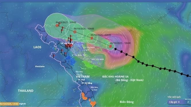
Due to the impact of the typhoon, the north-western waters of the northern East Sea will experience strong winds at levels 8–10, increasing to 11–13 near the storm’s centre, with gusts up to level 15–16. Wave heights are forecast at 4–6m, reaching 6–8m near the eye of the storm, causing extremely rough seas with destructive potential capable of sinking large vessels.

Coastal and island areas of Quang Ninh and Hai Phong provinces will see storm surges of 0.4–0.6 m. Low-lying coastal and estuarine areas are advised to take precautions against flooding and high waves from the afternoon and evening of October 5.

Weather conditions at sea and in coastal areas during the storm will be extremely hazardous, unsafe for all vessels and structures within the affected zones. Strong winds, large waves and storm surges could overturn or destroy boats and cause coastal flooding.

From the night of October 5 to the night of October 7, heavy to very heavy rainfall is forecast across the northern midland and mountainous regions, with common rainfall of 150–250mm and isolated areas exceeding 400mm.

The northern delta and Thanh Hoa provinces are expected to see moderate to heavy rain, ranging from 70–150mm, with localised downpours above 200mm. Rainfall intensity may exceed 150mm within three hours in some areas.

Total rainfall between October 5 and 7 is projected at 150–250mm in the northern mountainous and midland regions, with some areas surpassing 400mm, while the northern delta and Thanh Hoa may record 70–150mm, locally above 200mm.

Heavy rains could cause flooding in low-lying and urban areas, flash floods in small rivers and streams, and landslides on steep slopes.

The NCHMF also warned of potential flooding on rivers in the northern region and Thanh Hoa, with disaster risk at level 2.

According to the Civil Aviation Authority of Vietnam (CAAV), airports forecast to be directly affected include Van Don International Airport in Quang Ninh province and Cat Bi Airport in Hai Phong City. Meanwhile, Noi Bai International Airport in Hanoi, as well as Tho Xuan, Vinh and Dien Bien airports in Thanh Hoa, Nghe An and Dien Bien provinces, respectively, have been advised to stay updated and prepared for any abnormal developments of the storm./.

VNA

See more

Official heritage plaque i sinstalled on the 12 recognised Shan Tuyet tea trees in Dong Phuc commune. (Photo: VNA)

Thai Nguyen: 12 ancient Shan Tuyet tea trees win national heritage status

The recognition honours the biological, cultural and historical values of these centuries-old Shan Tuyet tea trees – natural treasures deeply woven into the livelihoods, traditions and identity of local ethnic communities. The title affirms the community’s commitment to preserving and promoting the value of this iconic local tea variety.

Sarus cranes at Tram Chim National Park (Photo: VNA)

Return of sarus cranes: Hope takes wing in Dong Thap wetland

Beneath the wide Mekong Delta sky, Tram Chim National Park is racing against time, pouring heart and science into a decade-long (2022–2032) plan to rescue the Eastern sarus crane – an elegant, scarlet-headed bird listed as endangered on the International Union for the Conservation of Nature (IUCN) Red List and a living emblem of both the park and all of Dong Thap province

French Ambassador Olivier Brochet speaks at the press conference in Hanoi on December 11 to mark the 10th anniversary of the Paris Agreement on climate change and highlighting the COP30 outcomes. (Photo: VNA)

International community ready to support Vietnam in energy transition, climate response

In a video message to the press conference, UN Resident Coordinator in Vietnam Pauline Tamesis said the UN is ready to support Vietnam in building a pipeline of projects capable of absorbing financing mobilised under the Political Declaration on establishing the Just Energy Transition Partnership (JETP), as well as from global climate finance sources, including the Green Climate Fund and the Loss and Damage Fund.

Forest rangers in Son La province apply technological devices and software to forest management, monitoring, and protection. (Photo: nhandan.vn)

Digital technology application enhances forest management, protection

With a total forest area of over 14 million hectares, including more than 10 million hectares of natural forests, forests exist in all 34 provinces and cities across the country. Given the large area and limited workforce, applying digital solutions in forest management and protection has become a top priority for the forestry sector.

Sunda pangolins (Manis javanica), also known as the Javan pangolin, are listed in Group IB – critically endangered and strictly protected from all commercial exploitation (Photo: VNA)

Quang Ngai releases rare pangolin back into nature

Initial verification showed that the animal weighed 3.7kg and measured over 60cm. It was identified as a Sunda pangolin (Manis javanica), also known as the Javan pangolin, listed in Group IB – critically endangered and strictly protected from all commercial exploitation.

Residents of Tuyen Quang province take part in the One Billion Trees Programme. (Photo: VNA)

Tree-planting programme exceeds one-billion-tree goal

The total comprises 573.9 million scattered trees and 865.2 million trees grown in concentrated plantations, equivalent to 429,125 hectares of forest. Provinces posting the strongest results include Phu Tho with 177.9 million trees, Lao Cai with 108.8 million, and An Giang with 98.5 million.

Construction activity is one of the causes of air pollution in Hanoi. (Photo: VNA)

Hanoi takes urgent measures to curb air pollution

The city requires the enhanced application of advanced technologies and remote monitoring systems, including satellite remote sensing, drones, and AI-integrated traffic cameras, to monitor, detect, and strictly address the illegal burning of garbage, straw, and agricultural by-products.