Hanoi (VNS/VNA) - Typhoon Kalmaegi has intensified as it is moving rapidly towards the central East Sea, bringing the risk of strong winds, heavy rain, and high waves to Vietnam’s central region in the coming days, the National Centre for Hydro-Meteorological Forecasting (NCHMF) reported.
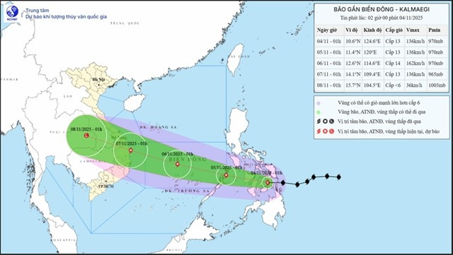
At 1:00 on November 4, the storm’s centre was located near 10.6 degrees North latitude and 124.6 degrees East longitude, over central Philippines, with maximum sustained winds of 134–149km per hour - level 13 - and gusts up to level 16. It is moving west at around 25km per hour.
By early November 5, Kalmaegi is expected to cross the Philippines and enter the East Sea, maintaining winds of level 12–13 and gusts up to level 16. The disaster risk level is 3.
By November 6, the typhoon could reach the central East Sea, about 630km east-southeast of Gia Lai province, with winds of level 14, gusting to level 17, moving west-northwest at 25km per hour. It is forecast to affect the Spratly Islands area, with risk level 3, and approach coastal waters from Quang Ngai to Dak Lak by November 7, where the risk level could rise to 4. The storm is expected to gradually weaken after 72–96 hours.
From the afternoon of November 4, strong winds of level 6–7, later increasing to 8–9, will impact the eastern central East Sea, with areas near the storm center seeing winds of level 11–13 and waves 5–7m high.
Between November 5–6, offshore areas from Da Nang to Khanh Hoa, including the Spratly Islands, could face winds of level 12–14, gusts above 17, and waves up to 10 metres, making seas extremely rough.
Heavy rain is forecast for Ha Tinh to Quang Tri on November 4, with rainfall of 50–110mm, and some areas exceeding 200mm. Rain will gradually decrease from November 5. Other regions, including Thanh Hoa, Nghe An, Hue and Quang Ngai, and parts of the Central Highlands, will also see scattered showers and thunderstorms.
The NCHMF also warned of rising river levels and possible flooding in Ha Tinh and Quang Tri, along with risks of flash floods and landslides in mountainous areas. The flood-related disaster risk level is 2./.
See more
Hanoi strengthens ties with IRD to tackle air pollution
Vice Chairman of the Hanoi People’s Committee Nguyen Manh Quyen on November 6 received Sylvain Ouillon, Chief Representative of the French National Research Institute for Sustainable Development (IRD) in Vietnam, to discuss potential cooperation in air quality monitoring and pollution reduction in the capital city.
Central, Central Highlands localities race to recover from Storm Kalmaegi
According to Vietnam Disaster and Dyke Management Authority (VDDMA), the storm left five people dead and six injured. As of 7 a.m. on November 7, 52 houses had collapsed and 2,593 others were damaged or unroofed, including 2,412 in Gia Lai province. Nine fishing vessels were reported sunk.
Typhoon Kalmaegi causes 11 casualties, widespread damage in central region
Typhoon Kalmaegi, the 13th storm arising in the East Sea so far this year, along with its circulation had left five people dead and six injured as of early November 7, and caused widespread damage in central localities.
Typhoon Kalmaegi weakens into tropical depression, forecast to cause heavy rains
The tropical depression, which had weakened from Typhoon Kalmaegi – the 13th storm hitting the East Sea this year, has downgraded into a low-pressure area over southern Laos, on November 7 early morning, according to the National Centre for Hydro-Meteorological Forecasting (NCHMF).
Typhoon Kalmaegi weakens over Gia Lai–Dak Lak, continues to bring torrential rain
Typhoon Kalmaegi has been causing widespread heavy rain from southern Quang Tri to Dak Lak, with rainfall ranging from 100 to 250mm, and in some areas exceeding 300mm.
From awareness to action: Shifting consumer habits towards sustainability
Sustainable consumption is not simply a social trend but a vital requirement for Vietnam’s deeper international integration and sustainable development.
Central, Central Highlands localities respond to Typhoon Kalmaegi
As Typhoon Kalmaegi, the 13th storm to hit the East Sea this year, intensifies and heads toward Vietnam’s central coast, localities across the central and Central Highlands regions, including Dak Lak, Lam Dong, Da Nang and Quang Ngai, have activated their highest-level disaster response measures to ensure the safety of people and property.
Typhoon Kalmaegi moves faster, now about 310 km from Quy Nhon
By 7 a.m. on November 7, the storm is expected to continue moving west-northwest, make landfall, and weaken into a tropical depression over southern Laos.
Typhoon Kalmaegi to bring torrential rain to central region over next two days
Kalmaegi is a strong and fast-moving storm with a broad circulation, with a track and pattern of impact similar to Typhoon Damrey (2017) and Typhoon Molave (2020).
Typhoon Kalmaegi to hit central Vietnam on early November 7
By 1:00 am on November 7, the typhoon is predicted to make landfall along the coast from Quang Ngai to Dak Lak, sustaining winds at Level 12 with gusts up to Level 15.
PM urges proactive measures in response to Typhoon Kalmaegi
As Typhoon Kalmaegi is expected to enter the East Sea on the morning of November 5, with sustained winds of level 13–14 and gusts reaching level 17, Prime Minister Pham Minh Chinh has ordered ministries, sectors, and local authorities to implement the highest-level response measures to protect lives and minimise damage.
Vietnam's World Biosphere Reserves eye to become ideal destinations
Vietnam's World Biosphere Reserves have truly become a rendezvous for integration, cooperation, and the exchange of information and experiences among countries and international organisations in the field of conservation and sustainable development, as well as an ideal destination for domestic and international tourists, heard a conference in the central province of Khanh Hoa on November 3.
Heavy downpours, floods leave 37 dead, five missing
In addition, floods have submerged and damaged 7,897 hectares of paddy and crops, and 64,356 livestock and poultry have died or been swept away. Across the nation, 103 houses have collapsed or been washed away, 451 others damaged, and 12,676 flooded.
Severe flooding inundates Hue city as rivers overflow alarm level 3
Early on November 3, a landslide occurred on National Highway 49 at Kim Quy Pass between Binh Dien and A Luoi communes, disrupting traffic on the key route linking Hue city with its western mountainous districts.
Agricultural sector to cut at least 15% greenhouse gas emissions by 2035
The project on low-emission crop production for the period for 2025-2035, with a vision extending to 2050, focuses on high-emission crops such as rice, cassava, sugarcane, coffee, and bananas. It aims to pilot at least 15 farming models nationwide that are ready for carbon credits and meet international standards.
PM orders urgent support for flood-hit localities
To ensure residents' safety and prevent hunger and disease outbreaks, the PM asked the Minister of Finance to immediately allocate rice from national reserves to flood-hit communities, based on requests from provincial authorities, including Quang Ngai. Implementation results should be reported to the PM by October 31.
JICA provides over 9 billion VND to help Can Tho improve drainage system
Japan's Fukuoka city will share its experience and advanced technologies to help Can Tho tackle three major issues: flood damage and untreated wastewater discharge, inefficient management of wastewater treatment plants, and low public awareness about connecting private drains to public systems.
Central Vietnam hit by torrential rains till late October
The deluge stems from a combination of atmospheric factors, including a low-altitude cold air mass, a northward movement of the intertropical convergence zone and humid easterly winds at elevations between 1,500m and 5,000m, NCHMF Director Assoc. Prof Mai Van Khiem said, adding that this configuration is a classic driver of prolonged, high-intensity rainfall in the region.
National Defence Ministry directs urgent response to severe flooding in central region
Under the document, the ministry requested military forces to maintain high alert, monitor flood developments, and swiftly deploy resources to ensure the safety of military bases, warehouses, and operational areas.
Record-breaking floods loom on Vu Gia–Thu Bon rivers
The meteorological agency has issued a warning of prolonged and widespread flooding in low-lying and riverside areas, with severe inundation expected in urban zones in Da Nang. There is also a high risk of flash floods and landslides in the mountainous areas of Da Nang city.