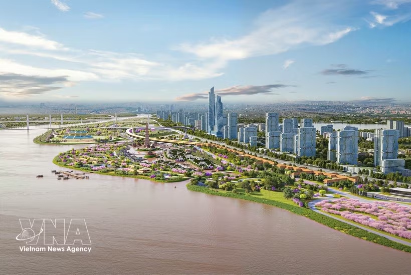
Hanoi (VNA) – The Hanoi People’s Committee on May 19 issued an official press release providing key details on the Red River Scenic Boulevard Axis project, which is identified as a strategic and long-term development orientation for the capital city in its new development phase.
The project is implemented in line with guidelines, resolutions, and conclusions from the Party Central Committee, the National Assembly, the Government, and the city authorities. Notably, the NA’s Resolution No. 258/NQ-QH15 dated December 11, 2025 allows the application of special mechanisms and policies for implementation. On May 11, 2026, the municipal People’s Council issued Resolution No. 18/NQ-HDND, giving in-principle approval to the project.
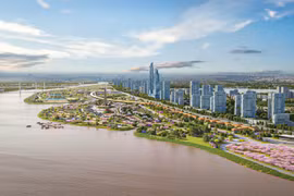
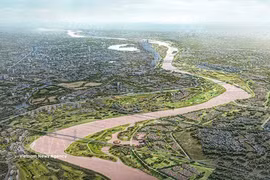
Under the capital’s master plan with a 100-year vision, the Red River Scenic Boulevard Axis is designated as one of nine key development corridors of Hanoi. It is envisioned as a central green spatial corridor, while also functioning as an economic, commercial, service, cultural, creative, and urban development axis along the Red River.
Covering a total land area of approximately 11,418 ha, the project consists of five main project groups with 18 sub-projects. These include two scenic boulevards running along the sides of the Red River with a combined length of over 80 km; large-scale park complexes in riverside alluvial areas; river embankment and channel regulation works; resettlement and urban redevelopment zones; and independent land clearance projects.
It will be implemented across 16 wards and communes, including Hong Ha, O Dien, Thuong Cat, Dong Ngac, Phu Thuong, Linh Nam, Thanh Tri, Nam Phu, Hong Van, Me Linh, Thien Loc, Vinh Thanh, Dong Anh, Bo De, Long Bien, and Bat Trang. The project is scheduled for implementation from 2026 to 2038. In the first phase from 2026 to 2030, priority will be given to key infrastructure works, river embankment and channel regulation projects, major parks, resettlement urban areas, and site clearance activities.
The municipal People’s Committee said the preliminary total investment is estimated at around 736.96 trillion VND (27.95 billion USD). The proposed land fund for payment covers around 2,655.8 hectares, to be allocated in urban development areas within the project scope and partly from other land reserves across the city. The municipal authorities affirmed that the management and use of this land fund, as well as project implementation, will ensure transparency, efficiency, and the prevention of losses and waste of public assets.
Regarding resettlement, the municipal People’s Committee noted that the current population within the project area is about 70,474 households with 247,431 people. The city’s consistent principle is to ensure the legitimate rights and interests of affected residents, while prioritising the implementation of resettlement and reconstruction projects before the synchronised rollout of other project components, it asserted.
Resettlement areas are planned in Long Bien, Linh Nam, and Bat Trang, with total number of resettlement units, including both land-based housing and high-rise apartments, projected to reach 79,000-85,000, broadly meeting the resettlement demands of affected residents.
The Red River Scenic Boulevard Axis is said to hold a strategic importance for Hanoi’s urban space, landscape, ecological environment, and development capacity, contributing to forming a new central landscape axis and gradually realising the vision of urban development along the banks of the Red River in a civilised, modern, ecological, and sustainable manner./.